Baduria
Baduria is a city and a municipality in Basirhat subdivision[2] of North 24 Parganas district in the state of West Bengal, India.
Baduria | |
|---|---|
City | |
 Sarkhel Para, Baduria | |
 Baduria Location in West Bengal, India  Baduria Baduria (India) | |
| Coordinates: 22.74°N 88.79°E | |
| Country | |
| State | West Bengal |
| District | North 24 Parganas |
| Government | |
| • Type | Municipality |
| • Body | Baduria Municipality |
| • Municipality Chairman | Tusher Singha |
| Area | |
| • Total | 22.43 km2 (8.66 sq mi) |
| Elevation | 8 m (26 ft) |
| Population (2001) | |
| • Total | 47,418 |
| • Density | 2,100/km2 (5,500/sq mi) |
| Languages | |
| • Official | Bengali, English |
| Time zone | UTC+5:30 (IST) |
| ISO 3166 code | IN-WB |
| Lok Sabha constituency | Basirhat |
| Vidhan Sabha constituency | Baduria |
| Website | http://baduriamunicipality.in |
Geography
Baduria is located at 22.74°N 88.79°E.[3] It has an average elevation of 8 metres (26 feet).
The headquarters of Baduria CD Block at Iswarigachha are located just outside the municipal limits of Buduria town.[4]
Police station
Baduria police station covers an area of 218 km2 and serves a population of 305,000. It has jurisdiction over Baduria municipal area and Baduria CD Block. It has two outposts: Baduria town outpost and Puro outpost. There is a totally unfenced international border stretching across 2.5 km.[5]
Demographics
As per the 2011 Census of India, Baduria had a total population of 52,493, of which 26,799 (51%) were males and 25,694 (49%) were females. Population below 6 years was 5,185. The total number of literates in Baduria was 38,770 (81.95% of the population over 6 years).[6]
As of 2001 India census,[7] Baduria had a population of 47,418. Males constitute 51% of the population and females 49%. Baduria has an average literacy rate of 67%, higher than the national average of 59.5%; with 55% of the males and 45% of females literate. 13% of the population is under 6 years of age.
Transport
State Highway 3 (locally known as Habra-Baisrhat Road) passes through Baduria.[8][9]
Education
Baduria Dilip Kumar Memorial Institution (co-educational), Baduria L.M.S. High School (co-educational) and Baduria L.M.S. Girls High School (girls only) are higher secondary schools located in Baduria.[10]
Healthcare
Rudrapur (Baduria) Rural Hospital with 60 beds functions as the main medical facility in Baduria CD Block. There are primary health centres at Dakshin Chatra (with 6 beds), Jadurhati (with 6 beds), and Model Belghoria (Bajitpur PHC with 10 beds).[11]
Baduria picture gallery
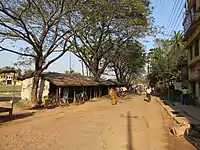 The Berachampa-Baduria Road at Baduria sub-post office
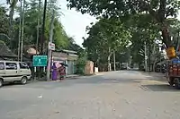 Matia-Baduria Road Dhalipara
 The Ichhamati at Purba Para
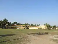 Dilip Kumar Memorial Institution
 Raksha Kali shrine
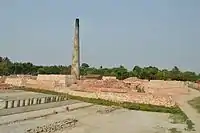 Brickfield
References
- "Baduria City".
- District-wise list of statutory towns Archived 27 September 2007 at the Wayback Machine
- Falling Rain Genomics, Inc – Baduria
- "District Census Handbook North Twenty Four Parganas, Census of India 2011, Series 20, Part XII A" (PDF). Page 481: Map of Baduria CD Block, also showing Baduria municipal area. Directorate of Census Operations, West Bengal. Retrieved 29 May 2018.
- "North 24 Parganas Dist. Police". Know Your Police Station. District Police. Retrieved 29 May 2018.
- "2011 Census – Primary Census Abstract Data Tables". West Bengal – District-wise. Registrar General and Census Commissioner, India. Retrieved 29 May 2018.
- "Census of India 2001: Data from the 2001 Census, including cities, villages and towns (Provisional)". Census Commission of India. Archived from the original on 16 June 2004. Retrieved 1 November 2008.
- "List of State Highways in West Bengal". West Bengal Traffic Police. Retrieved 29 May 2018.
- Google maps
- "Exam Venue". West Bengal Council of Higher Secondary Education. Retrieved 30 May 2018.
- "Health & Family Welfare Department". Health Statistics. Government of West Bengal. Retrieved 29 May 2018.
North 24 Parganas district topics | |||||||||
|---|---|---|---|---|---|---|---|---|---|
| General |
| ||||||||
| Subdivisions | |||||||||
| Municipalities | |||||||||
| Community development blocks |
| ||||||||
| Rivers | |||||||||
| Transport |
| ||||||||
| Railway stations | |||||||||
| Institutes of higher learning |
| ||||||||
| Lok Sabha constituencies | |||||||||
| Vidhan Sabha constituencies |
| ||||||||
| Former Vidhan Sabha constituencies | |||||||||
| See also |
| ||||||||
