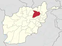
Baghlani Jadid District
Baghlani Jadid (surface: 1,613 km2) is a district of Baghlan Province in northern Afghanistan. It has a population of about 119,607.
Baghlani Jadid
بغلان جدید | |
|---|---|
District | |
 Baghlani Jadid Location within Afghanistan | |
| Coordinates: 36°19′48″N 68°37′12″E | |
| Country | |
| Province | Baghlan Province |
| Area | |
| • Total | 1,613 km2 (623 sq mi) |
| Population (2004) | |
| • Total | 119,607 |
Geography
The district is situated in the northernmost part of the province. It borders Kunduz Province to the north and Samangan Province to the west . Most of the population live in the valley of the Kunduz River. The majority of its territory is uninhabited mountain ranges. An all-weather Kunduz-Kabul highway passes through the district from north to south. The main city is Baghlani Jadid. In 2005, Baghlani Jadid absorbed the district of Baghlan-e-Markazi, also in Baghlan Province, to create a new and bigger Baghlani Jadid district.
Demographics
According to Afghanistan's Ministry of Rural Rehabilitation and Development, the population of the district was estimated to be around 119,607 in 2004.[1] Ethnically, Pashtuns are around 50% of the population and make up the majority in the district,[2] followed by Tajiks at 40% and Uzbeks make up the remaining 10%.[3]
References
- Ministry of Rural Rehabilitation and Development (MRRD) Baghlan Provincial profile
- Baghlan province profile, Naval Postgraduate School (NPS)
- Baghlani Jadid profile, UNHCR and Afghanistan Information Management Services (AIMS)