Kaldar District
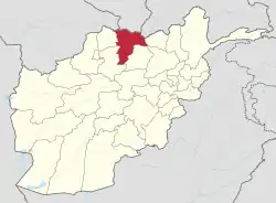
Kaldar (Dari: کلدار) is a small district (population around 19,400)[2] in the northern part of Balkh Province, Afghanistan. The northern and the eastern border of the district is the large Amu Darya river. North of the river is Uzbekistan and east is Tajikistan. The main village, also called Kaldar, is in the northeastern part of the district, close to the river.
Kaldar
کلدار | |
|---|---|
 Kaldar Location within Afghanistan[1] | |
| Coordinates: 37°07′48″N 67°33′00″E | |
| Country | |
| Province | Balkh Province |
| Population (2012) | |
| • Total | 19,400 |
Demographics
According to the 2012-13 census, there are 19,400 people living in the village. 9,900 or 51.0% of borough residents were males and 9,500 or 49.0% were females. With a multi-ethnic and mostly Persian-speaking society.[3]
The major ethnic group is the Tajiks with the vast population belonging to them followed by Pashtoons Uzbek, Hazaras, Turkman, Arab and Baluch. Kaldar also has a small but noticeable population of Kuchis or nomads whose numbers vary in different seasons with numbers going down in the winter and up in the summer.
References
- "District Names". National Democratic Institute. Archived from the original on 29 January 2016. Retrieved 27 July 2015.
- "Settled Population of Balkh Province" (PDF). Central Statistics Organisation. Retrieved 27 July 2015.
- "Balkh Province". Program for Culture & Conflict Studies. Naval Postgraduate School. Archived from the original on May 29, 2012. Retrieved 2013-06-16.
Districts Landforms Landmarks and culture