Nawur District
Nawur is the largest district in Afghanistan's Ghazni Province by area. Its population, which is entirely Hazara, was estimated at 91,778 (more than half of whom were children under 12) in 2002.[1] The Jikhai River originates here. Nawur with 5234 square kilometre is located in northern part of Ghazni Province, Nawur is neighbour with Qarabagh District in south, Jaghuri District, Malistan District and Ajristan District (Daya) in south west, Jaghatu District and Rashidan District in east, Miramor District of Daikundi province in west, Waras District of Bamian Province in north west, Behsud District, Daimirdad District and Jeghatu District of Maidan Wardak Province in north.
Nawur
ناور | |
|---|---|
District | |
 Nawur Location within Afghanistan | |
| Coordinates: 33°47′30″N 67°51′30″E | |
| Country | |
| Province | Ghazni Province |
| Area | |
| • Total | 5,234 km2 (2,021 sq mi) |
| Population (2002)[1] | |
| • Total | 91,778 |
Agriculture
Main crops include wheat and barley. Animal husbandry includes sheep, goats, cows, poultry and horses.[1]
In 2011, Polish members of the Provincial Reconstruction Team (PRT) along with local residents constructed a dam and new passage in Tal Bulagh valley. Supplies of water gathered will allow to irrigate crop fields.[2]
External links
- Map of Settlements AIMS, May 2002
See also
References
- "District Profile" (PDF). UNHCR. Archived from the original (PDF) on 27 October 2005. Retrieved 21 April 2006.
- "Drought no longer dreadful for residents of Nawur District". Polish Aid. Retrieved 4 November 2015.
| Districts | 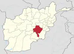 | |
|---|---|---|
| Populated places |
| |
| Landforms | ||
| Other | ||