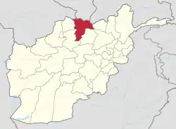
Charkint District
Charkint, or Chahar Kint, (Dari: چارکنت) is a district in Balkh Province, Afghanistan. It has a population of 32,306.[1] The district administration is located in Shar Shar area of Charkint district, which means "four clusters/towns" - from Persian chahār, "four", and Sogdian[2] kand, "town" (Turkicized to kint). The area of the district is 1,357 square kilometres (524 sq mi).
Charkint
چارکنت | |
|---|---|
 Charkint Location within Afghanistan | |
| Coordinates: 36°30′00″N 67°20′00″E | |
| Country | |
| Province | Balkh Province |
| Area | |
| • Total | 1,357 km2 (524 sq mi) |
| Population | |
| • Total | 32,306 |
See also
References
- http://www.mrrd.gov.af/nabdp/Provincial%20Profiles/Balkh%20PDP%20Provincial%20profile.pdf Archived 2010-07-07 at the Wayback Machine Ministry of Rural Rehabilitation and Development of Afghanistan
- Room, Adrian (2006). Placenames of the World: Origins and Meanings of the Names for 6,600 Countries, Cities, Territories, Natural Features and Historic Sites (2nd ed.). London: McFarland. p. 330. ISBN 0-7864-2248-3.
Samarkand. The city derives its name from [...] Sogdian kand, "fort", "town".
This article is issued from Wikipedia. The text is licensed under Creative Commons - Attribution - Sharealike. Additional terms may apply for the media files.