Ab Band District
Ab Band is a district in Ghazni Province, Afghanistan.[1] Its population, which is almost entirely Pashtun, was estimated at 41,340 in 2002. The district is within the heartland of the Tarakai tribe of Ghilji Pashtuns.[2] Ab Band is on the main road from Kabul to Kandahar. The district capital is Āb Band.
Ab Band
آب بند | |
|---|---|
District | |
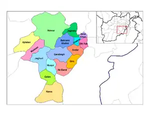 Ab Band District in light red | |
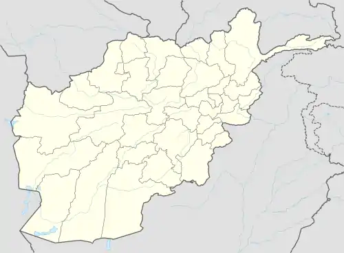 Ab Band Location within Afghanistan | |
| Coordinates: 32°58′59″N 67°58′01″E | |
| Country | |
| Province | Ghazni Province |
| Population (2002) | |
| • Total | 41,340 |
Politics and Governance
Much of Ab Band villages are now under Taliban control; only the district headquarters is under government control.
Geography
Ab Band is divided into two parts, North and South Aband. Between the two is a desert and a river which flows to the south into a lake. Ab band has a number of very nice and wild mountains and hills such as Khwaja Lal Mountain, Zarcha, Laka tega, Khar koshta mountains, Zegay hills and wat Ghar plus many small mores.
Demographics
There are four famous ethnic groups settled in Ab Band: Buden Khail, Na Khail, Mul Khail and Sorkhail.
Economy
Ab Band has no construction projects; its local people regularly go to Pakistan and Iran for work. There is also a small bazaar (town) for locals to purchase daily needs and meet neighbor villagers. The bazaar is between Bazi and Chawnai villages. Ab Band people are really poor; they struggle and work at agriculture fields for over 6 months to afford only the harsh winter.
Infrastructure
There is no main road specially, in the south during the winter about 2 or half months access to the area blocks by snow, people only go by foot.
Natural Resources
Ab Band is popular for its tasty grapes and resins that are usually exported to Ghazni city and Muqur district for trade and exchange for goods. The water sources are Kariz's (a trench 4–5 km long underground at the starting point it might be 35 m deep, but the end water reaches to the surface and flows like mesh). During the 2000s drought most of them become dried and people rushed for water pump drills. However, there is another problem villagers are disagree with water pumps because they will dry the rest of the Kariz's in the region.
References
- "District Profile" (PDF). UNHCR. Archived from the original (PDF) on 27 October 2005. Retrieved 15 October 2015.
- Ghazni Province Tribal Map (Page 4). Naval Postgraduate School.
- UNHCR District Profile, accessed 2006-04-20
External links
- Map of Settlements AIMS, May 2002
| Districts | 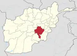 | |
|---|---|---|
| Populated places |
| |
| Landforms | ||
| Other | ||