Rural Municipality of Longlaketon No. 219
The Rural Municipality of Longlaketon No. 219 (2016 population: 1,016) is a rural municipality (RM) in the Canadian province of Saskatchewan within Census Division No. 6 and SARM Division No. 2.
Longlaketon No. 219 | |
|---|---|
| Rural Municipality of Longlaketon No. 219 | |
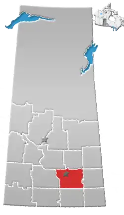
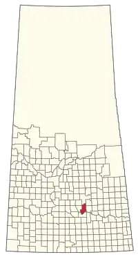 Location of the RM of Longlaketon No. 219 in Saskatchewan | |
| Coordinates: 50.785°N 104.702°W[1] | |
| Country | Canada |
| Province | Saskatchewan |
| Census division | 6 |
| SARM division | 2 |
| Formed[2] | December 12, 1910 |
| Government | |
| • Reeve | Delbert Schmidt |
| • Governing body | RM of Longlaketon No. 219 Council |
| • Administrator | Courtney Huber |
| • Office location | Earl Grey |
| Area (2016)[4] | |
| • Land | 1,024.59 km2 (395.60 sq mi) |
| Population (2016)[4] | |
| • Total | 1,016 |
| • Density | 1/km2 (3/sq mi) |
| Time zone | CST |
| • Summer (DST) | CST |
| Area code(s) | 306 and 639 |
History
The RM of Longlaketon No. 219 incorporated as a rural municipality on December 12, 1910.[2]
- Heritage properties
There are three historical sites located within the RM.
- Eddy School No. 1846 - Constructed in 1922, the site contains a one-room school house that served as a school from 1922–1936, 1943–1957. The school is located near Earl Grey.[5]
- Longlaketon United Church (also called the Longlaketon Presbyterian Church) - Constructed in 1886, the building is now used as the Longlaketon Community Hall. Church services were held from 1886 to 1969.[6]
- Zion (North Southey) Lutheran Church - Constructed in 1926, by immigrants from the imperial Austrian Empire, the church provides services in German until the 1960s.[7]
Demographics
In the 2016 Census of Population conducted by Statistics Canada, the RM of Longlaketon No. 219 recorded a population of 1,016 living in 384 of its 420 total private dwellings, a 5.6% change from its 2011 population of 962. With a land area of 1,024.59 km2 (395.60 sq mi), it had a population density of 1.0/km2 (2.6/sq mi) in 2016.[4]
In the 2011 Census of Population, the RM of Longlaketon No. 219 recorded a population of 962, a 7% change from its 2006 population of 899. With a land area of 1,024.57 km2 (395.59 sq mi), it had a population density of 0.9/km2 (2.4/sq mi) in 2011.[10]
Government
The RM of Longlaketon No. 219 is governed by an elected municipal council and an appointed administrator that meets on the second Tuesday of every month.[3] The reeve of the RM is Delbert Schmidt while its administrator is Courtney Huber.[3] The RM's office is located in Earl Grey.[3]
References
- "Pre-packaged CSV files - CGN, Canada/Province/Territory (cgn_sk_csv_eng.zip)". Government of Canada. July 24, 2019. Retrieved May 23, 2020.
- "Rural Municipality Incorporations (Alphabetical)". Saskatchewan Ministry of Municipal Affairs. Archived from the original on April 21, 2011. Retrieved May 9, 2020.
- "Municipality Details: RM of Longlaketon No. 219". Government of Saskatchewan. Retrieved May 21, 2020.
- "Population and dwelling counts, for Canada, provinces and territories, and census subdivisions (municipalities), 2016 and 2011 censuses – 100% data (Saskatchewan)". Statistics Canada. February 8, 2017. Retrieved May 1, 2020.
- Eddy School
- Longlaketon United Church
- Zion (North Southey) Lutheran Church
- "Saskatchewan Census Population" (PDF). Saskatchewan Bureau of Statistics. Archived from the original (PDF) on September 24, 2015. Retrieved May 9, 2020.
- "Saskatchewan Census Population". Saskatchewan Bureau of Statistics. Retrieved May 9, 2020.
- "Population and dwelling counts, for Canada, provinces and territories, and census subdivisions (municipalities), 2011 and 2006 censuses (Saskatchewan)". Statistics Canada. June 3, 2019. Retrieved May 1, 2020.