Greenhorn Limestone
The Greenhorn Limestone or Greenhorn Formation is a geologic formation in the Great Plains Region of the United States, dating to the Cenomanian and Turonian ages of the Late Cretaceous period.
| Greenhorn Limestone Stratigraphic range: Cenomanian-Turonian, around 94.3–89.3 Ma | |
|---|---|
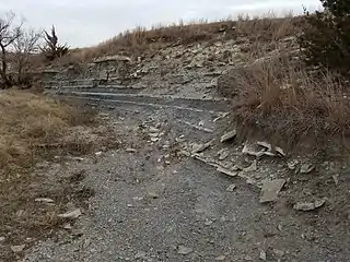 The Jetmore Chalk Member of the Greenhorn Formation in Kansas. | |
| Type | Formation |
| Unit of | Colorado Group (lower), Benton Formation/Group, or Cody Shale |
| Sub-units | Colorado members: Bridge Creek Limestone Hartland Shale Lincoln Limestone Kansas members: Pfeifer Shale (with Fencepost ls) Jetmore Chalk Hartland Shale Lincoln Limestone |
| Underlies | Carlile Shale |
| Overlies | Graneros Shale |
| Lithology | |
| Primary | Shale to chalky shale Limestone, chalk to marl |
| Other | bentonite |
| Location | |
| Coordinates | 38.277°N 104.713°W |
| Region | mid-continental |
| Country | United States |
| Type section | |
| Named for | Greenhorn Station, 14 mi south of Pueblo, CO, and for Greenhorn Creek[1] |
| Named by | Grove Karl Gilbert |
| Year defined | 1896[2] |
Description
The formation was named for the Greenhorn Station on Greenhorn Creek in Colorado in 1896 by Grove Karl Gilbert;[2] and it is the namesake of the Greenhorn Marine Cycle of the Cretaceous Western Interior Seaway. With the underlying Graneros Shale and Dakota Formation, it records the progressive stage of Greenhorn Marine Cycle while the overlying Carlile Shale records the regressive stage.
The Greenhorn unit name is recognized in the Great Plains Region from Minnesota and Iowa to New Mexico to Montana and the Dakotas. In much of Alberta and Saskatchewan, the "Second White-Specked Shale" contains limy equivalents of the Greenhorn.[3]
In Kansas, the Greenhorn Formation is divided into the (lowest) Lincoln Limestone, Hartland Shale, Jetmore Chalk, and (highest) Pfeifer shale members, each noted by changes in chalkiness and limestone rhythmite patterns.[4] In Colorado and western Kansas Hydrocarbon exploration, the divisions are Lincoln Limestone, Hartford Shale, and Bridge Creek Limestone.[5] In other states, where the formation is less developed, the unit is not subdivided and is named the Greenhorn Limestone, as a formation or as a member of another formation, e.g., Cody Shale.
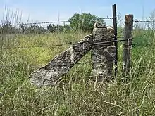
Within Kansas and a small neighboring portion of Nebraska, the Greenhorn Formation is particularly noted for its uppermost bed, the Fencepost limestone, from which the Kansas stone posts were quarried. The combination of the toughness of the Fencepost limestone with the softness of the chalk and shale above and below as resulted in the formation of the main range of the Smoky Hills north and west of Salina. In 2018, Kansas Legislation HB 2650[6] designated the Greenhorn Limestone formation, specifically "the famous “post rock” limestone" bed of that unit,[7] to be the state rock of Kansas.
Lithologic character
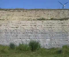
The Greenhorn Formation is characterized as shale to chalky shale, light bluish-gray in color, with rhythmically repeating beds of chalk or limestone that become marly closer to the Rocky Mountains. The shale can weather to buff color under hilltops.
Exposures show many thin, rust-colored bentonite beds (named for the Old Benton Limestone classification that the Greenhorn and other names replaced), several of which are consistent and widespread marker beds. These orange seams in the weathered shale and the yellow/orange stainings of some of the weathered limestones in the Greenhorn are associated with volcanic events in the Sevier orogeny.[8] The oceanic iron (Fe) and volcanic sulfur (S) that precipitated with the volcanic ash into the calcareous mud (CaCO3) formed pyrite (FeS2), which later altered to selenite (CaSO4·2H2O), siderite (FeCO3), and limonite (FeO(OH)·nH2O),[9] leading to the yellow to orange staining.
Paleofauna
The formation is recognized for its sequence of index fossils, including Ostrea, Ammonoidea, Belemnitida, and Inoceramidae.[10]
Dinosaur remains have been recovered from the formation.[11]
See also
- Volcanic mineralization of the Greenhorn sequence:
- Bentonite, sedimentary volcanic ash, general showing some weathered iron stain in the Colorado Group
- Pyrite, precipitation of volcanic sulfuric acid with oceanic iron as FeS2
- Limonite, pyrite in limestone weathered to HFeO2 (rust stain or yellow ochre)
- Selenite, CaSO4 associated with Bentonite seams and ochre [12]
- List of dinosaur-bearing rock formations
- List of fossiliferous stratigraphic units in Colorado
- List of fossiliferous stratigraphic units in Kansas
- List of fossiliferous stratigraphic units in Minnesota
- Paleontology in Colorado
- Paleontology in Kansas
- Paleontology in Minnesota
References
- "Geologic Unit: Greenhorn". National Geologic Database. Geolex — Unit Summary. United States Geological Survey. Retrieved 2018-03-11.
- Donald E. Hattin (1975). Stratigraphy and Depositional Environment of Greenhorn Limestone (Upper Cretaceous) of Kansas, Kansas Geological Survey, Bulletin 209. University of Kansas Publications, State Geological Survey of Kansas. p. History of Stratigraphic Nomenclature.
- W.J. Frazier, D.R. Schwimmer (11 November 2013). Regional Stratigraphy of North America. p. 420. ISBN 9781461317951.CS1 maint: uses authors parameter (link)
- Donald E. Hattin (1975). Stratigraphy and Depositional Environment of Greenhorn Limestone (Upper Cretaceous) of Kansas, Kansas Geological Survey, Bulletin 209. University of Kansas Publications, State Geological Survey of Kansas. p. Stratigraphy of the Greenhorn Limestone.
- Cobban, W.A., and Scott, G.R. (1972), Stratigraphy and ammonite fauna of the Graneros Shale and Greenhorn Limestone near Pueblo, Colorado, Professional Paper 645, U.S. Geological SurveyCS1 maint: uses authors parameter (link)
- Kansas HB 2650, 2019
- Jackson & Mariner Svaty (2018-03-15), Testimony in Support of H.B. 2650 (PDF),
Mr. Chairman, we would recommend that rather than naming the state rock “limestone”, which is prevalent in different forms around the country, we should declare a limestone specific to Kansas as the state rock. Our recommendation would be Greenhorn limestone, the famous “post rock” limestone that has the largest distribution statewide,[sic - Cottonwood and other limestones have larger distributions in the state] running from Ford County all the way to Washington County [i.e., Smoky Hills], and can be seen as fenceposts everywhere in between.
- Donald E. Hattin (1975). Stratigraphy and Depositional Environment of Greenhorn Limestone (Upper Cretaceous) of Kansas, Kansas Geological Survey, Bulletin 209. University of Kansas Publications, State Geological Survey of Kansas. p. Stratigraphy of the Greenhorn Limestone, continued.
These [many bentonite] seams represent devitrified volcanic ash from sources in the Sevier orogenic belt (Fig. 21)
- Donald E. Hattin (1965). Stratigraphy of the Graneros Shale (Upper Cretaceous) in Central Kansas, Kansas Geological Survey, Bulletin 178. University of Kansas Publications, State Geological Survey of Kansas. p. Origin of Sediments: Diagenesis (In the Graneros the source of the sulfide is organic decay, but in the Colorado group the source is volcanic emissions.).
- Donald E. Hattin (1975). Stratigraphy and Depositional Environment of Greenhorn Limestone (Upper Cretaceous) of Kansas, Kansas Geological Survey, Bulletin 209. University of Kansas Publications, State Geological Survey of Kansas. p. Biostratigraphy.
- Weishampel, David B; et al. (2004). "Dinosaur distribution (Late Cretaceous, North America)." In: Weishampel, David B.; Dodson, Peter; and Osmólska, Halszka (eds.): The Dinosauria, 2nd, Berkeley: University of California Press. Pp. 574-588. ISBN 0-520-24209-2.
- Alvin R. Leonard and Delmar W. Berry (1961). Geology and Ground-water Resources of Southern Ellis County and Parts of Trego and Rush Counties, Kansas, Bulletin 149. University of Kansas Publications, State Geological Survey of Kansas. p. Geologic Formations in Relation to Ground Water.
The upper 175 feet of the Carlile is classed as the Blue Hill Shale member. Most of it is blue-gray fissile argillaceous shale that contains selenite crystals and flakes of bright yellow ochre.
CS1 maint: uses authors parameter (link)
