County of Brant
The County of Brant (2016 population 36,707) is a single-tier municipality in the Canadian province of Ontario. Despite its name, it is no longer a county by definition, as all municipal services are handled by a single level of government. The county has service offices in Burford, Paris, Oakland, Onondaga and St. George.
Brant | |
|---|---|
| County of Brant | |
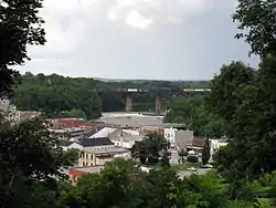 Paris, Ontario | |
| Motto(s): Simply Grand | |
 | |
| Coordinates: 43°07′N 80°22′W | |
| Country | Canada |
| Province | Ontario |
| Settled | 1793 |
| Formed | 1851 (county) |
| Formed | 1999 (single-tier city) |
| Seat | Burford |
| Government | |
| • Governing body | Brant County Council |
| • Mayor | David Bailey |
| • MP | Phil McColeman (Conservative) |
| • MPP | Will Bouma (Progressive Conservative) |
| Area | |
| • Land | 843.25 km2 (325.58 sq mi) |
| Population (2016)[1] | |
| • Total | 36,707 |
| • Density | 43.5/km2 (113/sq mi) |
| Time zone | UTC-5 (EST) |
| • Summer (DST) | UTC-4 (EDT) |
| Postal Code | N0E, N3L |
| Area code(s) | 519 and 226 |
| Website | www.brant.ca |
It is a predominantly rural municipality in Southern Ontario. The largest population centre (2016 population, 12,310) is Paris. The County is bordered by North Dumfries township, the City of Hamilton, Haldimand County, Norfolk County, and the townships of Blandford-Blenheim and Norwich. The County abuts the provincially-mandated Greenbelt (Golden Horseshoe).
Although the city of Brantford appears geographically to be located in the County, it is a fully independent city with its own municipal government.[2][3][4] The Brant census division, which includes Brantford and the Six Nations and New Credit reserves, along with the County of Brant, had a population of 134,808 in the 2016 census.
History
The area had previously been part of Wentworth and Oxford County. Brant County was formed in 1851 and originally consisted of:[5]
- Brantford Township (Brantford, Paris, Mount Pleasant, Cainsville), Area 71,122 acres (287.82 km2). First settlement made before 1810. The township was organized in 1840.
- Burford Township (Burford, Scotland), Area 71,122 acres (287.82 km2). First of the midland townships to have settlers. Surveyed in 1793, four families settled on the land before 1800.
- Oakland Township (Scotland, Oakland), Area 10,676 acres (43.20 km2). Originally called the Townsend Gore, then the Burford Gore, but organized a separate municipality in 1850.
- Onondaga Township (Onondaga, Middleport), Area 20,613 acres (83.42 km2). First settled in 1838. The formal surrender of the township by the Indians did not take place until 1839.
- South Dumfries Township (Paris, St. George, Glen Morris), Area 46,265 acres (187.23 km2).
- Tuscarora Township (Six Nations Indian Reserve, New Credit Indian Reserve), created in 1784.
On January 1, 1999, the Town of Paris and the townships of Brantford, Burford, Oakland, Onondaga, and South Dumfries amalgamated to form a new city with the official legal name of County of Brant.[6]
Early history
Erected by the provincial and federal governments, historic plaques and monuments in Brant County indicate a long and varied history which include many aspects related to the First Nations.
The famed Mohawk Chief Joseph Brant (Thayendanega) and the Mohawk people of New York state served with the British during the American Revolution. In 1784, the Crown granted Joseph Brant and his followers a land treaty along the Grand River to replace what they had lost in New York State at the Sandusky Council after the Revolution. Much of this grant was later rescinded.[7] As chief of the united tribes, Brant led his people to Upper Canada; a group of 400 settled in 1788 on the Grand River at Mohawk Village which later became Brantford.[8] Nearly a century later (1886), the Joseph Brant Memorial would be erected in Burlington, Ontario in honour of Brant and the Six Nations Confederacy.[9]
The Mohawk Chapel, built by the British Crown in 1785 for the Mohawk and Iroquois people (Six Nations of the Grand River), was dedicated in 1788 as a reminder of the original agreements made with the British during the American Revolution.[8] In 1904 the chapel received Royal status by King Edward VII in memory of the longstanding alliance. Her Majesty's Royal Chapel of the Mohawks is an important reminder of the original agreements made with Queen Anne in 1710. It is still in use today as one of two royal Chapels in Canada and the oldest Protestant Church in the province. Joseph Brant and his son John Brant are buried here.[10]
Significant to the County, gypsum was discovered in 1793 on the east bank of the Grand River in what became Paris during a survey for the British Home Department. By late 1794 a road had been built from what is now Dundas, Ontario to Paris, called The Governor's Road (now Dundas St. in Paris). Records from 1846 indicate that the settlement (now Paris), in a hilly area called Oak Plains, was divided into the upper town and the lower town. In addition to successful farmers in the area, the community of 1000 people (Americans, Scottish, English, and Irish) was thriving. Manufacturing had already begun, with industries powered by the river. A great deal of plaster was being exported and there were three mills, a tannery, a woolen factory, a foundry, and numerous tradesmen. Five churches had been built; the post office was receiving mail three times a week.[11] The village was incorporated in 1850 with Hiram "Boss" Capron as the first Reeve. It was incorporated as a town in 1856 with H. Finlayson as the first mayor.[8]
Abraham Dayton from Connecticut arrived in 1793 and was granted the entire township of Burford; additional settlers began arriving in 1797. The 1814 Battle of Malcolm's Mills during the War of 1812 took place at what is now Oakland when American forces attacked the local regiments. Neither this battle nor the 1837 Duncombe's Uprising by militant "Patriots" at the settlement of Scotland were successful.[8]
Chief John Brant (Mohawk leader) (Ahyonwaeghs) who had lived at Mohawk Village was one of the sons of Joseph Brant.[12] He fought with the British during the War of 1812 and later worked to improve the welfare of the First Nations. He was involved in building schools and was the improving the welfare of his people. Brant initiated the opening of schools and from 1828 served as the first native Superintendent of the Six Nations.[8] Chief Brant was elected to Legislative Assembly of Upper Canada for Haldimand in 1830 and was the first aboriginal Canadian in Parliament.[13]
Records from 1846 indicate that the settlement of Scotland in Burford Township had a population of about 150. At that time there were two stores, two taverns, one tannery, one saddler, one chair maker, one cabinet maker, one blacksmith. There was also a carding machine and fulling mill near the village. Nearby Oakland had about 160 inhabitants; its post office was receiving mail daily. Oakland had a grist and a saw mill, a carding machine and fulling mill, one store, two taverns, one hatter, one wagon maker, one blacksmith, one tailor, one shoemaker.[14]
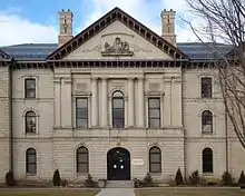
Much of the County's early population began arriving in the 1820s as the Hamilton and London Road was improved and settlement increased after 1848 when navigation to Brantford was opened and again in 1854 with the arrival of the railway to Brantford. The stone and brick Brant County Courthouse was built on land purchased from the Six Nations in 1852. The structure housed court rooms, county offices, a law library and a gaol. During additions in the 1880s, the Greek Revival style, with Doric columns, was retained.[8]
Chiefswood, now a Six Nations museum in Oshweken and one of the National Historic Sites of Canada, was built in about 1856 by Mohawk Chief George Henry Martin Johnson (Onwanonsyshon). His daughter, the Mohawk poet E. Pauline Johnson (Tekahionwake), gained great acclaim across Canada. Her work increased awareness of the history and cultural diversity of the First Nations. In 1886, the Joseph Brant Memorial was constructed in honour of Brant and the Six Nations Confederacy.[8][15]
Invention of the telephone
Alexander Graham Bell invented the telephone at his father's homestead, Melville House, now the Bell Homestead National Historic Site. At the time, the homestead was in the County, outside the Brantford city limits.[16][17][18] In a 1906 speech, Bell made the following comment, "the telephone problem was solved, and it was solved at my father's home".[19] As well, two of the first successful voice transmissions of any notable distance were made in early August 1876, between the telegraph office in Brantford, Ontario and Melville House and Between Paris and Brantford.[20][21][22][23]
Canada's first telephone factory, created and operated by James Cowherd, was also located in Brantford from about 1879 until his death in 1881.[24][25] The first telephone business office which opened in 1877, not far from the Bell Homestead, was then located in the County just outside Brantford.[8]
Geography
Communities
In addition to Brantford, population centres in Brant are Paris, St. George and Burford. Smaller communities in the municipality include Bishopsgate, Burtch, Cainsville, Cathcart, East Oakland, Etonia, Fairfield, Falkland, Glen Morris, Gobles, Harley, Harrisburg, Hatchley, Langford, Lockie, Maple Grove, Middleport, Mount Pleasant, Mount Vernon, New Durham, Newport, Northfield, Northfield Centre, Oakland, Onondaga, Osborne Corners, and Scotland.
Climate
| Climate data for Middleport (1981−2010) | |||||||||||||
|---|---|---|---|---|---|---|---|---|---|---|---|---|---|
| Month | Jan | Feb | Mar | Apr | May | Jun | Jul | Aug | Sep | Oct | Nov | Dec | Year |
| Record high °C (°F) | 15.5 (59.9) |
16.0 (60.8) |
25.0 (77.0) |
31.0 (87.8) |
33.0 (91.4) |
36.5 (97.7) |
38.0 (100.4) |
35.0 (95.0) |
33.5 (92.3) |
27.0 (80.6) |
22.0 (71.6) |
20.5 (68.9) |
38.0 (100.4) |
| Average high °C (°F) | −1.4 (29.5) |
0.0 (32.0) |
4.6 (40.3) |
12.1 (53.8) |
19.3 (66.7) |
24.7 (76.5) |
27.4 (81.3) |
25.8 (78.4) |
21.3 (70.3) |
14.7 (58.5) |
7.3 (45.1) |
1.7 (35.1) |
13.1 (55.6) |
| Daily mean °C (°F) | −5.4 (22.3) |
−2.5 (27.5) |
0.1 (32.2) |
6.9 (44.4) |
13.4 (56.1) |
18.7 (65.7) |
21.5 (70.7) |
20.1 (68.2) |
15.8 (60.4) |
9.7 (49.5) |
3.5 (38.3) |
−1.9 (28.6) |
8.2 (46.8) |
| Average low °C (°F) | −9.4 (15.1) |
−8.5 (16.7) |
−4.4 (24.1) |
1.7 (35.1) |
7.4 (45.3) |
12.7 (54.9) |
15.5 (59.9) |
14.4 (57.9) |
10.2 (50.4) |
4.6 (40.3) |
−0.4 (31.3) |
−5.4 (22.3) |
3.2 (37.8) |
| Record low °C (°F) | −31.0 (−23.8) |
−31.0 (−23.8) |
−23.0 (−9.4) |
−15.0 (5.0) |
−5.0 (23.0) |
2.0 (35.6) |
7.0 (44.6) |
1.0 (33.8) |
−2.0 (28.4) |
−7.0 (19.4) |
−15.0 (5.0) |
−27.5 (−17.5) |
−31.0 (−23.8) |
| Average precipitation mm (inches) | 66.6 (2.62) |
55.4 (2.18) |
64.0 (2.52) |
74.6 (2.94) |
76.5 (3.01) |
76.9 (3.03) |
98.7 (3.89) |
75.2 (2.96) |
92.3 (3.63) |
73.4 (2.89) |
84.6 (3.33) |
70.8 (2.79) |
908.9 (35.78) |
| Average rainfall mm (inches) | 32.3 (1.27) |
30.9 (1.22) |
47.8 (1.88) |
71.7 (2.82) |
76.4 (3.01) |
76.9 (3.03) |
98.7 (3.89) |
75.2 (2.96) |
92.3 (3.63) |
73.2 (2.88) |
77.8 (3.06) |
49.1 (1.93) |
802.3 (31.59) |
| Average snowfall cm (inches) | 34.4 (13.5) |
24.4 (9.6) |
16.2 (6.4) |
2.9 (1.1) |
0.1 (0.0) |
0.0 (0.0) |
0.0 (0.0) |
0.0 (0.0) |
0.0 (0.0) |
0.2 (0.1) |
6.8 (2.7) |
21.7 (8.5) |
106.7 (42.0) |
| Average precipitation days (≥ 0.2 mm) | 13.9 | 10.7 | 11.5 | 13.8 | 12.9 | 11.0 | 10.7 | 11.0 | 13.1 | 14.1 | 14.3 | 13.8 | 150.7 |
| Average rainy days (≥ 0.2 mm) | 5.3 | 5.1 | 8.0 | 13.1 | 12.9 | 11.0 | 10.7 | 11.0 | 13.1 | 14.1 | 12.8 | 8.5 | 125.4 |
| Average snowy days (≥ 0.2 cm) | 9.3 | 6.4 | 4.7 | 0.89 | 0.05 | 0.0 | 0.0 | 0.0 | 0.0 | 0.05 | 2.0 | 6.6 | 29.9 |
| Source: Environment Canada[26] | |||||||||||||
Demographics
| Canada census – County of Brant community profile | |||
|---|---|---|---|
| 2016 | 2011 | ||
| Population: | 36,707 (3.0% from 2011) | 35,638 (3.6% from 2006) | |
| Land area: | 843.25 km2 (325.58 sq mi) | 843.29 km2 (325.60 sq mi) | |
| Population density: | 43.5/km2 (113/sq mi) | 42.3/km2 (110/sq mi) | |
| Median age: | |||
| Total private dwellings: | 13,687 | ||
| Median household income: | |||
| References: 2016[27] 2011[28] earlier[29] | |||
Population trend:[30]
- Population in 2006: 34,415
- Population in 2001: 31,669
- Population in 1996: 29,800
- Brantford (township): 6487
- Burford (township): 5858
- Oakland (township): 1377
- Onondaga (township): 1650
- Paris (town): 8987
- South Dumfries (township): 5441
- Population in 1991: 26,864
- Brantford (township): 6509
- Burford (township): 5733
- Oakland (township): 1398
- Onondaga (township): 1519
- Paris (town): 8600
- South Dumfries (township): 4624
| Visible minority and Aboriginal population (Canada 2016 Census) | |||
|---|---|---|---|
| Population group | Population | % of total population | |
| Visible minority group Source:Census 2016 |
South Asian | 195 | 0.5% |
| Chinese | 100 | 0.3% | |
| Black | 220 | 0.6% | |
| Filipino | 70 | 0.2% | |
| Latin American | 60 | 0.2% | |
| Arab | 15 | 0% | |
| Southeast Asian | 15 | 0% | |
| Korean | 60 | 0.2% | |
| Japanese | 20 | 0.1% | |
| Visible minority, n.i.e. | 30 | 0.1% | |
| Multiple visible minority | 10 | 0% | |
| Total visible minority population | 800 | 2.2% | |
| Aboriginal | First Nations | 675 | 1.8% |
| Métis | 235 | 0.6% | |
| Aboriginal, n.i.e. | 15 | 0% | |
| Multiple Aboriginal identity | 10 | 0% | |
| Total Aboriginal population | 935 | 2.5% | |
| European | 34,972 | 95.3% | |
| Total population | 36,707 | 100% | |
Government
The County of Brant is divided into five wards, each with two elected Councillors. David Bailey was elected as the Mayor in 2018. Previously, Ronald Eddy had held the position of Mayor from 1999 - 2018.[31] The County is a single-tier municipality and provide the following services: roads, water, wastewater, garbage, recycling, facilities, parks, trails, planning, building, economic development, tourism, bylaw enforcement, library, fire and paramedic services but contracts with the Ontario Provincial Police to provide police services, overseen by the Police Services Board. (Ambulance services are provided in conjunction with the City of Brantford.) The customer service offices are located in Burford, Paris, Oakland, Onondaga and St. George Ontario.[32][33]
Local organizations
Local organizations include the Kinsmen Club of Brantford is an all Canadian non-profit service organization that promotes service, fellowship, positive values, and national pride. They put on the Brantford Kinsmen Annual Car Show & Swap Meet in Paris Ontario in September and the Brantford Kinsmen Annual Ribfest in Brantford, Ontario to help raise funds for local charities. And Sustainable Brant dedicated to saving the disappearing farmland.
The County of Brant Public Library is the public library serving the communities in the county of Brant, Ontario, Canada. It has 5 branches located in Paris, Burford, Scotland, St. George, and Glen Morris, Ontario. The system's main branch, in Paris, Ontario, was originally a Carnegie Library, having received an endowment from Carnegie in 1902. The County of Brant Public Library maintains a Digital Historical Collection pertaining to Brant history at http://images.ourontario.ca/brant
Album of honour
The Album of Honour for Brant County is a book compiled in 1946 by the Kinsmen Club of Brantford to commemorate those of Brantford, the County of Brant and the peoples of the Six Nations who served Canada during the Second World War.[34] The book lists the names of the Brant County men and women who served in World War II. There are more than 3,500 photographs. In addition, local companies provided the names of employees who served in this war. The book is kept on the Digital Archives Page at the Brantford Public Library.[35]
See also
References
- "Brant census profile". 2016 Census of Population. Statistics Canada. Retrieved 2017-02-08.
- "Proposed Boundary Adjustment". Brant.ca. Archived from the original on 2017-04-07. Retrieved 2017-04-06.
- "Members of Council". Brantford.ca.
- "Councillors and Wards - County of Brant". Brant.ca. Archived from the original on 2018-04-02. Retrieved 2017-04-06.
- Province of Ontario -- A History 1615 to 1927 by Jesse Edgar Middletown & Fred Landon, 1927, Dominion Publishing Company, Toronto
- Interim List of Changes to Municipal Boundaries, Status and Name From January 2, 1996 to January 1, 2001. Statistics Canada. January 2002. p. 154 of 419.
- "Early Canada Historical Narratives -- THAYENDANEGEA - JOSEPH BRANT". Uppercanadahistory.ca.
- "Historical Plaques of Brant County". Waynecook.com.
- "Thayendanega (Joseph Brant) Historical Plaque". Ontarioplaques.com.
- "History". Mohawk Chapel. 2011. Archived from the original on 30 January 2017. Retrieved 7 April 2017.
- Smith, Wm. H. (1846). SMITH'S CANADIAN GAZETTEER - STATISTICAL AND GENERAL INFORMATION RESPECTING ALL PARTS OF THE UPPER PROVINCE, OR CANADA WEST. Toronto: H. & W. ROWSELL. p. 142.
- "War of 1812". Eighteentwelve.ca. Archived from the original on 2018-10-13. Retrieved 2019-07-10.
- "Ahyouwaighs, Chief of the Six Nations 1838". Vitacollections.ca.
- Smith, Wm. H. (1846). SMITH'S CANADIAN GAZETTEER - STATISTICAL AND GENERAL INFORMATION RESPECTING ALL PARTS OF THE UPPER PROVINCE, OR CANADA WEST. Toronto: H. & W. ROWSELL. p. 167 and 133.
- Canada, Library and Archives. "Emily Pauline Johnson (Tekahionwake) - Library and Archives Canada".
- "The Bell Homestead Historical Plaque". ontarioplaques.com.
- Whitaker, A.J. "Bell Telephone Memorial", City of Brantford/Hurley Printing, Brantford, Ontario, 1944. PDF.
- Osborne, Harold S. (1943) "Biographical Memoir of Alexander Graham Bell", National Academy of Sciences: Biographical Memoirs, Vol. XXIII, 1847–1922. PDF. Presented to the Academy at its 1943 annual meeting.
- Reville, F. Douglas (1920). History of the County of Brant (PDF). Brantford, Ontario: Hurley. p. 315. Archived from the original (PDF) on 31 March 2016. Retrieved 6 April 2017.
- "The Unveiling of the Bell Memorial" (PDF). Brantford.library.on.ca. Archived from the original (PDF) on 23 February 2017. Retrieved 21 October 2017.
- Reville, F. Douglas. History of the County of Brant Vol. 1. Brantford, ON: Brant Historical Society, Hurley Printing, 1920/. PDF pp. 187–197, or document pp. 308–322. (PDF)
- "Alexander Graham Bell & Brantford". Brantford.ca. Archived from the original on 2017-04-07. Retrieved 2017-04-06.
- MacLeod, Elizabeth (1999). Alexander Graham Bell: An Inventive Life. Toronto, Ontario: Kids Can Press. p. 14 to 19. ISBN 1-55074-456-9
- "Evolution of Telecommunications". Virtualmuseum.ca. Retrieved 21 October 2017.
- Murray, Robert P. (21 October 2017). The Early Development of Radio in Canada, 1901-1930: An Illustrated History of Canada's Radio Pioneers, Broadcast Receiver Manufacturers, and Their Products. Sonoran Publishing. ISBN 9781886606203. Retrieved 21 October 2017 – via Google Books.
- "Middleport TS, Ontario". Canadian Climate Normals 1981–2010. Environment Canada. Archived from the original on July 25, 2019. Retrieved July 25, 2019.
- "2016 Community Profiles". 2016 Canadian Census. Statistics Canada. February 21, 2017. Retrieved 2017-02-08.
- "2011 Community Profiles". 2011 Canadian Census. Statistics Canada. July 5, 2013.
- "2001 Community Profiles". 2001 Canadian Census. Statistics Canada. February 17, 2012.
- Statistics Canada: 1996, 2001, 2006 census
- "County of Brant". Brant.ca. Archived from the original on 2017-04-03. Retrieved 2017-04-07.
- "Emergency Services". Brant.ca. Archived from the original on 2017-05-04. Retrieved 2017-04-07.
- "County Government". Brant.ca.
- Album of Honor for Brant County (PDF). The Brantford Kinsmen Club. 1946.
- sicdesign.ca, Andrew MacLeod. "Genealogy Websites - Brantford Public Library". Brantford.library.on.ca. Archived from the original on 2007-07-02. Retrieved 2007-06-30.
External links
| Wikimedia Commons has media related to Brant County, Ontario. |
Places adjacent to County of Brant | |
|---|---|
| Regions | |
|---|---|
| Counties | |
| Districts | |
| Regional municipalities | |
| Single-tier municipalities | |
| Separated municipalities | |
| |