Peterborough County
Peterborough County is located in Southern Ontario, Canada. The county seat is Peterborough, which is independent of the county.
Peterborough County | |
|---|---|
| County of Peterborough | |
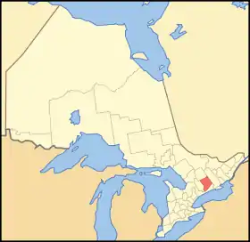 Location of Peterborough County | |
| Coordinates: 44°30′N 78°10′W | |
| Country | |
| Province | |
| Region | Central Ontario |
| Founded | 1838 (as District of Colborne) |
| County seat | Peterborough |
| Municipalities | |
| Area | |
| • Land | 3,769.29 km2 (1,455.33 sq mi) |
| Population (2016)[2] | |
| • Total | 55,800 |
| • Density | 14.8/km2 (38/sq mi) |
| Time zone | UTC-5 (EST) |
| • Summer (DST) | UTC-4 (EDT) |
| Website | www.ptbocounty.ca |
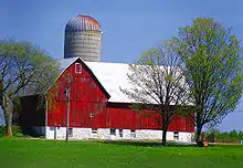
The southern section of the county is mix of agriculture, urban and lakefront properties. The northern section of the county is mostly sparsely populated wilderness with numerous rivers and lakes, mostly within the recently expanded Kawartha Highlands Provincial Park.
The County contains the Lang Pioneer Village, and the Kawarthas are a major tourist region.
History
| Map of Peterborough County, showing townships and main settlements.[3] |
Origins and evolution
In 1615, Samuel de Champlain was one of the first western explorers who traveled through the area, coming down from Lake Chemong and portaging down a trail, which is approximated by present-day Chemong Road, to the Otonabee River[4] and stayed for a brief time near the present-day site of Bridgenorth, just north of Peterborough.
The area was initially part of the Newcastle District, formed in 1802.[5] In 1841, the northern part of the District was detached to form the Colborne District, consisting of the County of Peterborough and other lands.[6] It consisted of the following territory:
| County of Peterborough |
|---|
|
The townships of
and
|
The county was named in honor of Col. Peter Robinson, who in 1825 brought 2,000 settlers from Ireland. The route taken was by way of Port Hope, Rice Lake and the Otonabee River, the same route used by the first settlers that entered this region in 1818.
The centre of the County was originally the courthouse, which is still considered an important historical site.
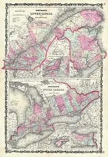
In 1851, Peterborough County was divided into the counties of Peterborough and Victoria, which were united for municipal purposes as the United Counties of Peterborough and Victoria.[8]
| County of Peterborough | County of Victoria |
|---|---|
|
|
A plebiscite was authorized in 1856 to facilitate the creation of a provisional county council for Victoria,[9] but, as the united counties council delayed conducting it, a further Act was passed in 1861 to compel its being held, following which the provisional council was formed.[10] and its formal separation took place in 1863.[11]
Further townships were surveyed, thus extending the reach of the County northwards. In 1874, the townships of Bruton, Cardiff, Dysart, Dudley, Glamorgan, Guilford, Harburn, Harcourt, Minden, Monmouth, Snowden and Stanhope were withdrawn from the County and transferred to the new Provisional County of Haliburton.[12]
After the transfer of the northern townships to Haliburton, the remainder of the County consisted of the following:[13]
| Townships | Area | Opened | Description |
|---|---|---|---|
| Asphodel | 37,871 acres (59.2 sq mi; 153.3 km2) | 1821 | Named after the Greek word for lily. |
| Belmont and Methuen | Area 81,088 acres (127 sq mi; 328 km2) | 1823 | By 1842 it had only 33 householders; in 1866 only 185. Townships were mainly rock, lake and stream. |
| Burleigh and Anstruther | 32,160 acres (50 sq mi; 130 km2) | 1861 | First Post Office was called Burleigh. Separated from Dummer Township in 1865. |
| Chandos | 56,225 acres (88 sq mi; 228 km2) | 1862 | Named after the Duke of Buckingham and Chandos |
| Douro | 34,446 acres (54 sq mi; 139 km2) | 1821 | Named after the Battle of Douro in the Peninsular War. |
| Dummer | 68,812 acres (108 sq mi; 278 km2) | 1821 | Named in honor of William Dummer Powell, Chief Justice of Upper Canada. A Colony of immigrants came in 1831, of whom 150 were sent out by the Marquess of Bath. |
| Ennismore | 17,245 acres (27 sq mi; 70 km2) | 1829 | Named in honor of William Hare, Viscount Ennismore, formerly M.P. for Cork City in the Parliament of Ireland, who died in 1827. Originally it was called Emily Gore. |
| Galway and Cavendish | 57,218 acres (89 sq mi; 232 km2) | 1857/1862 | |
| Harvey | 68,755 acres (107 sq mi; 278 km2) | 1821 | Named after Sir John Harvey, Deputy Adjutant General in Canada during the War of 1812. Was part of Smith township until 1866. First settler were retired officers who come in 1832, but did not succeed. |
| North Monaghan | 14,096 acres (22 sq mi; 57 km2) | 1820 | |
| Otonabee | 64,024 acres (100 sq mi; 259 km2) | 1820 | Named after the Otonabee River. The word in Indian signifies a delta. |
| Smith | 58,043 acres (90.7 sq mi; 234.9 km2) | 1819 | Settled by Allen Otty. |
The Town of Peterborough became a City in 1905, and was subsequently withdrawn from the County for municipal purposes.[14]
In 1974, as a result of the creation of the Regional Municipality of Durham, the township of Cavan and the village of Millbrook were withdrawn from Durham County, and the township of South Monaghan was withdrawn from Northumberland County, to be transferred to Peterborough County.[15]
Current municipalities
As a consequence of the Common Sense Revolution in Ontario, the County was restructured into the following municipalities during the period 1997-2004:
- Township of Asphodel-Norwood
- Township of Cavan-Monaghan
- Township of Douro-Dummer
- Township of Havelock-Belmont-Methuen
- Township of North Kawartha
- Township of Otonabee-South Monaghan
- Township of Selwyn
- Municipality (Township) of Trent Lakes
Two First Nations reserves are independent of county administration:
Demographics
The figures below are for the Peterborough census division, which combines Peterborough County, the City of Peterborough and the two First Nations reserves.
| Canada census – Peterborough County community profile | |||
|---|---|---|---|
| 2016 | 2011 | 2006 | |
| Population: | 138,236 (2.5% from 2011) | 134,933 (1.4% from 2006) | 133,080 (5.7% from 2001) |
| Land area: | 3,847.77 km2 (1,485.63 sq mi) | 3,805.71 km2 (1,469.39 sq mi) | |
| Population density: | 35.1/km2 (91/sq mi) | 35.0/km2 (91/sq mi) | |
| Median age: | 43.6 (M: 42.5, F: 44.6) | ||
| Total private dwellings: | 70,551 | 68,009 | 67,281 |
| Median household income: | |||
| References: 2016[2] 2011[16] 2006[17] earlier[18] | |||
The county is projected to reach a population of 159,840 by 2031, according to the Ontario Ministry of Finance's Ontario Population Projections Update[19]
Historic populations:[18]
- Population in 2001: 125,856
- Population in 1996: 123,448
The City of Peterborough makes up the majority of the population of the census division. Statistics for Peterborough County—without Peterborough and the First Nations reserves—are:
- Land area: 3,769.29 square kilometres (1,455.33 sq mi)
- Population (2011): 54,870
- Density: 14.6 per square kilometre (38/sq mi)
Major places
Media
In 1994, the Connection newspaper (previously known as Causeway Connection) established in Selwyn in central Peterborough County. The free monthly cottage country newspaper is distributed by mail, providing non-partisan news and information. The Connection is expanding both its distribution areas and internet presence.
References
- "Peterborough County census profile". 2011 Census of Population. Statistics Canada. Retrieved 2012-03-22.
- "2016 Community Profiles". 2016 Canadian Census. Statistics Canada. February 21, 2017.
- Restructured municipalities - Ontario map #5 (Map). Restructuring Maps of Ontario. Ontario Ministry of Municipal Affairs and Housing. 2006. Retrieved March 21, 2018.
- "Peterborough and the Kawarthas". Trent University. September 26, 2008. Archived from the original on February 11, 2009. Retrieved October 29, 2008.
- An Act to provide for the Administration of Justice in the District of Newcastle, S.U.C. 1802, c. 2
- An Act to authorize the Erection of certain Townships, and other territory heretofore forming part of the Newcastle District, into a new District, by the name of the District of Colborne, with Peterborough for the District Town, S.U.C. 1837, c. 115 , implemented by the Proclamation of October 14, 1841
- 1837 Act, s. 1
- An Act to make certain alterations in the Territorial Divisions of Upper Canada, S.C. 1851, c. 5, Sch. A-B
- An Act to provide for the separation of the County of Victoria from the County of Peterborough, and to fix the County Town at Lindsay, S.Prov.C. 1856, c. 95
- An Act to amend the Act to provide for the separation of the County of Victoria from the County of Peterborough, and to fix the County Town at Lindsay, S.Prov.C. 1861, c. 50
- An Act to confirm the separation of the late United Counties of Peterborough and Victoria, and the several proceedings taken relative thereto, S.Prov.C. 1863, c. 10
- An Act to incorporate the Municipality of Haliburton, and to provide for its becoming a Provisional County, S.O. 1874, c. 65
- Middletown, Jesse Edgar; Landon, Fred (1927). Province of Ontario: A History 1615 to 1927. Toronto: Dominion Publishing Company.
- An Act respecting the Town of Peterborough, S.O. 1905, c. 67
- The Regional Municipality of Durham Act, 1973, S.O. 1973, c. 78, s. 134(3)
- "2011 Community Profiles". 2011 Canadian Census. Statistics Canada. July 5, 2013. Retrieved 2012-03-22.
- "2006 Community Profiles". 2006 Canadian Census. Statistics Canada. March 30, 2011. Retrieved 2012-03-22.
- "2001 Community Profiles". 2001 Canadian Census. Statistics Canada. February 17, 2012.
- "Ontario Population Projections Update" (PDF). Ontario Ministry of Finance. April 2006. Retrieved 2009-01-11.
External links
| Wikimedia Commons has media related to Peterborough County, Ontario. |
- County of Peterborough
- The Kawarthas
- Lang Pioneer Village Museum
- History of the County of Peterborough, Ontario
Places adjacent to Peterborough County | ||||||||||
|---|---|---|---|---|---|---|---|---|---|---|
| ||||||||||
| Regions | |
|---|---|
| Counties | |
| Districts | |
| Regional municipalities | |
| Single-tier municipalities | |
| Separated municipalities | |
| |