Ewenki Autonomous Banner
Ewenki Autonomous Banner (Evenki:  , Ewengki Aimanni Mvvngkeng Isihēr Gosa, Эвенки Аймани Мвенкен Исихер Госа; Mongolian: ᠡᠸᠡᠩᠬᠢ ᠥᠪᠡᠷᠲᠡᠭᠡᠨ ᠵᠠᠰᠠᠬᠤ ᠬᠣᠰᠢᠭᠤ, Eveŋki öbertegen jasaqu qosiɣu, Эвэнк өөртөө засах хошуу; simplified Chinese: 鄂温克族自治旗; traditional Chinese: 鄂溫克族自治旗; pinyin: Èwēnkèzú Zìzhìqí) is an autonomous banner that lies on the border between northwestern Greater Khingan and Hulun Buir grasslands and directly south of the urban district of Hailar in the prefecture-level city of Hulunbuir, People's Republic of China.[1] It has an area of 19,111 km2 (7,379 sq mi).[1] As of 2013, the banner has a population of 143,415, with a population density of 7.5 inhabitants per km². The banner's seat of government is the town of Bayan Tohoi.[1] The most populous town in the banner is Dayan (Mongolian:
 ![]() ; Chinese: 大雁镇), which was once Dayan Mining Area (Mongolian:
; Chinese: 大雁镇), which was once Dayan Mining Area (Mongolian: ![]() ; Chinese: 大雁矿区) as an administrative division and is now the main part of an industrial district also named Dayan Mining Area, has an area of 443 square kilometres and a population of about 73,000.
; Chinese: 大雁矿区) as an administrative division and is now the main part of an industrial district also named Dayan Mining Area, has an area of 443 square kilometres and a population of about 73,000.
Ewenki Banner
| |
|---|---|
| Ewenki Autonomous Banner 鄂温克族自治旗 ᠡᠸᠡᠩᠬᠢᠥᠪᠡᠷᠲᠡᠭᠡᠨᠵᠠᠰᠠᠬᠤᠬᠣᠰᠢᠭᠤ ᠧᠸᠧᠩᠺᠢᠠᠶᠢᠮᠠᠨᠨᠢᠮᠧᠧᠨᠵᠢᠵᠣᠬᠠᠷᠭᠣᠰ | |
 | |
 Ewenki Banner in Hulunbuir | |
.svg.png.webp) Hulunbuir in Inner Mongolia | |
| Coordinates (Ewenki Banner government): 49°08′48″N 119°45′19″E | |
| Country | People's Republic of China |
| Region | Inner Mongolia |
| Prefecture-level city | Hulunbuir |
| Area | |
| • Total | 19,111 km2 (7,379 sq mi) |
| Population (2013)[1] | |
| • Total | 144,000 |
| • Density | 7.5/km2 (20/sq mi) |
| Time zone | UTC+8 (China Standard) |
| Postal code | 021100 |
Administrative divisions
The banner is divided into 4 towns, 1 ethnic township, and 5 ethnic sumu: Bayan Tohoi, Yiminhe, Honghua'erji, Dayan, Bayantal Daur Ethnic Township, Yimin Sumu, Hui Sumu, Xinihe East Sumu, Xinihe West Sumu, and Bayancuogang Sumu.[1][2][3] These subdivisions are further divided into 44 Gacha and 20 Residential Communities.[1] The banner's seat of government is the town of Bayan Tohoi.[1]
Geography
The overwhelming majority of the banner's area is grassland, although the banner also includes a sizable amount of woodlands.[1][3] The banner experiences an average annual precipitation of 315 mm (12.4 in), and an average annual temperature of −2.4 °C (27.7 °F).[3]
Economy
A number of local state-run enterprises are located in Ewenki Autonomous Banner, many of which deal with natural resources such as coal and lumber.[1] These enterprises include Huaneng Yimin Coal and Electricity Company, which produces thermal and photovoltaic electricity,[4] Shenhua Dayan Energy Group, and Inner Mongolia Tongda Coal Industry Corporation.[1]
Demographics
Ethnicitiy
The banner's government reported in 2013 that ethnic minorities within the banner totaled 58,843 people, accounting for 40.8% of the total population.[1] In addition to the Han Chinese majority in the banner,[1] sizable minority communities include the Evenki, Mongol, Daur, Manchu, Hui, Korean, Oroqen, and Sibe people.[3]
| Ethnicity | Population[1] | Percentage[1] |
|---|---|---|
| Han Chinese | ~85,157 | 59.2% |
| Mongol | 27,809 | 19.3% |
| Daur | 14,239 | 9.9% |
| Evenki | 11,193 | 7.8% |
| Others | ~5,602 | 3.8% |
Transport
Dayan Town is crossed by the Haiyi Railway,[3] the Harbin-Manzhouli railway, and highways G301 and G10. Hailar International Airport is the nearest airport.
Gallery
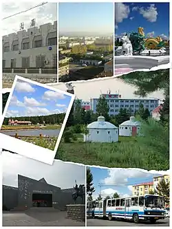
- Dayan Town
 Places in Dayan Town
 No.1 Colliery of Dayan in 1990s
 Winter of Dayan Town
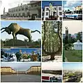
- The other Administrative Divisions in Evenk Banner
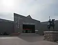 Ewenki Museum in the town of Bayan Toi
.jpg.webp) Honghuaerji National Forest Park
Honghuaerji National Forest Park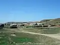 Bayintala Daur Township
References
- 鄂温克概况 (in Chinese). Ewenki Autonomous Banner People's Government. Archived from the original on 2020-05-31. Retrieved 2020-05-31.
- 2019年统计用区划代码 (in Chinese). National Bureau of Statistics of the People's Republic of China. Retrieved 2020-05-31.
- 鄂温克族自治旗概况地图 (in Chinese). XZQH.org. 2013-04-23. Retrieved 2020-05-31.
- 华能伊敏煤电有限责任公司-新华网. Xinhua. 2019-12-03. Archived from the original on 2020-05-31. Retrieved 2020-05-31.