Municipal District of Greenview No. 16
The Municipal District of Greenview No. 16 is a municipal district in northwest Alberta, Canada.
Municipal District of Greenview No. 16 | |
|---|---|
Municipal district | |
.jpg.webp) Municipal District of Greenview's administration building in Valleyview | |
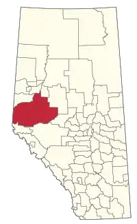 Location within Alberta | |
| Coordinates: 55°04′7″N 117°16′6″W | |
| Country | |
| Province | |
| Region | Northern Alberta |
| Census division | No. 18 |
| Established | 1994 |
| Government | |
| • Reeve | Dale Gervais |
| • Governing body | M.D. of Greenview Council |
| • Office location | Valleyview |
| Area (2016)[2] | |
| • Land | 32,984.24 km2 (12,735.29 sq mi) |
| Population (2016)[2] | |
| • Total | 5,583 |
| • Density | 0.2/km2 (0.5/sq mi) |
| Time zone | UTC-7 (MST) |
| Website | mdgreenview.ab.ca |
It covers the full extent of Census Division 18 and with an area of 32984.24 square kilometers; it is the third largest municipal district in Alberta. Its municipal office is located in the Town of Valleyview.
History
Human settlement of the area now forming Greenview occurred millennia ago with archaeological evidence of native peoples in the Grande Cache area dating back over 10,000 years.[3]
Modern settlement occurred predominately in the early twentieth century throughout the municipal district. Settlers and homesteaders followed various trails to found homesteads and early communities including DeBolt, Ridgevalley, and Grovedale. During the initial influx, the Edson to Grande Prairie Trail was a common route for many settlers reaching the north and east sections of Greenview.[4]
In 1968 three improvement districts, formerly 110,111 and 126, were conglomerated to establish Improvement District 16. As an Improvement District it was initially administered under Alberta's Department of Municipal Affairs. In 1996 Improvement District 16 became the Municipal District of Greenview #16 and was fully self-governed.[5]
In January 2019, the former Town of Grande Cache was dissolved, becoming a hamlet under the jurisdiction of Greenview.[6]
Geography
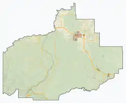
Greenview covers a landmass with an area of 32,984.24 square kilometres and contains several geographic formations. Its westernmost portion runs along the Alberta – British Columbia border and is part of the Canadian Rockies. Its northern portion is located in Peace Country while most of the south and interior is boreal forest. The Wapiti River makes up a portion of the boundary between the County of Grande Prairie No. 1 and Greenview which also includes the Simmonette, Smoky and Little Smoky River valleys. Numerous lakes are located in Greenview. Some of the most notable are Sturgeon, Musreau, and Swan Lake as well as a portion of Snipe Lake in its northeasternmost corner.
The Municipal district encompasses two other municipalities: the towns of Valleyview and Fox Creek as well as three reserves administered by the Sturgeon Lake Cree Nation. Greenview, in turn, is immediately neighboured by six municipalities, Wilmore Wilderness Park in the southwest and British Columbia.Grande Cache was formerly a third town within the M.D. until its dissolution. The town became a hamlet within Greenview on January 1, 2019.[7]
Lying on part of the Western Canadian Sedimentary Basin which includes some of the largest coal and oil deposits in the world, Greenview is well known for its oil and gas-rich geology. The Hamlet of DeBolt gives its name to the Debolt Formation. Geothermal reservoirs are also abundant in certain parts of the municipal district.[8]
Demographics
In the 2016 Census of Population conducted by Statistics Canada, the Municipal District of Greenview No. 16 recorded a population of 5,583 living in 2,067 of its 2,473 total private dwellings, a 5.4% change from its 2011 population of 5,299. With a land area of 32,984.24 km2 (12,735.29 sq mi), it had a population density of 0.2/km2 (0.4/sq mi) in 2016.[2]
The Municipal District of Greenview No. 16's 2013 municipal census counted a population of 5,242,[9] a -5% change from its 2000 municipal census population of 5,516.[10]
In the 2011 Census, the Municipal District of Greenview No. 16 had a population of 5,299 living in 1,970 of its 2,197 total dwellings, a -3% change from its 2006 population of 5,464. With a land area of 32,989.05 km2 (12,737.14 sq mi), it had a population density of 0.2/km2 (0.4/sq mi) in 2011.[11]
Economy
Oil and gas is the main economic driver in the Municipal District of Greenview, along with forestry and agriculture.[12]
Communities and localities
|
The following urban municipalities are surrounded by the Municipal District of Greenview No. 16:[13]
The following hamlets are located within the Municipal District of Greenview No. 16:[13]
|
The following localities are located within the Municipal District of Greenview No. 16:[14]
|
|
Attractions
- DeBolt and District Pioneer Museum
- Kakwa Wildlands Park
- Musreau Lake
- O'Brien Provincial Park
- Pierre Grey's Lakes Provincial Park
- Sturgeon Lake
- Willmore Wilderness Park
Government
Municipal Politics
The Municipal District of Greenview is governed in accordance with Alberta's Municipal Government Management Act (1995).[16] Residents elect 8 ward councillors every four years.[17]
Provincial Politics
Greenview is served by the Provincial Electoral Divisions of Grande Prairie – Smoky, Grande Prairie – Wapiti and, West Yellowhead. Following the 2015 Alberta general election the major provincial parties had one representative each.[18]
Federal Politics
Greenview is served by the Federal Electoral Divisions of Grande Prairie Mackenzie, Peace River- Westlock and Yellowhead. All three are currently represented by members of the Conservative Party.
Infrastructure
As part of the CANAMEX Corridor, the presence of Highway 43 within the municipal district makes Greenview an important industry travel route. The Bighorn Highway (Highway 40) as well as Highway 49 also play a large role in making the area a major transportation route for the north of the province. Several small airports and heliports are in the area including the Valleyview Airport, Fox Creek Airport and DeBolt Aerodrome. They predominately serve industry and medical facilities in the area with light aircraft.[19]
References
- "Municipal Officials Search". Alberta Municipal Affairs. September 22, 2017. Retrieved September 25, 2017.
- "Population and dwelling counts, for Canada, provinces and territories, and census subdivisions (municipalities), 2016 and 2011 censuses – 100% data (Alberta)". Statistics Canada. February 8, 2017. Retrieved February 8, 2017.
- "History". Aseniwuche Winewak Nation of Canada. Retrieved 13 July 2017.
- "Edson Trail and the Long Trail". Heritage of the Mighty Peace. Archived from the original on 8 December 2010. Retrieved 13 July 2017.CS1 maint: bot: original URL status unknown (link)
- "Municipal District of Greenview History". South Peace Regional Archives. Retrieved 13 July 2017.
- "No Big Changes Expected As Grande Cache Becomes Hamlet". My Grande Prairie Now. Retrieved 1 February 2019.
- "Media Release" (PDF). Municipal District of Greenview. Retrieved 1 February 2019.
- "Geothermal energy research in Alberta making strides with new technology". CBC News. Retrieved 1 August 2017.
- "2013 Census Newsletter" (PDF) (PDF). Municipal District of Greenview No. 16. Archived from the original (PDF) on December 15, 2013. Retrieved December 5, 2013.
- "2000 Official Population List" (PDF) (PDF). Alberta Municipal Affairs. September 1, 2000. Retrieved December 5, 2013.
- "Population and dwelling counts, for Canada, provinces and territories, and census subdivisions (municipalities), 2011 and 2006 censuses (Alberta)". Statistics Canada. February 8, 2012. Retrieved February 8, 2012.
- "Why Valleyview". Town of Valleyview. Retrieved 13 July 2017.
- "Specialized and Rural Municipalities and Their Communities" (PDF). Alberta Municipal Affairs. 2012-03-01. Archived from the original (PDF) on 2012-04-09. Retrieved 2012-08-11.
- "Standard Geographical Classification (SGC) 2006, Economic Regions: 4818015 - Greenview No. 16, geographical codes and localities, 2006". Statistics Canada. 2010-03-05. Retrieved 2012-08-11.
- "Ward 4: Sunset House & Sweathouse" (PDF) (PDF). Municipal District of Greenview No. 16. June 2, 2010. Retrieved June 30, 2014.
- Alberta Queen's Printer. "Municipal Government Act". Retrieved 3 August 2017.
- "2013 Election Results". Municipal District of Greenview No. 16. Retrieved 3 August 2017.
- "Alberta election 2015 results: From PC blue to NDP orange". CBC News. Retrieved 3 August 2017.
- "Airports Alberta, Canada". Our Airports. Retrieved 3 August 2017.
External links
Places adjacent to Municipal District of Greenview No. 16 | |
|---|---|