List of United Kingdom locations: Bab-Bal

This is part of the list of United Kingdom locations: a gazetteer of place names in the United Kingdom showing each place's locality and geographical coordinates.
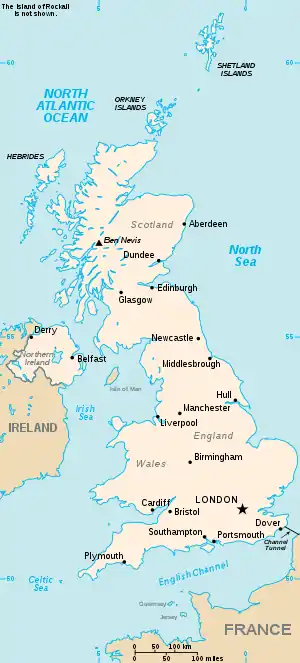
The United Kingdom

Bab

Location Locality Coordinates
(links to map & photo sources)
OS grid
reference
Babbacombe Devon 50.47°N 03.52°W / 50.47; -03.52 SX9265
Babbington Nottinghamshire 52.98°N 01.27°W / 52.98; -01.27 SK4943
Babbinswood Shropshire 52.86°N 02.99°W / 52.86; -02.99 SJ3330
Babbs Green Hertfordshire 51.82°N 00.01°E / 51.82; 00.01 TL3916
Babcary Somerset 51.04°N 02.62°W / 51.04; -02.62 ST5628
Babel Carmarthenshire 52.00°N 03.70°W / 52.00; -03.70 SN8335
Babel Green Suffolk 52.10°N 00.52°E / 52.10; 00.52 TL7348
Babell Flintshire 53.24°N 03.27°W / 53.24; -03.27 SJ1573
Babeny Devon 50.55°N 03.87°W / 50.55; -03.87 SX6775
Babingley Norfolk 52.81°N 00.48°E / 52.81; 00.48 TF6726
Babraham Cambridgeshire 52.12°N 00.20°E / 52.12; 00.20 TL5150
Babworth Nottinghamshire 53.31°N 00.98°W / 53.31; -00.98 SK6880

Bac

Location Locality Coordinates
(links to map & photo sources)
OS grid
reference
Bac Western Isles 58.27°N 06.30°W / 58.27; -06.30 NB4840
Bac Beag Argyll and Bute 56.44°N 06.48°W / 56.44; -06.48 NM239374
Bachau Isle of Anglesey 53.32°N 04.35°W / 53.32; -04.35 SH4383
Bache Shropshire 52.42°N 02.79°W / 52.42; -02.79 SO4681
Bacheldre Powys 52.52°N 03.12°W / 52.52; -03.12 SO2492
Bachelor's Bump East Sussex 50.87°N 00.61°E / 50.87; 00.61 TQ8412
Bache Mill Shropshire 52.46°N 02.73°W / 52.46; -02.73 SO5086
Bach-y-gwreiddyn Swansea 51.68°N 04.02°W / 51.68; -04.02 SN6000
Backaland Orkney Islands 59.15°N 02.77°W / 59.15; -02.77 HY5630
Backbarrow Cumbria 54.24°N 02.99°W / 54.24; -02.99 SD3584
Backbower Tameside 53.43°N 02.07°W / 53.43; -02.07 SJ9593
Backburn Aberdeenshire 57.39°N 02.78°W / 57.39; -02.78 NJ5334
Backe Carmarthenshire 51.80°N 04.52°W / 51.80; -04.52 SN2615
Backford Cheshire 53.23°N 02.91°W / 53.23; -02.91 SJ3971
Backford Cross Cheshire 53.25°N 02.93°W / 53.25; -02.93 SJ3873
Backhill Aberdeenshire 57.44°N 02.36°W / 57.44; -02.36 NJ7839
Backhill of Clackriach Aberdeenshire 57.50°N 02.13°W / 57.50; -02.13 NJ9246
Backhill of Fortrie Aberdeenshire 57.45°N 02.06°W / 57.45; -02.06 NJ9640
Backies Highland 57.99°N 03.98°W / 57.99; -03.98 NC8302
Backlands Moray 57.70°N 03.44°W / 57.70; -03.44 NJ1469
Backmuir of New Gilston Fife 56.26°N 02.92°W / 56.26; -02.92 NO4308
Back o'th' Brook Staffordshire 53.05°N 01.88°W / 53.05; -01.88 SK0851
Back Rogerton East Ayrshire 55.47°N 04.29°W / 55.47; -04.29 NS5522
Back Street Suffolk 52.19°N 00.54°E / 52.19; 00.54 TL7458
Backwell North Somerset 51.40°N 02.74°W / 51.40; -02.74 ST4868
Backwell Common North Somerset 51.41°N 02.74°W / 51.41; -02.74 ST4869
Backwell Green North Somerset 51.41°N 02.73°W / 51.41; -02.73 ST4969
Backworth North Tyneside 55.04°N 01.53°W / 55.04; -01.53 NZ3072
Bac Mor (Dutchmans Cap) Argyll and Bute 56.45°N 06.47°W / 56.45; -06.47 NM244385
Bacon End Essex 51.83°N 00.32°E / 51.83; 00.32 TL6018
Baconend Green Essex 51.84°N 00.32°E / 51.84; 00.32 TL6019
Bacon's End Solihull 52.48°N 01.75°W / 52.48; -01.75 SP1787
Baconsthorpe Norfolk 52.88°N 01.15°E / 52.88; 01.15 TG1237
Bacton Herefordshire 51.98°N 02.93°W / 51.98; -02.93 SO3632
Bacton Norfolk 52.84°N 01.47°E / 52.84; 01.47 TG3433
Bacton Suffolk 52.26°N 01.00°E / 52.26; 01.00 TM0567
Bacton Green Norfolk 52.85°N 01.47°E / 52.85; 01.47 TG3434
Bacton Green Suffolk 52.24°N 00.97°E / 52.24; 00.97 TM0365
Bacup Lancashire 53.69°N 02.21°W / 53.69; -02.21 SD8622

Bad

Location Locality Coordinates
(links to map & photo sources)
OS grid
reference
Badachonacher Highland 57.72°N 04.20°W / 57.72; -04.20 NH6973
Badbury Swindon 51.51°N 01.72°W / 51.51; -01.72 SU1980
Badbury Wick Swindon 51.52°N 01.74°W / 51.52; -01.74 SU1881
Badby Northamptonshire 52.21°N 01.18°W / 52.21; -01.18 SP5658
Badcall Highland 58.44°N 05.01°W / 58.44; -05.01 NC2455
Badcaul Highland 57.86°N 05.33°W / 57.86; -05.33 NH0291
Baddeley Edge City of Stoke-on-Trent 53.04°N 02.13°W / 53.04; -02.13 SJ9150
Baddeley Green City of Stoke-on-Trent 53.05°N 02.15°W / 53.05; -02.15 SJ9051
Baddesley Clinton Warwickshire 52.34°N 01.70°W / 52.34; -01.70 SP2072
Baddesley Ensor Warwickshire 52.57°N 01.60°W / 52.57; -01.60 SP2798
Baddidarach Highland 58.14°N 05.26°W / 58.14; -05.26 NC0822
Baddow Park Essex 51.69°N 00.48°E / 51.69; 00.48 TL7202
Badenscallie Highland 58.00°N 05.33°W / 58.00; -05.33 NC0306
Badenscoth Aberdeenshire 57.43°N 02.51°W / 57.43; -02.51 NJ6938
Badentoy Park Aberdeenshire 57.06°N 02.16°W / 57.06; -02.16 NO9097
Badgall Cornwall 50.64°N 04.50°W / 50.64; -04.50 SX2386
Badgeney Cambridgeshire 52.54°N 00.09°E / 52.54; 00.09 TL4296
Badger Shropshire 52.58°N 02.35°W / 52.58; -02.35 SO7699
Badgers Hill Worcestershire 52.13°N 02.00°W / 52.13; -02.00 SP0048
Badgers Mount Kent 51.33°N 00.13°E / 51.33; 00.13 TQ4962
Badger Street Somerset 50.96°N 03.05°W / 50.96; -03.05 ST2619
Badgeworth Gloucestershire 51.86°N 02.14°W / 51.86; -02.14 SO9019
Badgworth Somerset 51.26°N 02.87°W / 51.26; -02.87 ST3952
Badharlick Cornwall 50.64°N 04.46°W / 50.64; -04.46 SX2686
Badicaul Highland 57.29°N 05.73°W / 57.29; -05.73 NG7529
Badlesmere Kent 51.24°N 00.86°E / 51.24; 00.86 TR0053
Badluarach Highland 57.89°N 05.39°W / 57.89; -05.39 NG9994
Badminton South Gloucestershire 51.53°N 02.28°W / 51.53; -02.28 ST8082
Badnaban Highland 58.12°N 05.27°W / 58.12; -05.27 NC0720
Badnagie Highland 58.26°N 03.45°W / 58.26; -03.45 ND1531
Badninish Highland 57.91°N 04.09°W / 57.91; -04.09 NH7694
Badrallach Highland 57.86°N 05.27°W / 57.86; -05.27 NH0691
Badsey Worcestershire 52.08°N 01.89°W / 52.08; -01.89 SP0743
Badshalloch West Dunbartonshire 56.05°N 04.49°W / 56.05; -04.49 NS4587
Badshot Lea Surrey 51.22°N 00.76°W / 51.22; -00.76 SU8648
Badsworth Wakefield 53.62°N 01.30°W / 53.62; -01.30 SE4614
Badwell Ash Suffolk 52.28°N 00.91°E / 52.28; 00.91 TL9969
Badwell Green Suffolk 52.28°N 00.94°E / 52.28; 00.94 TM0169
Badworthy Devon 50.43°N 03.86°W / 50.43; -03.86 SX6861

Bae-Bag

Location Locality Coordinates
(links to map & photo sources)
OS grid
reference
Bae Cinmel (Kinmel Bay) Conwy 53.30°N 03.53°W / 53.30; -03.53 SH9880
Bae Colwyn (Colwyn Bay) Conwy 53.28°N 03.71°W / 53.28; -03.71 SH8678
Bae-Penrhyn (Penrhyn Bay) Conwy 53.31°N 03.77°W / 53.31; -03.77 SH8281
Baffins City of Portsmouth 50.80°N 01.06°W / 50.80; -01.06 SU6601
Bagber Dorset 50.91°N 02.35°W / 50.91; -02.35 ST7513
Bagby North Yorkshire 54.21°N 01.29°W / 54.21; -01.29 SE4680
Bagby Grange North Yorkshire 54.21°N 01.31°W / 54.21; -01.31 SE4580
Bag Enderby Lincolnshire 53.22°N 00.01°E / 53.22; 00.01 TF3472
Bagendon Gloucestershire 51.75°N 01.98°W / 51.75; -01.98 SP0106
Bagginswood Shropshire 52.42°N 02.47°W / 52.42; -02.47 SO6881
Baggrow Cumbria 54.75°N 03.29°W / 54.75; -03.29 NY1741
Baggy Point Devon 51.14°N 04.25°W / 51.14; -04.25 SS426403
Bagham Kent 51.23°N 00.96°E / 51.23; 00.96 TR0753
Bagh Mor Western Isles 57.48°N 07.22°W / 57.48; -07.22 NF8756
Bagillt Flintshire 53.26°N 03.17°W / 53.26; -03.17 SJ2275
Baginton Warwickshire 52.36°N 01.50°W / 52.36; -01.50 SP3474
Baglan Neath Port Talbot 51.61°N 03.80°W / 51.61; -03.80 SS7592
Bagley Leeds 53.81°N 01.66°W / 53.81; -01.66 SE2235
Bagley Somerset 51.20°N 02.78°W / 51.20; -02.78 ST4545
Bagley Shropshire 52.83°N 02.89°W / 52.83; -02.89 SJ4027
Bagley Green Somerset 50.96°N 03.25°W / 50.96; -03.25 ST1219
Bagley Marsh Shropshire 52.84°N 02.90°W / 52.84; -02.90 SJ3928
Bagmore Hampshire 51.19°N 01.05°W / 51.19; -01.05 SU6644
Bagnall Staffordshire 53.04°N 02.12°W / 53.04; -02.12 SJ9250
Bagnor Berkshire 51.41°N 01.35°W / 51.41; -01.35 SU4569
Bagpath (Kingscote) Gloucestershire 51.64°N 02.29°W / 51.64; -02.29 ST8094
Bagpath (Rodborough) Gloucestershire 51.71°N 02.21°W / 51.71; -02.21 SO8502
Bagshaw Derbyshire 53.32°N 01.89°W / 53.32; -01.89 SK0781
Bagshot Wiltshire 51.38°N 01.55°W / 51.38; -01.55 SU3165
Bagshot Surrey 51.35°N 00.69°W / 51.35; -00.69 SU9163
Bagshot Heath Surrey 51.34°N 00.69°W / 51.34; -00.69 SU9161
Bagslate Moor Rochdale 53.61°N 02.21°W / 53.61; -02.21 SD8613
Bagstone South Gloucestershire 51.58°N 02.46°W / 51.58; -02.46 ST6887
Bagthorpe Nottinghamshire 53.05°N 01.30°W / 53.05; -01.30 SK4751
Bagthorpe Norfolk 52.85°N 00.65°E / 52.85; 00.65 TF7932
Baguley Manchester 53.39°N 02.28°W / 53.39; -02.28 SJ8189
Bagworth Leicestershire 52.66°N 01.35°W / 52.66; -01.35 SK4408
Bagwyllydiart Herefordshire 51.92°N 02.81°W / 51.92; -02.81 SO4426

Bai

Location Locality Coordinates
(links to map & photo sources)
OS grid
reference
Bailanloan Perth and Kinross 56.77°N 03.86°W / 56.77; -03.86 NN8666
Bailbrook Bath and North East Somerset 51.40°N 02.34°W / 51.40; -02.34 ST7667
Baildon Bradford 53.84°N 01.77°W / 53.84; -01.77 SE1539
Baildon Green Bradford 53.83°N 01.78°W / 53.83; -01.78 SE1438
Baile Ailein Western Isles 58.08°N 06.60°W / 58.08; -06.60 NB2920
Baile an Truiseil Western Isles 58.38°N 06.50°W / 58.38; -06.50 NB3753
Baile Boidheach Argyll and Bute 55.89°N 05.61°W / 55.89; -05.61 NR7473
Baile Gharbhaidh Western Isles 57.38°N 07.39°W / 57.38; -07.39 NF7646
Baile Glas Western Isles 57.49°N 07.27°W / 57.49; -07.27 NF8457
Baile Mhanaich Western Isles 57.47°N 07.39°W / 57.47; -07.39 NF7755
Baile Mòr Argyll and Bute 56.33°N 06.40°W / 56.33; -06.40 NM2824
Baile nan Cailleach Western Isles 57.45°N 07.38°W / 57.45; -07.38 NF7753
Bailetonach Highland 56.78°N 05.88°W / 56.78; -05.88 NM6373
Bailey Green Hampshire 51.03°N 01.05°W / 51.03; -01.05 SU6627
Bailiff Bridge Calderdale 53.71°N 01.78°W / 53.71; -01.78 SE1424
Bail' Iochdrach Western Isles 57.50°N 07.32°W / 57.50; -07.32 NF8159
Baillieston City of Glasgow 55.84°N 04.12°W / 55.84; -04.12 NS6763
Bailrigg Lancashire 54.01°N 02.79°W / 54.01; -02.79 SD4858
Bail' Ùr Tholastaidh Western Isles 58.35°N 06.22°W / 58.35; -06.22 NB5348
Bainbridge North Yorkshire 54.30°N 02.10°W / 54.30; -02.10 SD9390
Bainsford Falkirk 56.01°N 03.79°W / 56.01; -03.79 NS8882
Bainshole Aberdeenshire 57.40°N 02.66°W / 57.40; -02.66 NJ6035
Bainton Cambridgeshire 52.64°N 00.39°W / 52.64; -00.39 TF0906
Bainton East Riding of Yorkshire 53.95°N 00.53°W / 53.95; -00.53 SE9652
Bainton Oxfordshire 51.92°N 01.15°W / 51.92; -01.15 SP5826
Baintown Fife 56.21°N 03.04°W / 56.21; -03.04 NO3503
Bairnkine Scottish Borders 55.42°N 02.55°W / 55.42; -02.55 NT6515

Bak

Location Locality Coordinates
(links to map & photo sources)
OS grid
reference
Baker's Cross Kent 51.08°N 00.54°E / 51.08; 00.54 TQ7835
Bakers End Hertfordshire 51.82°N 00.01°E / 51.82; 00.01 TL3916
Baker's Hill Gloucestershire 51.79°N 02.61°W / 51.79; -02.61 SO5811
Baker Street Essex 51.50°N 00.34°E / 51.50; 00.34 TQ6381
Baker's Wood Buckinghamshire 51.57°N 00.52°W / 51.57; -00.52 TQ0287
Bakesdown Cornwall 50.77°N 04.49°W / 50.77; -04.49 SS2400
Bakestone Moor Derbyshire 53.27°N 01.22°W / 53.27; -01.22 SK5276
Bakewell Derbyshire 53.20°N 01.68°W / 53.20; -01.68 SK2168

Bal

Location Locality Coordinates
(links to map & photo sources)
OS grid
reference
Bala Gwynedd 52.91°N 03.60°W / 52.91; -03.60 SH9236
Balance Hill Staffordshire 52.88°N 01.88°W / 52.88; -01.88 SK0832
Balavil Highland 57.09°N 03.99°W / 57.09; -03.99 NH7902
Balbeg Highland 57.34°N 04.57°W / 57.34; -04.57 NH4531
Balbeggie Perth and Kinross 56.44°N 03.36°W / 56.44; -03.36 NO1629
Balblair Highland 57.47°N 04.50°W / 57.47; -04.50 NH5045
Balblair (Cromarty Firth) Highland 57.66°N 04.18°W / 57.66; -04.18 NH7066
Balblair Aberdeenshire 57.14°N 02.49°W / 57.14; -02.49 NJ7006
Balbuthie Fife 56.20°N 02.80°W / 56.20; -02.80 NO5002
Balby Doncaster 53.50°N 01.17°W / 53.50; -01.17 SE5501
Balcary Point Dumfries and Galloway 54.82°N 03.83°W / 54.82; -03.83 NX820494
Balcathie Angus 56.54°N 02.65°W / 56.54; -02.65 NO6039
Balchladich Highland 58.21°N 05.35°W / 58.21; -05.35 NC0330
Balchraggan (The Aird) Highland 57.45°N 04.45°W / 57.45; -04.45 NH5343
Balchraggan (Loch Ness) Highland 57.37°N 04.39°W / 57.37; -04.39 NH5634
Balchrick Highland 58.48°N 05.10°W / 58.48; -05.10 NC1959
Balcombe West Sussex 51.05°N 00.13°W / 51.05; -00.13 TQ3130
Balcombe Lane West Sussex 51.07°N 00.13°W / 51.07; -00.13 TQ3132
Balcurvie Fife 56.18°N 03.06°W / 56.18; -03.06 NO3400
Baldersby North Yorkshire 54.19°N 01.46°W / 54.19; -01.46 SE3578
Baldersby St James North Yorkshire 54.17°N 01.44°W / 54.17; -01.44 SE3676
Balderstone Lancashire 53.78°N 02.56°W / 53.78; -02.56 SD6332
Balderstone Rochdale 53.59°N 02.15°W / 53.59; -02.15 SD9011
Balderton Nottinghamshire 53.05°N 00.79°W / 53.05; -00.79 SK8151
Balderton Cheshire 53.15°N 02.94°W / 53.15; -02.94 SJ3762
Baldhoon Isle of Man 54.22°N 04.44°W / 54.22; -04.44 SC4184
Baldhu Cornwall 50.23°N 05.12°W / 50.23; -05.12 SW7742
Baldingstone Bury 53.62°N 02.30°W / 53.62; -02.30 SD8014
Baldinnie Fife 56.28°N 02.93°W / 56.28; -02.93 NO4211
Baldock Hertfordshire 51.98°N 00.19°W / 51.98; -00.19 TL2433
Baldon Row Oxfordshire 51.69°N 01.19°W / 51.69; -01.19 SP5600
Baldovie City of Dundee 56.48°N 02.89°W / 56.48; -02.89 NO4533
Baldrine Isle of Man 54.20°N 04.42°W / 54.20; -04.42 SC4281
Baldslow East Sussex 50.88°N 00.54°E / 50.88; 00.54 TQ7913
Baldwin Isle of Man 54.19°N 04.53°W / 54.19; -04.53 SC3581
Baldwinholme Cumbria 54.84°N 03.04°W / 54.84; -03.04 NY3351
Baldwin's Gate Staffordshire 52.94°N 02.31°W / 52.94; -02.31 SJ7939
Baldwins Hill West Sussex 51.13°N 00.02°W / 51.13; -00.02 TQ3839
Bale Norfolk 52.88°N 00.98°E / 52.88; 00.98 TG0136
Balemartine Argyll and Bute 56.46°N 06.90°W / 56.46; -06.90 NL9841
Balemore Western Isles 57.57°N 07.47°W / 57.57; -07.47 NF7367
Balephetrish Argyll and Bute 56.51°N 06.87°W / 56.51; -06.87 NM0046
Balephuil Argyll and Bute 56.45°N 06.95°W / 56.45; -06.95 NL9540
Balerno City of Edinburgh 55.88°N 03.34°W / 55.88; -03.34 NT1666
Baleromindubh Glac Mhor Argyll and Bute 56.04°N 06.20°W / 56.04; -06.20 NR3892
Baleshare Western Isles 57.52°N 07.37°W / 57.52; -07.37 NF787614
Balevullin Argyll and Bute 56.50°N 06.95°W / 56.50; -06.95 NL9546
Balfield Angus 56.80°N 02.75°W / 56.80; -02.75 NO5468
Balfour Orkney Islands 59.02°N 02.92°W / 59.02; -02.92 HY4716
Balfron Stirling 56.06°N 04.34°W / 56.06; -04.34 NS5488
Balfron Station Stirling 56.07°N 04.37°W / 56.07; -04.37 NS5289
Balgaveny Aberdeenshire 57.44°N 02.58°W / 57.44; -02.58 NJ6540
Balgonar Fife 56.12°N 03.57°W / 56.12; -03.57 NT0293
Balgowan Highland 57.01°N 04.25°W / 57.01; -04.25 NN6394
Balgowan Point Dumfries and Galloway 54.73°N 04.92°W / 54.73; -04.92 NX121418
Balgown (Trotternish) Highland 57.62°N 06.39°W / 57.62; -06.39 NG3868
Balgown (Struan) Highland 57.35°N 06.42°W / 57.35; -06.42 NG3438
Balgrochan East Dunbartonshire 55.97°N 04.21°W / 55.97; -04.21 NS6278
Balgunearie Highland 57.51°N 04.32°W / 57.51; -04.32 NH6149
Balgunloune Highland 57.50°N 04.30°W / 57.50; -04.30 NH6248
Balhalgardy Aberdeenshire 57.29°N 02.39°W / 57.29; -02.39 NJ7623
Balham Wandsworth 51.44°N 00.15°W / 51.44; -00.15 TQ2873
Baliasta Shetland Islands 60.76°N 00.90°W / 60.76; -00.90 HP6009
Baligrundle Argyll and Bute 56.50°N 05.52°W / 56.50; -05.52 NM8340
Balimore Argyll and Bute 55.90°N 05.68°W / 55.90; -05.68 NR7074
Balinoe Argyll and Bute 56.47°N 06.92°W / 56.47; -06.92 NL9742
Balintore Highland 57.75°N 03.91°W / 57.75; -03.91 NH8675
Balintore Angus 56.71°N 03.17°W / 56.71; -03.17 NO2859
Balintraid Highland 57.70°N 04.13°W / 57.70; -04.13 NH7370
Balkeerie Angus 56.58°N 03.10°W / 56.58; -03.10 NO3244
Balk Field Nottinghamshire 53.32°N 00.93°W / 53.32; -00.93 SK7181
Balkholme East Riding of Yorkshire 53.73°N 00.81°W / 53.73; -00.81 SE7827
Balkiellie Angus 56.67°N 02.49°W / 56.67; -02.49 NO7054
Ball Cornwall 50.52°N 04.82°W / 50.52; -04.82 SX0073
Ball Shropshire 52.82°N 03.04°W / 52.82; -03.04 SJ3026
Balla Western Isles 57.07°N 07.31°W / 57.07; -07.31 NF7811
Ballabeg Isle of Man 54.09°N 04.69°W / 54.09; -04.69 SC2470
Ballabeg Isle of Man 54.20°N 04.42°W / 54.20; -04.42 SC4282
Ballacannell Isle of Man 54.21°N 04.40°W / 54.21; -04.40 SC4382
Ballacarnane Beg Isle of Man 54.25°N 04.61°W / 54.25; -04.61 SC3088
Ballachrink Isle of Man 54.36°N 04.40°W / 54.36; -04.40 SC4499
Ballachulish Highland 56.67°N 05.13°W / 56.67; -05.13 NN0858
Balladen Lancashire 53.68°N 02.30°W / 53.68; -02.30 SD8021
Ballagawne Isle of Man 54.08°N 04.73°W / 54.08; -04.73 SC2169
Ballajora Isle of Man 54.28°N 04.35°W / 54.28; -04.35 SC4790
Ballaleigh Isle of Man 54.26°N 04.59°W / 54.26; -04.59 SC3189
Ballamodha Isle of Man 54.12°N 04.64°W / 54.12; -04.64 SC2773
Ballantrae South Ayrshire 55.09°N 05.01°W / 55.09; -05.01 NX0882
Ballaragh Isle of Man 54.23°N 04.38°W / 54.23; -04.38 SC4585
Ballard's Ash Wiltshire 51.55°N 01.91°W / 51.55; -01.91 SU0684
Ballards Gore Essex 51.59°N 00.74°E / 51.59; 00.74 TQ9092
Ballard's Green Warwickshire 52.51°N 01.60°W / 52.51; -01.60 SP2791
Ballasalla Isle of Man 54.09°N 04.63°W / 54.09; -04.63 SC2870
Ballater Aberdeenshire 57.04°N 03.05°W / 57.04; -03.05 NO3695
Ballaterson Isle of Man 54.30°N 04.33°W / 54.30; -04.33 SC4892
Ballaugh Isle of Man 54.30°N 04.55°W / 54.30; -04.55 SC3493
Balleigh Highland 57.82°N 04.19°W / 57.82; -04.19 NH7084
Ballelby Isle of Man 54.16°N 04.72°W / 54.16; -04.72 SC2278
Ballencrieff East Lothian 55.99°N 02.83°W / 55.99; -02.83 NT4878
Ballencrieff Toll West Lothian 55.91°N 03.64°W / 55.91; -03.64 NS9770
Ballentoul Perth and Kinross 56.76°N 03.83°W / 56.76; -03.83 NN8865
Ball Green City of Stoke-on-Trent 53.06°N 02.16°W / 53.06; -02.16 SJ8952
Ball Haye Green Staffordshire 53.11°N 02.03°W / 53.11; -02.03 SJ9857
Ballhill Devon 50.98°N 04.48°W / 50.98; -04.48 SS2624
Ball Hill Hampshire 51.36°N 01.39°W / 51.36; -01.39 SU4263
Ballidon Derbyshire 53.08°N 01.70°W / 53.08; -01.70 SK2054
Ballifeary Highland 57.46°N 04.23°W / 57.46; -04.23 NH6644
Ballimore (Loch Fyne) Argyll and Bute 55.99°N 05.33°W / 55.99; -05.33 NR9283
Ballimore (Loch Tromlee) Argyll and Bute 56.37°N 05.15°W / 56.37; -05.15 NN0525
Ballingdon Suffolk 52.02°N 00.71°E / 52.02; 00.71 TL8640
Ballingdon Bottom Hertfordshire 51.81°N 00.50°W / 51.81; -00.50 TL0314
Ballinger Bottom Buckinghamshire 51.71°N 00.68°W / 51.71; -00.68 SP9103
Ballinger Bottom (South) Buckinghamshire 51.70°N 00.68°W / 51.70; -00.68 SP9102
Ballinger Common Buckinghamshire 51.71°N 00.68°W / 51.71; -00.68 SP9103
Ballingham Herefordshire 51.97°N 02.62°W / 51.97; -02.62 SO5731
Ballingham Hill Herefordshire 51.98°N 02.62°W / 51.98; -02.62 SO5732
Ballingry Fife 56.15°N 03.33°W / 56.15; -03.33 NT1797
Ballinluig (SE of Pitlochry) Perth and Kinross 56.64°N 03.68°W / 56.64; -03.68 NN9752
Ballinluig (Pitlochry) Perth and Kinross 56.69°N 03.73°W / 56.69; -03.73 NN9457
Ballintuim Perth and Kinross 56.66°N 03.47°W / 56.66; -03.47 NO1054
Balliveolan Argyll and Bute 56.52°N 05.51°W / 56.52; -05.51 NM8442
Balloan Highland 58.01°N 04.38°W / 58.01; -04.38 NC5905
Balloch Highland 57.48°N 04.12°W / 57.48; -04.12 NH7346
Balloch North Lanarkshire 55.94°N 04.03°W / 55.94; -04.03 NS7374
Balloch West Dunbartonshire 56.00°N 04.58°W / 56.00; -04.58 NS3982
Ballochan Aberdeenshire 56.99°N 02.79°W / 56.99; -02.79 NO5290
Ballochearn Stirling 56.06°N 04.28°W / 56.06; -04.28 NS5888
Ballochgoy Argyll and Bute 55.83°N 05.06°W / 55.83; -05.06 NS0864
Balloch Lane South Ayrshire 55.21°N 04.47°W / 55.21; -04.47 NX428940
Ball o' Ditton Cheshire 53.36°N 02.76°W / 53.36; -02.76 SJ4986
Ballogie Aberdeenshire 57.04°N 02.71°W / 57.04; -02.71 NO5795
Balls Cross West Sussex 51.02°N 00.60°W / 51.02; -00.60 SU9826
Balls Green East Sussex 51.10°N 00.12°E / 51.10; 00.12 TQ4936
Balls Green West Sussex 50.99°N 00.43°W / 50.99; -00.43 TQ1023
Balls Green Essex 51.86°N 01.03°E / 51.86; 01.03 TM0923
Ball's Green Gloucestershire 51.68°N 02.20°W / 51.68; -02.20 ST8699
Balls Hill Sandwell 52.53°N 02.01°W / 52.53; -02.01 SO9993
Ballygown Argyll and Bute 56.50°N 06.17°W / 56.50; -06.17 NM4343
Ballygrant Argyll and Bute 55.81°N 06.16°W / 55.81; -06.16 NR3966
Ballymeanoch Argyll and Bute 56.10°N 05.49°W / 56.10; -05.49 NR8396
Balmacara Highland 57.28°N 05.63°W / 57.28; -05.63 NG8127
Balmacara Square Highland 57.29°N 05.65°W / 57.29; -05.65 NG8028
Balmaclellan Dumfries and Galloway 55.08°N 04.11°W / 55.08; -04.11 NX6579
Balmacneil Perth and Kinross 56.63°N 03.68°W / 56.63; -03.68 NN9750
Balmacqueen Highland 57.68°N 06.29°W / 57.68; -06.29 NG4474
Balmaha Stirling 56.07°N 04.54°W / 56.07; -04.54 NS4290
Balmalcolm Fife 56.26°N 03.09°W / 56.26; -03.09 NO3208
Balmalloch North Lanarkshire 55.97°N 04.08°W / 55.97; -04.08 NS7078
Balmartin Western Isles 57.62°N 07.49°W / 57.62; -07.49 NF7273
Balmashanner Angus 56.63°N 02.88°W / 56.63; -02.88 NO4649
Balmeanach (Staffin, Skye) Highland 57.63°N 06.25°W / 57.63; -06.25 NG4668
Balmeanach (Loch Caroy, Skye) Highland 57.39°N 06.46°W / 57.39; -06.46 NG3243
Balmeanach (Loch Sligachan, Skye) Highland 57.32°N 06.12°W / 57.32; -06.12 NG5234
Balmedie Aberdeenshire 57.24°N 02.06°W / 57.24; -02.06 NJ9617
Balmer Shropshire 52.90°N 02.83°W / 52.90; -02.83 SJ4434
Balmer Heath Shropshire 52.90°N 02.83°W / 52.90; -02.83 SJ4434
Balmerino Fife 56.40°N 03.05°W / 56.40; -03.05 NO3524
Balmerlawn Hampshire 50.82°N 01.57°W / 50.82; -01.57 SU3003
Balmichael North Ayrshire 55.52°N 05.29°W / 55.52; -05.29 NR9231
Balmoral (Galashiels) Scottish Borders 55.61°N 02.82°W / 55.61; -02.82 NT4836
Balmore (Caithness) Highland 58.58°N 03.72°W / 58.58; -03.72 ND0067
Balmore (Skye) Highland 57.37°N 06.52°W / 57.37; -06.52 NG2841
Balmore East Dunbartonshire 55.93°N 04.24°W / 55.93; -04.24 NS6073
Balmullo Fife 56.36°N 02.94°W / 56.36; -02.94 NO4220
Balnabodach Western Isles 56.98°N 07.41°W / 56.98; -07.41 NF7101
Balnaboth Angus 56.78°N 03.13°W / 56.78; -03.13 NO3166
Balnabruach Highland 57.83°N 03.85°W / 57.83; -03.85 NH9084
Balnabruich Highland 58.24°N 03.44°W / 58.24; -03.44 ND1529
Balnacoil Highland 58.07°N 04.03°W / 58.07; -04.03 NC8011
Balnacra Highland 57.45°N 05.36°W / 57.45; -05.36 NG9846
Balnadelson Highland 58.02°N 04.37°W / 58.02; -04.37 NC6006
Balnagask City of Aberdeen 57.12°N 02.06°W / 57.12; -02.06 NJ9604
Balnaguard Perth and Kinross 56.63°N 03.73°W / 56.63; -03.73 NN9451
Balnahard (Colonsay) Argyll and Bute 56.11°N 06.16°W / 56.11; -06.16 NR4199
Balnahard (Mull) Argyll and Bute 56.42°N 06.13°W / 56.42; -06.13 NM4534
Balnain Highland 57.33°N 04.59°W / 57.33; -04.59 NH4430
Balnakeil| Highland 58.57°N 04.77°W / 58.57; -04.77 NC3968
Balnakeil Craft Village Highland 58.56°N 04.76°W / 58.56; -04.76 NC3967
Balnakilly Perth and Kinross 56.72°N 03.52°W / 56.72; -03.52 NO0760
Balnaknock Highland 57.57°N 06.31°W / 57.57; -06.31 NG4262
Balnamoon Aberdeenshire 57.58°N 02.18°W / 57.58; -02.18 NJ8955
Balnamoon Angus 56.75°N 02.73°W / 56.75; -02.73 NO5563
Balnapaling Highland 57.69°N 04.03°W / 57.69; -04.03 NH7969
Balne North Yorkshire 53.66°N 01.12°W / 53.66; -01.12 SE5819
Balornock City of Glasgow 55.88°N 04.20°W / 55.88; -04.20 NS6268
Balquhidder Stirling 56.35°N 04.38°W / 56.35; -04.38 NN5320
Balranald Western Isles 57.60°N 07.49°W / 57.60; -07.49 NF7270
Balsall Solihull 52.38°N 01.66°W / 52.38; -01.66 SP2376
Balsall Common Solihull 52.39°N 01.66°W / 52.39; -01.66 SP2377
Balsall Heath Birmingham 52.45°N 01.89°W / 52.45; -01.89 SP0784
Balsall Street Solihull 52.38°N 01.67°W / 52.38; -01.67 SP2276
Balscote Oxfordshire 52.06°N 01.43°W / 52.06; -01.43 SP3941
Balsham Cambridgeshire 52.12°N 00.30°E / 52.12; 00.30 TL5850
Balstonia Essex 51.52°N 00.43°E / 51.52; 00.43 TQ6983
Balta Shetland Islands 60.74°N 00.79°W / 60.74; -00.79 HP658075
Baltasound Shetland Islands 60.75°N 00.86°W / 60.75; -00.86 HP6208
Balterley Staffordshire 53.04°N 02.35°W / 53.04; -02.35 SJ7650
Balterley Green Staffordshire 53.04°N 02.35°W / 53.04; -02.35 SJ7650
Balterley Heath Cheshire 53.04°N 02.38°W / 53.04; -02.38 SJ7450
Balthangie Aberdeenshire 57.54°N 02.28°W / 57.54; -02.28 NJ8351
Baltilly Fife 56.28°N 02.98°W / 56.28; -02.98 NO3911
Baltonsborough Somerset 51.10°N 02.65°W / 51.10; -02.65 ST5434
Balvenie Moray 57.46°N 03.13°W / 57.46; -03.13 NJ3242
Balvicar Argyll and Bute 56.28°N 05.62°W / 56.28; -05.62 NM7616
Balvraid Highland 57.52°N 04.50°W / 57.52; -04.50 NH5051
Balwest Cornwall 50.12°N 05.37°W / 50.12; -05.37 SW5930
This article is issued from Wikipedia. The text is licensed under Creative Commons - Attribution - Sharealike. Additional terms may apply for the media files.