List of power stations in New Mexico
This is a list of electricity-generating power stations in the U.S. state of New Mexico, sorted by type and name. In 2019, New Mexico had a total summer capacity of 8,770 MW through all of its power plants, and a net generation of 35,175 GWh.[2] The corresponding electrical energy generation mix was 41.8% coal, 33.6% natural gas, 19.6% wind, and 3.9% solar PV. Petroleum, biomass, geothermal and hydroelectric each generated less than a 0.5% share.[1]
Sources of New Mexico electricity generation: full-year 2019 [1]
Small-scale solar including customer-owned photovoltaic panels delivered an additional net 301 GWh to New Mexico's electricity grid in 2019. This was less than one-quarter of the amount generated by the state's utility-scale photovoltaic plants.[1]
New Mexico hosts the nation's only long-term underground repository for waste from nuclear weapons research and production, the Waste Isolation Pilot Plant near Carlsbad. Extraction of the state's nearby Permian Basin oil reserves for transportation and other uses rose to the nation's third highest, contributing 6% of total U.S. production in 2018.[3] New Mexico's oil extraction included the flaring of over 35 billion cubic feet of associated petroleum gas in each of the years 2018 and 2019.[4] This amount of wasted natural gas could have generated about 5,000 GWh of electrical energy, an amount equal to 14% of the state's total annual generation.[5]
Fossil-fuel power stations
Data from the U.S. Energy Information Administration serves as a general reference.[6]
Coal
| Name | Image | Location | Coordinates | Capacity (MW) |
Year Opened |
Scheduled Retirement | Ref |
|---|---|---|---|---|---|---|---|
| Four Corners Generating Station | 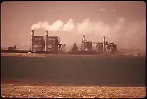 |
San Juan County | 36°41′24″N 108°28′53″W | 1,636 | 1969 (Unit 4) 1970 (Unit 5) |
Units 1, 2 & 3 CLOSED 2013
Unit 4 & 5 - 2031 |
[7][8][9] |
| San Juan Generating Station |  |
San Juan County | 36°48′02″N 108°26′19″W | 924 | 1973 (Unit 1) 1982 (Unit 4) |
Units 2 and 3 CLOSED 2017
Units 1 and 4 retiring in 2022 |
[10][11][12] |
| Escalante Generating Station | McKinley County | 35°24′57″N 108°04′55″W | 257 | 1984 | CLOSED Aug 2020 | [13][14][15][16] | |
Petroleum
| Name | Location | Coordinates | Capacity (MW) |
Generation Type |
Operator | Year Opened |
Ref | Note |
|---|---|---|---|---|---|---|---|---|
| Freeport McMoRan | Grant County | 32.6618°N 108.3628°W | 30.5 | Reciprocating Engine (x10) | Public Service Co of NM | 1967/1972 | ||
| Quay County | Quay County | 35.1828°N 103.7311°W | 27 | Simple Cycle | Southwestern Public Service | 2013 | ||
Natural gas
| Name | Location | Coordinates | Capacity (MW) |
Generation Type |
Operator | Year Opened |
Ref | Note |
|---|---|---|---|---|---|---|---|---|
| Afton | Dona Ana County | 32.1142°N 106.8465°W | 287 | 1x1 Combined Cycle | Public service Co of NM | 2002/2007 | ||
| Algodones | Sandoval County | 35.3844°N 106.4642°W | 45 | Steam Turbine (x3) | Public Service Co of NM | 1954/1959 | ||
| Animas | San Juan County | 36.7251°N 108.1920°W | 18 | Simple Cycle | City of Farmington | 1994 | ||
| Bluffview | San Juan County | 36.7166°N 108.2153°W | 67 | 1x1 Combined Cycle | City of Farmington | 2005 | ||
| Chino Hurley Mines | Grant County | 32.6956°N 108.1225°W | 54 | 1x1 Combined Cycle | Freeport McMoRan Corp | 1959/2001 | ||
| Cunningham | Lea County | 32.7131°N 103.3533°W | 519 | Steam Turbine (x2), Simple Cycle (x2) |
Southwestern Public Service Co | 1957/1965/ 1998 |
||
| Ford Utilities | Bernalillo County | 35.0841°N 106.6252°W | 13.7 | Simple Cycle (x2) | University of New Mexico | 2005/2014 | ||
| Hobbs | Lea County | 32.7283°N 103.3094°W | 665 | 2x1 Combined Cycle, Simple Cycle |
Lea Power Partners | 2008 | ||
| La Luz | Valencia County | 34.6161°N 106.8150°W | 42.3 | Simple Cycle | Public Service Co of NM | 2015 | ||
| LCEC Generation | Lea County | 32.9781°N 103.3239°W | 46.5 | Reciprocating Engine (x5) | Western Farmers Elec Coop, Inc | 2012 | ||
| Lordsburg | Hidalgo County | 32.3505°N 108.6980°W | 88 | Simple Cycle (x2) | Public Service Co of NM | 2002 | ||
| Luna | Luna County | 32.2993°N 107.7834°W | 650 | 2x1 Combined Cycle | Public Service Co of NM | 2006 | ||
| Maddox | Lea County | 32.7142°N 103.3015°W | 212 | Steam Turbine, Simple Cycle (x2) |
Southwestern Public Service Co | 1963/1967/ 1976 |
||
| Pyramid | Hidalgo County | 32.2363°N 108.5494°W | 186 | Simple Cycle (x4) | Tri-State G & T Assn, Inc | 2003 | ||
| Reeves | Bernalillo County | 35.1710°N 106.6019°W | 154 | Steam Turbine (x3) | Public Service Co of NM | 1960/1962 | ||
| Rio Bravo | Bernalillo County | 35.0260°N 106.6440°W | 150 | Simple Cycle | Public Service Co of NM | 2000 | ||
| Rio Grande | Dona Ana County | 31.8047°N 106.5472°W | 372 | Steam Turbine (x3), Simple Cycle |
El Paso Electric Co | 1957/1958/1972/2013 | ||
| Valencia | Valencia County | 34.6115°N 106.7322°W | 159.5 | Simple Cycle | Valencia Power LLC | 2008 | ||
Renewable power stations
Data from the U.S. Energy Information Administration serves as a general reference.[6]
Geothermal
| Name | Location | Coordinates | Capacity (MW) |
Operator | Year Opened |
Ref | Note |
|---|---|---|---|---|---|---|---|
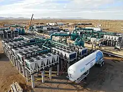
| Lightning Dock | Animas, New Mexico | 32.1447°N 108.8383°W | 4.0 | Cyrq Energy | 2014 | [17][18][19][20] |
Biomass
| Name | Location | Coordinates | Capacity (MW) |
Generation Type |
Fuel | Operator | Year Opened |
Ref | Note |
|---|---|---|---|---|---|---|---|---|---|
| Four Peaks Camino Real | Dona Ana County | 31.8111°N 106.5933°W | 3.2 | Reciprocating Engine (x2) | landfill gas | ENERGYneering Solutions | 2008 | ||
| Southside Water Reclamation | Bernalillo County | 35.0161°N 106.6697°W | 2.2 | Reciprocating Engine (x2) | wastewater methane | City of Albuquerque | 1987 | ||
Hydroelectric
| Name | Location | Coordinates | Capacity (MW) |
Operator | Year Opened |
Ref |
|---|---|---|---|---|---|---|
| Abiquiu Dam | Abiquiu Lake | 36.2399°N 106.4230°W | 16.5 | Los Alamos County | 1994 | [21][22] |
| El Vado Dam | El Vado Lake | 36.5928°N 106.7321°W | 8.0 | Los Alamos County | 1935 | [23][24] |
| Elephant Butte Dam | Elephant Butte | 33.1534°N 107.1920°W | 28 | United States Bureau of Reclamation | 1916 | [25][26] |
| Navajo Dam | Navajo Lake | 36.8061°N 107.6131°W | 30 | City of Farmington | 1989 | [27][28] |
Solar photovoltaic
| Name | Location | Capacity (MWAC) | Year Opened | Ref |
|---|---|---|---|---|
| Roswell Solar Energy Center | 33°27′11″N 104°27′40″W | 70 | 2016 | [29] |
| Chavez County Solar Energy Center | 33°27′00″N 104°27′22″W | 70 | 2016 | [29] |
| Macho Springs Solar Facility | 32°34′12″N 107°28′48″W | 52 | 2014 | [30] |
| Britton Solar Energy Center | 35°0′58″N 106°5′53″W | 50 | 2019 | [31] |
| Encino Solar Energy Center | 35°21′14″N 106°51′29″W | 50 | 2020 | [32] |
| Cimarron Solar Facility | 36°28′N 104°38′W | 30 | 2011 | [33][34] |
| Alta Luna Solar Facility | 32°34′19″N 107°29′11″W | 28 | 2016 | [35] |
| Caprock Solar Facility | 34°58′58″N 103°22′42″W | 25 | 2017 | [36] |
| Facebook 2-3 Solar Energy Center Bernalillo County | 35°04′48″N 106°51′54″W | 20 | 2018 | [37] |
| San Miguel Solar Energy Center | 35°38′4″N 105°10′42″W | 20 | 2019 | [38] |
| Roadrunner Solar Electric Facility | 31°48′N 106°40′W | 20 | 2011 | [39] |
| Las Cruces Centennial Solar Farm | 32°15′06″N 106°54′48″W | 12 | 2012 | [40] |
| Santolina Solar Energy Center | 35°01′06″N 106°51′20″W | 10.5 | 2015 | [41] |
| SunE SPS4 Monument | 32°40′55″N 103°18′13″W | 10.1 | 2011 | [42] |
| SunE SPS5 Hopi | 32°20′44″N 104°14′05″W | 10.1 | 2011 | [42] |
| SunE SPS1 Dollarhide | 32°07′39″N 103°08′16″W | 10 | 2011 | [42] |
| SunE SPS2 Jal | 32°11′01″N 103°10′59″W | 10 | 2011 | [42] |
| SunE SPS3 Lea | 32°28′11″N 103°19′24″W | 10 | 2011 | [42] |
| South Valley Solar Energy Center | 34°59′10″N 106°44′10″W | 10 | 2015 | [41] |
| Rio Communities Solar Energy Center | 34°34′57″N 106°40′59″W | 10 | 2015 | [43] |
| Rio Rancho Solar Energy Center | 35°6′17″N 106°28′57″W | 10 | 2019 | [44] |
| Facebook 1 Solar Energy Center Valencia County | 34°49′52″N 106°45′43″W | 10 | 2017 | [45] |
| Vista Solar Energy Center | 34°44′28″N 106°39′18″W | 10 | 2019 | [46] |
| Rio De Oro Solar Energy Center | 34°41′32″N 106°41′17″W | 10 | 2019 | [47] |
| Santa Fe Solar Energy Center | 35°33′41″N 106°05′10″W | 9.5 | 2015 | [48] |
| Meadow Lake Solar Energy Center | 34°48′36″N 106°31′12″W | 9.1 | 2015 | [49] |
| Manzano Solar | 34°44′48″N 106°39′16″W | 8.4 | 2013 | [50] |
| Otero Solar | 32°58′35″N 105°58′16″W | 8 | 2013 | [51] |
| City of Gallup Solar | 35°31′20″N 108°46′44″W | 8 | 2018 | [52] |
| Hatch Solar Energy Center | 32°37′34″N 107°15′32″W | 5 | 2011 | |
| Eubank Landfill Solar Array | 35°02′57″N 106°31′48″W | 2 | 2013 | |
| Questa Solar Facility | 36°43′01″N 105°36′34″W | 1 | 2010 | |
| Los Alamos Photovoltaic Site | 35°52′32″N 106°18′36″W | 1 | 2012 | [53] |
Wind
| Name | Location | Capacity (MW) | Year Opened | Ref |
|---|---|---|---|---|
| Sagamore Wind | 33°56′18″N 103°11′5″W | 522 | 2020 | [54][55] |
| Broadview Wind Project | 36°44′03″N 103°06′29″W | 324 | 2017 | [56] |
| El Cabo Wind Farm | 34°39′04″N 105°27′42″W | 298 | 2018 | [57] |
| Roosevelt Wind Farm | 33°55′34″N 103°30′40″W | 250 | 2015 | [58] |
| Grady Wind Energy Center | 34°44′03″N 103°05′32″W | 220.5 | 2019 | [59] |
| New Mexico Wind Energy Center | 34°38′08″N 104°02′50″W | 204 | 2003 | [60] |
| San Juan Mesa Wind Farm | 33°58′11″N 103°51′00″W | 120 | 2006 | [61] |
| Red Mesa Wind Energy Center | 35°16′08″N 107°22′58″W | 102.4 | 2010 | [62] |
| High Lonesome Mesa Wind Farm | 34°28′00″N 105°57′45″W | 100 | 2009 | [63] |
| Aragonne Mesa Wind Farm | 34°48′53″N 105°00′39″W | 90 | 2006 | [64] |
| Caprock Wind Ranch | 34°58′58″N 103°22′42″W | 80 | 2005 | [65] |
| Casa Mesa Wind Energy Center | 34°36′18″N 103°57′58″W | 50.9 | 2018 | [66] |
| Macho Springs Wind Facility | 32°33′16″N 107°30′33″W | 50 | 2011 | [67] |
| Milo Wind Project | 33°54′06″N 103°20′49″W | 50 | 2016 | [68] |
| Sterling Wind Facility | 33°21′35″N 103°15′02″W | 29.9 | 2017 | [69] |
| Wildcat Wind Facility | 32°57′10″N 103°17′07″W | 27.3 | 2012 | [70] |
| Anderson Wind Project | 33°00′50″N 103°51′54″W | 15 | 2014 | [71] |
References
- "Electricity Data Browser, Net generation for all sectors, New Mexico, Fuel Type-Check all, Annual, 2001–19". www.eia.gov. Retrieved 2021-01-07.
- "New Mexico Electricity Profile". U.S. Energy Information Administration. Retrieved 2021-01-07.
- "New Mexico Electricity Profile Analysis". U.S. EIA. Retrieved 2021-01-07.
- "Natural gas gross withdrawals - vented and flared". U.S. Energy Information Administration. Retrieved 2020-11-18.
- "FAQ-How much coal, natural gas, or petroleum is used to generate a kilowatthour of electricity?". U.S. Energy Information Administration. Retrieved 2020-11-18.
- Energy Information Administration (15 September 2020). "Form EIA-860 detailed data with previous form data (EIA-860A/860B)". eia.gov. Archived from the original on 18 September 2020.
- Four Corners Steam Plant
- Four Corners worries about jobs as coal-fired plants power down
- IEEFA U.S: Tribal investment in struggling coal-fired Four Corners plant will lose millions
- Farmington announces agreement to keep San Juan Generating Station open
- San Juan Generating Station
- How San Juan Generating Station went from powerhouse to possible closure
- Escalante Generating Station
- Why the Award-Winning Escalante Generating Station Calls Gallup Home
- Paul, Jesse (2020-01-09). "Tri-State Generation to close all of its Colorado, New Mexico coal-fired power plants and coal mines — 3 locations — by 2030". The Colorado Sun. Retrieved 2020-01-14.
- "Escalante Station near Prewitt, N.M., goes offline for the last time | Tri-State Generation and Transmission Association, Inc". www.tristategt.org. Retrieved 2021-01-10.
- "Geothermal Resource Area: Lightning Dock Geothermal Area". OpenEI. Retrieved 6 February 2014.
- Dahal, Samir; McDonald, Mark R.; Bubach, Bailey; Crowell, Anna M. "Evaluation of Geothermal Potential of Lightning Dock KGRA, New Mexico". Geothermal Library. Geo Thermal Resource Council. Retrieved 6 February 2014.
- Mayfield, Dan. "State's first utility-scale geothermal plant heats up". Albuquerque Business First. American City Business Journals. Retrieved 6 February 2014.
- Economic Development Department Secretary Jon Barela, PNM Celebrate Opening of New Mexico's First Utility-Scale Geothermal Plant. http://www.nmnn.net/press/econdev011514-2.pdf. Accessed 6 February 2014. New Mexico Economic Development Department Press Release dated 15 January 2014.
- "Abiquiu Dam & Lake". U.S. Army Corps of Engineers. Retrieved 2021-01-16.
- "Abiquiu Dam Hydro Plant". Global Energy Observatory. Retrieved 2021-01-16.
- "El Vado Dam". U.S. Bureau of Reclamation. Retrieved 2021-01-16.
- "El Vado Dam Hydro Plant". Global Energy Observatory. Retrieved 2021-01-16.
- "Elephant Butte Dam". U.S. Bureau of Reclamation. Retrieved 2021-01-16.
- "Elephant Butte Hydro Plant". Global Energy Observatory. Retrieved 2021-01-16.
- "Navajo Unit". U.S. Bureau of Reclamation. Retrieved 2021-01-16.
- "Navajo Dam Hydro Plant". Global Energy Observatory. Retrieved 2021-01-16.
- 140 MW Solar Farms in SE NM to Start Delivering Power
- Macho Springs - Fact Sheet
- PRC approves fast-tracking solar for Facebook data center
- PNM Solar
- "Cimarron Solar Project". Archived from the original on 2013-02-04. Retrieved 2013-01-22.
- Cimarron Solar Facility Begins Commercial Operation
- Tri-State Announces 25-Megawatt Alta Luna Solar Project
- North Carolina-based energy company's large solar project in New Mexico is up and running
- Facebook: Sustainable Data Centers
- Preliminary Monthly Electric Generator Inventory (based on Form EIA-860M as a supplement to Form EIA-860)
- NRG Solar begins operations at New Mexico's Roadrunner facility
- El Paso Electric - Las Cruces Centennial Solar Farm
- PNM holds dedication ceremony for South Valley and Santolina Solar Energy Centers
- Hunt Institute for Global Competitiveness Solar Web Map
- PNM Holds Dedication Ceremony for Rio Communities Solar Energy Center
- Preliminary Monthly Electric Generator Inventory (based on Form EIA-860M as a supplement to Form EIA-860)
- Facebook Data Center Solar Energy Generation
- Preliminary Monthly Electric Generator Inventory (based on Form EIA-860M as a supplement to Form EIA-860)
- PNM Sustainability: Rio De Oro Solar Energy Center 1
- PNM Holds Dedication Ceremony for Santa Fe County Solar Energy Center
- PNM installs panels at Meadow Lake solar center
- Work Begins at PNM Manzano Solar Energy Center Site
- Otero Solar Power Plant
- Standard Solar completes 9.8-MW solar farm in Gallup, New Mexico
- Los Alamos County Department of Public Utilities Energy Resources
- Lewis, Michelle (17 December 2020). "New Mexico's largest wind farm is now online". Electrek.
- Robinson-Avila, Kevin. "Xcel Energy inaugurates NM's largest wind farm". www.abqjournal.com.
- Broadview Wind Project
- Towers of Power: El Cabo plant is up and running
- Roosevelt Wind Farm
- Pattern Energy: Grady Wind
- New Mexico Wind Energy Center
- San Juan Mesa Wind Farm
- Red Mesa Wind Energy Center
- N.M. Attracting Wind Farms; Newest One With 40-Story Turbines
- Aragonne Mesa Wind Farm
- Caprock Wind Ranch
- NextEra Energy Resources Portfolio
- Macho Springs Wind Facility
- EDF RE’s Milo Wind Project begins commercial operation
- Sterling Wind Facility
- Wildcat Wind Facility
- Goldman Sachs Unit Buys New Mexico Project From BayWa
Santa Fe (capital) | ||
| Topics |
| |
| Society | ||
| Regions |
| |
| Cities | ||
| Counties | ||