Hidalgo County, New Mexico
Hidalgo County (Spanish: Condado de Hidalgo) is the southernmost county of the U.S. state of New Mexico. As of the 2010 census, the population was 4,894.[1] The county seat and largest city is Lordsburg.[2] A bill creating Hidalgo from the southern part of Grant County was passed on February 25, 1919, taking effect at the beginning of 1920.[3][4] The county was named for the town north of Mexico City where the Treaty of Guadalupe Hidalgo was signed,[5] which in turn was named for Miguel Hidalgo y Costilla, the priest who is known as the "Father of Mexican Independence." The county is located on the Mexico–United States border.
Hidalgo County | |
|---|---|
 Hidalgo County courthouse in Lordsburg | |
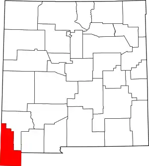 Location within the U.S. state of New Mexico | |
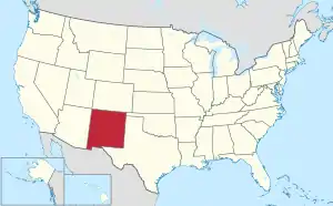 New Mexico's location within the U.S. | |
| Coordinates: 31°55′N 108°43′W | |
| Country | |
| State | |
| Founded | January 1, 1920 |
| Named for | Villa de Guadalupe Hidalgo |
| Seat | Lordsburg |
| Largest city | Lordsburg |
| Area | |
| • Total | 3,446 sq mi (8,930 km2) |
| • Land | 3,437 sq mi (8,900 km2) |
| • Water | 9.1 sq mi (24 km2) 0.3%% |
| Population | |
| • Estimate (2019) | 4,198 |
| • Density | 1.4/sq mi (0.5/km2) |
| Time zone | UTC−7 (Mountain) |
| • Summer (DST) | UTC−6 (MDT) |
| Congressional district | 2nd |
| Website | www |
Geography
According to the U.S. Census Bureau, the county has a total area of 3,446 square miles (8,930 km2), of which 3,437 square miles (8,900 km2) is land and 9.1 square miles (24 km2) (0.3%) is water.[6] The southern part of the county, the part bounded on the east and south by Mexico, is known as the Boot Heel.
Adjacent counties and municipios
- Grant County – north
- Luna County – east
- Cochise County, Arizona – west
- Greenlee County, Arizona – northwest
- Agua Prieta, Sonora, Mexico – southwest
- Ascensión, Chihuahua, Mexico – southeast
- Janos, Chihuahua, Mexico – south
National protected areas
- Coronado National Forest (part)
- Gila National Forest (part)
Demographics
| Historical population | |||
|---|---|---|---|
| Census | Pop. | %± | |
| 1920 | 4,338 | — | |
| 1930 | 5,023 | 15.8% | |
| 1940 | 4,821 | −4.0% | |
| 1950 | 5,095 | 5.7% | |
| 1960 | 4,961 | −2.6% | |
| 1970 | 4,734 | −4.6% | |
| 1980 | 6,049 | 27.8% | |
| 1990 | 5,958 | −1.5% | |
| 2000 | 5,932 | −0.4% | |
| 2010 | 4,894 | −17.5% | |
| 2019 (est.) | 4,198 | [7] | −14.2% |
| U.S. Decennial Census[8] 1790-1960[9] 1900-1990[10] 1990-2000[11] 2010-2016[1] | |||
2000 census
As of the 2000 census,[12] there were 5,932 people in the county, organized into 2,152 households, and 1,542 families. The population density was 1 person per square mile (1/km2). There were 2,848 housing units at an average density of 1 per square mile (0/km2). The racial makeup of the county was 42% White and about 55% of the population was Hispanic.
Size of family households: 592 2-persons, 341 3-persons, 316 4-persons, 165 5-persons, 83 6-persons, 48 7-or-more-persons. The average household size was 2.7 and the average family size was 3.29. In non-family households, there were 684 with 314 male householders (286 living alone), 293 female householders (262 living alone), and 77 non-relatives. In group quarters, there were 85 (all institutionalized).
In the county, the population was spread out, with 31.70% under the age of 18, 7.80% from 18 to 24, 25.20% from 25 to 44, 21.70% from 45 to 64, and 13.60% who were 65 years of age or older. The median age was 35 years. For every 100 females there were 99.60 males. For every 100 females age 18 and over, there were 97.00 males.
The median income for a household in the county was $31,286. The per capita income for the county was $12,431. 27.8% of the population was below the poverty line. Out of the total population, 38.90% of those under the age of 18 and 17.00% of those 65 and older were living below the poverty line. Unemployment rate in April 2010 was 7.6%.
2010 census
As of the 2010 census, there were 4,894 people, 1,936 households, and 1,286 families residing in the county.[13] The population density was 1.4 inhabitants per square mile (0.54/km2). There were 2,393 housing units at an average density of 0.7 per square mile (0.27/km2).[14] The racial makeup of the county was 85.3% white, 0.8% American Indian, 0.6% black or African American, 0.5% Asian, 11.0% from other races, and 1.8% from two or more races. Those of Hispanic or Latino origin made up 56.6% of the population.[13] The largest ancestry groups were: [15]
- 50.3% Mexican
- 15.2% German
- 10.0% English
- 6.0% Irish
- 4.4% Dutch
- 3.6% American
- 2.1% Scottish
- 2.0% Italian
- 1.7% Swedish
- 1.4% Norwegian
- 1.0% Polish
Of the 1,936 households, 33.4% had children under the age of 18 living with them, 46.4% were married couples living together, 14.2% had a female householder with no husband present, 33.6% were non-families, and 29.1% of all households were made up of individuals. The average household size was 2.49 and the average family size was 3.09. The median age was 40.9 years.[13]
The median income for a household in the county was $36,733 and the median income for a family was $41,594. Males had a median income of $43,531 versus $23,482 for females. The per capita income for the county was $17,451. About 20.6% of families and 22.6% of the population were below the poverty line, including 32.3% of those under age 18 and 15.0% of those age 65 or over.[16]
Communities
City
- Lordsburg (county seat)
Village
Census-designated places
Unincorporated communities
- Antelope Wells
- Mouser Place
- Road Forks
- Summit
Ghost towns
- Bramlett
- Cloverdale
- Gary
- Road Fork
- Steins
- Shakespeare
- Valedon
Politics
Hidalgo has historically been a swing county, going for the winner every time since 1928, except for 1968 and 2020, where it went for Hubert Humphrey and Donald Trump respectively.
| Year | Republican | Democratic | Third parties |
|---|---|---|---|
| 2020 | 56.7% 1,117 | 41.7% 821 | 0.7% 31 |
| 2016 | 48.6% 910 | 41.9% 784 | 9.5% 178 |
| 2012 | 46.5% 899 | 51.4% 995 | 2.1% 41 |
| 2008 | 48.0% 936 | 50.9% 993 | 1.1% 22 |
| 2004 | 55.0% 1,081 | 43.8% 861 | 1.1% 22 |
| 2000 | 52.0% 954 | 45.8% 839 | 2.2% 41 |
| 1996 | 40.4% 789 | 48.3% 943 | 11.3% 220 |
| 1992 | 37.6% 871 | 43.0% 995 | 19.4% 449 |
| 1988 | 54.5% 1,100 | 44.6% 901 | 0.9% 19 |
| 1984 | 59.3% 1,282 | 39.8% 860 | 0.9% 19 |
| 1980 | 53.2% 1,059 | 42.2% 840 | 4.6% 92 |
| 1976 | 48.6% 891 | 51.1% 938 | 0.3% 6 |
| 1972 | 63.4% 1,051 | 33.9% 562 | 2.7% 44 |
| 1968 | 39.3% 606 | 43.9% 678 | 16.8% 260 |
| 1964 | 38.4% 628 | 60.9% 995 | 0.7% 11 |
| 1960 | 45.7% 750 | 54.1% 889 | 0.2% 4 |
| 1956 | 50.5% 790 | 49.3% 771 | 0.2% 3 |
| 1952 | 50.6% 781 | 49.0% 757 | 0.4% 6 |
| 1948 | 30.1% 374 | 69.2% 859 | 0.7% 9 |
| 1944 | 31.3% 367 | 68.7% 807 | |
| 1940 | 33.0% 516 | 67.0% 1,049 | |
| 1936 | 22.3% 326 | 76.4% 1,115 | 1.2% 18 |
| 1932 | 20.5% 299 | 77.5% 1,131 | 2.1% 30 |
| 1928 | 52.4% 561 | 47.5% 509 | 0.1% 1 |
| 1924 | 28.2% 261 | 51.4% 476 | 20.4% 189 |
| 1920 | 44.4% 443 | 55.2% 551 | 0.4% 4 |
See also
References
- "State & County QuickFacts". United States Census Bureau. Archived from the original on June 6, 2011. Retrieved September 29, 2013.
- "Find a County". National Association of Counties. Archived from the original on May 31, 2011. Retrieved June 7, 2011.
- "County History". Hidalgo County, NM. Retrieved January 2, 2015.
- "New Mexico: Consolidated Chronology of State and County Boundaries". New Mexico Atlas of Historical County Boundaries. The Newberry Library. 2007. Retrieved January 1, 2015.
- Herrera, Mary (Secretary of State) (2008) New Mexico Blue Book 2007-2008 Office of the Secretary of State, Santa Fe, New Mexico, page 226
- "2010 Census Gazetteer Files". United States Census Bureau. August 22, 2012. Archived from the original on January 1, 2015. Retrieved January 2, 2015.
- "Population and Housing Unit Estimates". Retrieved December 24, 2019.
- "U.S. Decennial Census". United States Census Bureau. Retrieved January 2, 2015.
- "Historical Census Browser". University of Virginia Library. Retrieved January 2, 2015.
- "Population of Counties by Decennial Census: 1900 to 1990". United States Census Bureau. Retrieved January 2, 2015.
- "Census 2000 PHC-T-4. Ranking Tables for Counties: 1990 and 2000" (PDF). United States Census Bureau. Retrieved January 2, 2015.
- "U.S. Census website". United States Census Bureau. Retrieved January 31, 2008.
- "DP-1 Profile of General Population and Housing Characteristics: 2010 Demographic Profile Data". United States Census Bureau. Archived from the original on February 13, 2020. Retrieved January 24, 2016.
- "Population, Housing Units, Area, and Density: 2010 - County". United States Census Bureau. Archived from the original on February 13, 2020. Retrieved January 24, 2016.
- "DP02 SELECTED SOCIAL CHARACTERISTICS IN THE UNITED STATES – 2006-2010 American Community Survey 5-Year Estimates". United States Census Bureau. Archived from the original on February 13, 2020. Retrieved January 24, 2016.
- "DP03 SELECTED ECONOMIC CHARACTERISTICS – 2006-2010 American Community Survey 5-Year Estimates". United States Census Bureau. Archived from the original on February 13, 2020. Retrieved January 24, 2016.
- Leip, David. "Dave Leip's Atlas of U.S. Presidential Elections". uselectionatlas.org. Retrieved April 1, 2018.
External links
- Geology of Lordsburg Quadrangle, Hidalgo County
- Animas, Cotton City, and Playas
- Hidalgo county, New Mexico
- Hidalgo county, New Mexico
Places adjacent to Hidalgo County, New Mexico | |
|---|---|
Municipalities and communities of Hidalgo County, New Mexico, United States | ||
|---|---|---|
| City | Map of New Mexico highlighting Hidalgo County | |
| Village | ||
| CDPs | ||
| Other unincorporated communities | ||
| Ghost towns | ||
| ||
Santa Fe (capital) | ||
| Topics |
| |
| Society | ||
| Regions |
| |
| Cities | ||
| Counties | ||
| Authority control |
|---|