Mamaroneck (village), New York
Mamaroneck /məˈmærənɛk/ mə-MAR-ə-nek is a village in Westchester County, New York, United States. The population was 18,929 at the 2010 census.[3] As of 2019 its population was an estimated 19,131.[4] It is located partially within the town of Mamaroneck and partially within the town of Rye. The portion in Rye is unofficially called "Rye Neck". The Rye Neck Union Free School District contains the Rye Neck portion of Mamaroneck and part of the city of Rye.[5]
Mamaroneck, New York | |
|---|---|
 Seal | |
| Nickname(s): The Friendly Village | |
_highlighted.svg.png.webp) Location of Mamaroneck (village), New York | |
| Coordinates: 40°56′57″N 73°44′1″W | |
| Country | United States |
| State | New York |
| County | Westchester |
| Town | Mamaroneck, Rye (Rye Neck) |
| Area | |
| • Total | 6.62 sq mi (17.13 km2) |
| • Land | 3.21 sq mi (8.31 km2) |
| • Water | 3.41 sq mi (8.82 km2) |
| Elevation | 0 ft (0 m) |
| Population (2010) | |
| • Total | 18,929 |
| • Estimate (2019)[2] | 19,131 |
| • Density | 5,961.67/sq mi (2,301.72/km2) |
| Time zone | UTC-5 (Eastern (EST)) |
| • Summer (DST) | UTC-4 (EDT) |
| ZIP code | 10543 |
| Area code(s) | 914 |
| FIPS code | 36-44831 |
| GNIS feature ID | 0977362 |
History
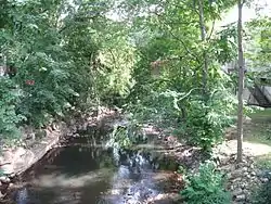
Originally the farming community of Mamaroneck was located on two sides of the Mamaroneck River. In the 1890s the two areas surrounding the river were joined into one commercial village, Mamaroneck, which was incorporated in 1895. The east side of the village lies in the town of Rye and is known as Rye Neck. Some controversy surrounded the incorporation of the village, but the State Appellate Court approved the village's election status. The population of Mamaroneck village in 1895 was 1,500.[6]
Along with the other shore communities of Westchester, Mamaroneck was at one time the location of summer residences for wealthy families from New York City. Summer residence neighborhoods included Greenhaven, Orienta and Shore Acres. The local railroad from New York City (now Metro-North) began to serve the village in 1848. Currently, the village of Mamaroneck is a commuter town for individuals working in Manhattan. A harbor on the Long Island Sound supports facilities for pleasure boating and is the location of Harbor Island Park, a large public park with beach and sporting facilities.
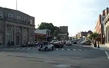
The main commercial streets in Mamaroneck are the Boston Post Road (U.S. Route 1) and Mamaroneck Avenue, the site of several annual parades. Local industry is centered on Fenimore Road.
Other areas of the town include Heathcote Hill overlooking the harbor, Harbor Heights (the heights) to the northeast, Old Rye Neck (settled in the 1880s), Rye Neck (settled in the 1920s and 1930s), Orienta, and Washingtonville, better known as "The Flats", due to the flat, low-lying topography of the area.
Historic sites on National register of Historic Places (NRHP)[7]
Geography
According to the United States Census Bureau, the village has a total area of 6.7 square miles (17 km2), of which 3.2 square miles (8.3 km2) is land and 3.5 square miles (9.1 km2), or 52%, is water.
Demographics
| Historical population | |||
|---|---|---|---|
| Census | Pop. | %± | |
| 1910 | 5,699 | — | |
| 1920 | 6,571 | 15.3% | |
| 1930 | 11,766 | 79.1% | |
| 1940 | 13,034 | 10.8% | |
| 1950 | 15,016 | 15.2% | |
| 1960 | 17,673 | 17.7% | |
| 1970 | 18,909 | 7.0% | |
| 1980 | 17,616 | −6.8% | |
| 1990 | 17,325 | −1.7% | |
| 2000 | 18,752 | 8.2% | |
| 2010 | 18,929 | 0.9% | |
| 2019 (est.) | 19,131 | [2] | 1.1% |
| U.S. Decennial Census[8] | |||
As of the census [9][10] of 2010, there were 18,929 people living in the village. The population density was 5,799.4 inhabitants per square mile (2,239.2/km2). There were 7,353 housing units at an average density of 2,274.1 per square mile (878.0/km2). The racial makeup of the village was 65.3% White, 3.7% Black or African American, 0.1% Native American, 4.8% Asian, 0.03% Pacific Islander, 0.4% from other races, and 1.4% from two or more races. Hispanic or Latino of any race were 24.3% of the population.
There were 6,920 households, out of which 35.4% had children under the age of 18 living with them, 52.3% were married couples living together, 10.9% had a female householder with no husband present, and 33.6% were non-families. 28.1% of all households were made up of individuals, and 11.4% had someone living alone who was 65 years of age or older. The average household size was 2.66 and the average family size was 3.28.
In the village, the population was spread out, with 24% under the age of 18, 6.5% from 18 to 24, 32.0% from 25 to 44, 22.2% from 45 to 64, and 16.1% who were 65 years of age or older. The median age was 40.2 years. For every 100 females, there were 92.0 males. For every 100 females age 18 and over, there were 88.2 males.
The median income for a household in the village was $86,307, and the median income for a family was $97,813. Males had a median income of $65,2563 versus $56,353 for females. The per capita income for the village was $52,750. About 4.2% of families and 6.9% of the population were below the poverty line, including 6.7% of those under age 18 and 9.0% of those age 65 or over.
Education
The Village of Mamaroneck contains portions of two public school districts. As noted above, the northern and eastern parts of the village form part of the Rye Neck Union Free School District; the other part of the Rye Neck Union Free School District lies in the southern portion of the city of Rye. The southern and western parts of the village form part of the Mamaroneck Union Free School District; the remainder of the Mamaroneck Union Free School District covers all of the village of Larchmont, as well as most of the Town of Mamaroneck's unincorporated areas.
Private schools:
Fire Department
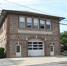
The village of Mamaroneck is protected by 5 all-volunteer fire companies of the Village of Mamaroneck Fire Department (VMFD) that operate out of 4 Fire Stations, located throughout the village. The combined volunteer fire companies operate a total of 5 Engines (including 1 Spare Engine), 2 Trucks, 2 Utility Units, and 3 Command Vehicles. The combined volunteer fire companies respond to approximately 1,000 emergency calls annually.
Fire station locations and apparatus
| Company | Engine | Ladder | Special Unit | Address | Neighborhood |
|---|---|---|---|---|---|
| Mamaro Engine & Hose Co. 1, Mamaroneck Hook & Ladder Co. 1 | Engine 40, Engine 39(Spare) | Tower Ladder 20, Ladder 21 | Utility 90, Marine 2 | 146 Palmer Ave. | Downtown |
| Columbia Hose Co. 2 | Engine 41 | 605 N. Barry Ave. | Barry Avenue | ||
| Volunteers Engine & Hose Co. 3 | Engine 42, Utility 9 | 643 Mamaroneck Ave. | Downtown | ||
| Halstead Manor Hose Co. 4 | Engine 38 | 1400 Halstead Ave. | Halstead Manor |
Mayors
- Tom Murphy, 2017–present
- Norman Rosenblum, 2009–2017
- Kathy Savolt, 2007–2009
- Philip Trifiletti, 2001–2007
- Deborah Chapin, 1999–2001
- Joseph Lanza, 1994–1999
- Paul Noto, 1985–1994
- Robert Funicello 1985
- Suzi Oppenheimer 1977–1985
- Arthur C. Phillips, 1965–1977
- Alexander Schwab, 1957–1964
- Edwin B. Dooley, 1950–1956
- Battista Santoro, ?–1950
Economy
- Archie Comics is headquartered in the village and the town of Mamaroneck.[11][12]
- Marval Industries is a manufacturer of plastics, employing about 70 people.[13] It is one of a very few businesses along Metro-North Railroad's New Haven Line having an active siding for freight usage.
Notable people
- William Kunstler, radical lawyer and civil rights activist; lived on West Street[14]
- Gary Young (drummer), first drummer of the '90s seminal alternative band Pavement
- Cat Greenleaf, News Reporter and Host of NBC's Emmy Award-Winning Program, Talk Stoop
- Matt Dillon grew up in Mamaroneck
- Kevin Dillon grew up in Mamaroneck
- David Spinozza (Studio guitarist, composer, arranger, producer, and conductor) grew up in Mamaroneck
- Norman Rockwell lived in Mamaroneck
- James Fenimore Cooper lived in Mamaroneck
- Scott Leius (baseball player) lived in Mamaroneck
- During the times of silent movies DW Griffith's studio was located on Orienta Point in Mamaroneck and the famous silent movie actresses the Gish sisters both lived there.
- Edwin B. Dooley, former US Congressman
- Robert Ripley had a home on BION (Believe It Or Not) Island, just off Taylor Lane[15]
- Henry Flagler, oil, hotels and railroad baron, circa 1877
- D. W. Griffith, silent film director, lived in Mamaroneck for a few years in the 1920s
Local points of interest
- Most Holy Trinity Church
- Mamaroneck Riot
- Mamaroneck Union Free School District
- Rye Neck Union Free School District
- Mamaroneck High School
- Rye Neck High School
- St. Vito's Church
- Mamaroneck Public Library
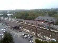
- Mamaroneck (Metro-North station)
- One Room School House
- Cooper/DeLancey House (1811)
- Mile Marker 23
Cemeteries[16]
- DeLancey Burial Ground
- Disbrow Burial Ground
- Eleazor Gedney Burial Ground
- Florence-Powell Burial Ground
- Griffen Rogers Burial Ground
- Guion Burial Ground
- Richbell Cemetery
- Solomon Gedney Burial Ground
- Old Town of Mamaroneck Cemetery
See also
References
- "2019 U.S. Gazetteer Files". United States Census Bureau. Retrieved July 27, 2020.
- "Population and Housing Unit Estimates". United States Census Bureau. May 24, 2020. Retrieved May 27, 2020.
- "Profile of General Population and Housing Characteristics: 2010 Demographic Profile Data (DP-1): Mamaroneck village, New York". United States Census Bureau. Retrieved November 18, 2011.
- "U.S. Census Bureau QuickFacts: Mamaroneck village, New York". www.census.gov. Retrieved 2020-02-01.
- http://www.ryeneck.k12.ny.us/
- "Archived copy". Archived from the original on 2006-09-26. Retrieved 2006-06-20.CS1 maint: archived copy as title (link)
- "National Register Information System". National Register of Historic Places. National Park Service. July 9, 2010.
- "Census of Population and Housing". Census.gov. Retrieved June 4, 2015.
- http://censusviewer.com/city/NY/Mamaroneck
- http://www.zip-codes.com/city/ny-mamaroneck-2010-census.asp
- "Mamaroneck town, Westchester county, New York." U.S. Census Bureau. Retrieved on August 29, 2009.
- "Management Archived 2009-08-20 at the Wayback Machine." Archie Comics. Retrieved on August 29, 2009.
- "Marval Industries (Marval Industries Inc) - Mamaroneck, New York (NY) – Company Profile". Manta Media Inc. Retrieved August 3, 2011.
- Langum, David J. (1999). William M. Kunstler: the most hated lawyer in America. Chapter 6 - Circus in Chicago: NYU Press. ISBN 0-8147-5150-4.
Kunstler threw the first reunion at his Mamaroneck home...
CS1 maint: location (link) - http://www.westchesterhistory.com/index.php/exhibits/people?display=ripley
- https://archives.westchestergov.com/images/stories/contentdm/WestchesterCountyCemeteryIndex.pdf
External links
Municipalities and communities of Westchester County, New York, United States | ||
|---|---|---|
| Cities | 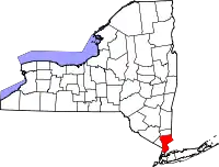 | |
| Towns | ||
| Villages | ||
| CDPs |
| |
| Other hamlets | ||
| Footnotes | ‡This populated place also has portions in an adjacent county or counties | |
| ||