National Register of Historic Places listings in Beauregard Parish, Louisiana
This is a list of the National Register of Historic Places listings in Beauregard Parish, Louisiana.
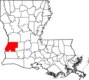
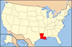
Location of Beauregard Parish in Louisiana
This is intended to be a complete list of the properties on the National Register of Historic Places in Beauregard Parish, Louisiana, United States. The locations of National Register properties for which the latitude and longitude coordinates are included below, may be seen in a map.[1]
There are 13 properties listed on the National Register in the parish.
- This National Park Service list is complete through NPS recent listings posted January 29, 2021.[2]
Current listings
| [3] | Name on the Register | Image | Date listed[4] | Location | City or town | Description |
|---|---|---|---|---|---|---|
| 1 | Beauregard Parish Courthouse | 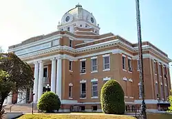 Beauregard Parish Courthouse |
September 22, 1983 (#83000490) |
201 West 1st Street 30°50′46″N 93°17′16″W |
DeRidder | |
| 2 | Beauregard Parish Jail | 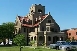 Beauregard Parish Jail |
December 17, 1981 (#81000711) |
205 West 1st Street 30°50′47″N 93°17′18″W |
DeRidder | |
| 3 | Beauregard Parish Training School | Beauregard Parish Training School |
March 1, 1996 (#96000190) |
Corner of Martin Luther King Drive and Alexander Street 30°50′33″N 93°16′20″W |
DeRidder | |
| 4 | Burks House | .jpg.webp) Burks House |
September 8, 1987 (#87001512) |
637 North Railroad Avenue 30°45′15″N 93°32′30″W |
Merryville | |
| 5 | DeRidder Commercial Historic District | .jpg.webp) DeRidder Commercial Historic District |
August 9, 1983 (#83000491) |
Roughly bounded by Washington Street, West 2nd Street, Stewart Street, and West Port Street 30°50′51″N 93°17′12″W |
DeRidder | |
| 6 | DeRidder USO Building | DeRidder USO Building |
February 25, 1992 (#92000037) |
250 West 7th Street 30°50′26″N 93°17′19″W |
DeRidder | |
| 7 | Dry Creek High School Building | January 28, 1988 (#87002572) |
East side of Louisiana Highway 113, about 300 yards (270 m) south of junction with Louisiana Highway 394 30°40′10″N 93°02′42″W |
Dry Creek | ||
| 8 | First Street School | November 19, 1998 (#98001380) |
401 West 1st Street 30°50′47″N 93°17′23″W |
DeRidder | ||
| 9 | First United Methodist Church | .jpg.webp) First United Methodist Church |
November 21, 1991 (#91001659) |
Southwest corner of North Pine Street and West Port Street 30°50′55″N 93°17′21″W |
DeRidder | |
| 10 | Hudson River Lumber Company General Manager's House | .jpg.webp) Hudson River Lumber Company General Manager's House |
February 21, 2007 (#07000068) |
411 South Washington Street 30°50′34″N 93°17′13″W |
DeRidder | |
| 11 | Shady Grove School and Community Building | 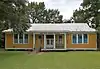 Shady Grove School and Community Building |
December 20, 2002 (#02001545) |
2400 Louisiana Highway 26 30°48′14″N 93°10′30″W |
DeRidder | |
| 12 | Sills House | February 21, 2007 (#07000067) |
211 West 4th Street 30°50′39″N 93°17′19″W |
DeRidder | ||
| 13 | Toy House | .jpg.webp) Toy House |
February 21, 2007 (#07000066) |
205 West 4th Street 30°50′38″N 93°17′17″W |
DeRidder |
See also
| Wikimedia Commons has media related to National Register of Historic Places in Beauregard Parish, Louisiana. |
References
- The latitude and longitude information provided in this table was derived originally from the National Register Information System, which has been found to be fairly accurate for about 99% of listings. Some locations in this table may have been corrected to current GPS standards.
- "National Register of Historic Places: Weekly List Actions". National Park Service, United States Department of the Interior. Retrieved on January 29, 2021.
- Numbers represent an alphabetical ordering by significant words. Various colorings, defined here, differentiate National Historic Landmarks and historic districts from other NRHP buildings, structures, sites or objects.
- The eight-digit number below each date is the number assigned to each location in the National Register Information System database, which can be viewed by clicking the number.
Municipalities and communities of Beauregard Parish, Louisiana, United States | ||
|---|---|---|
| City | | |
| Town | ||
| CDPs | ||
| Other unincorporated communities | ||
| Ghost town | ||
| Footnotes | ‡This populated place also has portions in an adjacent parish or parishes | |
| ||
This article is issued from Wikipedia. The text is licensed under Creative Commons - Attribution - Sharealike. Additional terms may apply for the media files.