National Register of Historic Places listings in Bossier Parish, Louisiana
This is a list of the National Register of Historic Places listings in Bossier Parish, Louisiana.
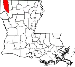
Location of Bossier Parish in Louisiana
This is intended to be a complete list of the properties on the National Register of Historic Places in Bossier Parish, Louisiana, United States. The locations of National Register properties for which the latitude and longitude coordinates are included below, may be seen in a map.[1]
There are 6 properties listed on the National Register in the parish.
- This National Park Service list is complete through NPS recent listings posted January 29, 2021.[2]
Current listings
| [3] | Name on the Register | Image | Date listed[4] | Location | City or town | Description |
|---|---|---|---|---|---|---|
| 1 | Barksdale Field Historic District | 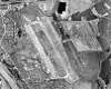 Barksdale Field Historic District |
April 13, 1992 (#92000332) |
Junction of U.S. Route 71 and West Gate Drive 32°30′11″N 93°40′48″W |
Bossier City | |
| 2 | Bossier City Municipal Building | March 28, 2002 (#02000267) |
630 Barksdale Boulevard 32°30′56″N 93°43′57″W |
Bossier City | ||
| 3 | Bossier High School | August 31, 1998 (#98001079) |
1000 Traffic Street 32°31′20″N 93°44′11″W |
Bossier City | ||
| 4 | Bossier High School | Bossier High School |
September 30, 2004 (#04001078) |
777 Bearkat Drive 32°31′09″N 93°43′47″W |
Bossier City | |
| 5 | Cashpoint Plantation House | August 11, 1982 (#82002757) |
North of Louisiana Highway 71 about 0.92 miles (1.48 km) southeast of Taylortown and 2.43 miles (3.91 km) northwest of Elm Grove 32°22′42″N 93°35′01″W |
Elm Grove | ||
| 6 | Hughes House | 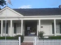 Hughes House |
October 22, 1996 (#96001163) |
414 Sibley Street 32°41′39″N 93°44′23″W |
Benton | Enlisted in 1976 at original location on LA 160, 13 miles (21 km) northeast of Benton with NRHP reference #76000962. Delisted for move in September 1996 and relisted with new reference number (#96001163) in October 1996. |
See also
| Wikimedia Commons has media related to National Register of Historic Places in Bossier Parish, Louisiana. |
References
- The latitude and longitude information provided in this table was derived originally from the National Register Information System, which has been found to be fairly accurate for about 99% of listings. Some locations in this table may have been corrected to current GPS standards.
- "National Register of Historic Places: Weekly List Actions". National Park Service, United States Department of the Interior. Retrieved on January 29, 2021.
- Numbers represent an alphabetical ordering by significant words. Various colorings, defined here, differentiate National Historic Landmarks and historic districts from other NRHP buildings, structures, sites or objects.
- The eight-digit number below each date is the number assigned to each location in the National Register Information System database, which can be viewed by clicking the number.
Municipalities and communities of Bossier Parish, Louisiana, United States | ||
|---|---|---|
| Cities | | |
| Towns | ||
| CDPs | ||
| Other unincorporated communities |
| |
| Footnotes | ‡This populated place also has portions in an adjacent parish or parishes | |
| ||
This article is issued from Wikipedia. The text is licensed under Creative Commons - Attribution - Sharealike. Additional terms may apply for the media files.