National Register of Historic Places listings in Iberville Parish, Louisiana
This is a list of the National Register of Historic Places listings in Iberville Parish, Louisiana.
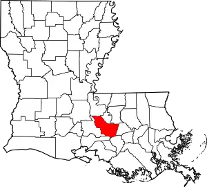
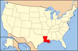
Location of Iberville Parish in Louisiana
This is intended to be a complete list of the properties and districts on the National Register of Historic Places in Iberville Parish, Louisiana, United States. The locations of National Register properties and districts for which the latitude and longitude coordinates are included below, may be seen in a map.[1]
There are 23 properties and districts listed on the National Register in the parish.
- This National Park Service list is complete through NPS recent listings posted February 5, 2021.[2]
Current listings
| [3] | Name on the Register[4] | Image | Date listed[5] | Location | City or town | Description |
|---|---|---|---|---|---|---|
| 1 | Bagatelle Plantation House | %252C_Donaldsonville_vicinity_(St._James_Parish%252C_Louisiana).jpg.webp) Bagatelle Plantation House |
May 9, 2007 (#07000424) |
695 River Road (LA 991) 30°18′34″N 91°11′08″W |
Sunshine | |
| 2 | Bayou Paul Colored School | 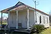 Bayou Paul Colored School |
January 26, 2016 (#15001000) |
915 Bayou Paul Road 30°18′12″N 91°06′46″W |
St. Gabriel | Building was moved in Amanda Grace Memorial Park in 2006 and is currently used as the Bayou Paul Colored School
Museum.[6] |
| 3 | Bayou Plaquemine Lock | 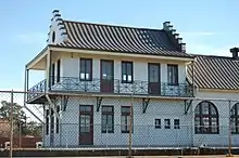 Bayou Plaquemine Lock |
May 19, 1972 (#72000554) |
U.S. Government Reservation at the confluence of Bayou Plaquemine and the Mississippi River 30°17′33″N 91°14′05″W |
Plaquemine | Lock building is also part of Plaquemine Historic District since its creation on October 30, 1989.[7] |
| 4 | Carville Historic District | 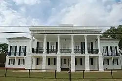 Carville Historic District |
November 18, 1992 (#92001529) |
5445 Point Clair Road 30°11′52″N 91°07′37″W |
Carville | Federal and formerly state hospital addressing leprosy built mostly during 1939-1941, important in the history of medicine. Also includes Indian Camp Plantation House (1859) designed by Henry Howard. |
| 5 | Church of the Nativity | 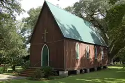 Church of the Nativity |
August 11, 1982 (#82002775) |
15615 Laurel Street 30°26′42″N 91°27′08″W |
Rosedale | |
| 6 | Desobry Building | 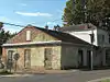 Desobry Building |
November 6, 1986 (#86003128) |
58415 Court Street 30°17′04″N 91°14′35″W |
Plaquemine | |
| 7 | Andrew H. Gay House |  Andrew H. Gay House |
July 18, 1985 (#85001582) |
1010 McDuffie Street 30°18′09″N 91°14′25″W |
Plaquemine | |
| 8 | Homestead Plantation Complex | 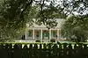 Homestead Plantation Complex |
November 6, 1986 (#86003129) |
Along Bayou Road (LA 3066), about 2.9 miles (4.7 km) southwest of Plaquemine 30°15′31″N 91°16′01″W |
Plaquemine | Also known as Variety Plantation. |
| 9 | Iberville Parish Courthouse | 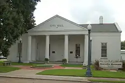 Iberville Parish Courthouse |
May 31, 1980 (#80001732) |
57735 Main Street 30°17′30″N 91°14′02″W |
Plaquemine | Greek Revival 1848 former parish courthouse serves today as the Iberville Museum. Also part of Plaquemine Historic District since its creation on October 30, 1989.[7] |
| 10 | Live Oaks Plantation | 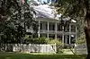 Live Oaks Plantation |
November 20, 1974 (#74000924) |
Along LA 77, about 435 yards (398 m) northwest of intersection with LA 76 30°26′36″N 91°27′23″W |
Rosedale | |
| 11 | Lucky Plantation House | 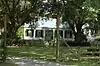 Lucky Plantation House |
December 27, 2002 (#02001603) |
1295 River Road (LA 75) 30°17′12″N 91°11′52″W |
Sunshine | |
| 12 | Nottoway Plantation House | 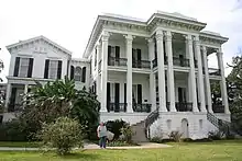 Nottoway Plantation House |
June 6, 1980 (#80001733) |
31025 LA 1 30°11′11″N 91°10′01″W |
White Castle | |
| 13 | Plaquemine High School | 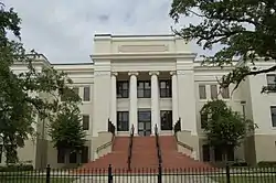 Plaquemine High School |
February 13, 1992 (#92000041) |
58060 Plaquemine Street 30°17′20″N 91°14′16″W |
Plaquemine | |
| 14 | Plaquemine Historic District |  Plaquemine Historic District |
October 30, 1989 (#89001791) |
Railroad Avenue, Main Street, Eden Street, Church Street, Plaquemine Street and Court Street 30°17′24″N 91°14′11″W |
Plaquemine | Boundaries were increased on June 3, 2005. |
| 15 | Pierre Ernest Rivet House | 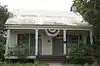 Pierre Ernest Rivet House |
November 17, 2001 (#01001235) |
58159 Plaquemine Street 30°17′16″N 91°14′20″W |
Plaquemine | |
| 16 | St. Basil's Academy | 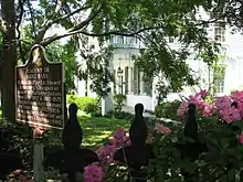 St. Basil's Academy |
October 5, 1982 (#82000439) |
23515 Church Street 30°17′25″N 91°14′00″W |
Plaquemine | Also part of Plaquemine Historic District since its creation on October 30, 1989.[7] |
| 17 | St. Gabriel Roman Catholic Church | 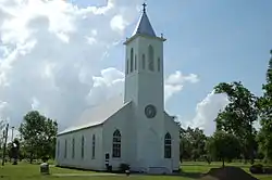 St. Gabriel Roman Catholic Church |
November 27, 1972 (#72000555) |
3625 LA 75 30°15′16″N 91°06′07″W |
St. Gabriel | |
| 18 | St. John Baptist Church |  St. John Baptist Church |
January 21, 1994 (#93001549) |
31925 Lacroix Road 30°10′38″N 91°09′38″W |
White Castle | |
| 19 | St. Louis Plantation |  St. Louis Plantation |
December 3, 1975 (#75000849) |
Along St. Louis Road, about 325 yards (297 m) southwest of River Road (LA 405) 30°16′25″N 91°12′44″W |
Plaquemine | Antebellum home of Italianate and Greek Revival style, located on a working sugar cane plantation. |
| 20 | Schexnayder House | January 19, 1989 (#88003224) |
610 Pecan Drive 30°18′43″N 91°05′56″W |
St. Gabriel | ||
| 21 | J. Supple's Sons Mercantile Company, Ltd. | 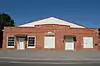 J. Supple's Sons Mercantile Company, Ltd. |
May 10, 2005 (#05000406) |
29801-29899 River Road (LA 405) 30°12′29″N 91°10′12″W |
Bayou Goula | |
| 22 | Tally-Ho Plantation House | 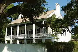 Tally-Ho Plantation House |
January 20, 1980 (#80001731) |
Along River Road (LA 405) 30°12′11″N 91°10′14″W |
Bayou Goula | |
| 23 | Trinity | 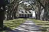 Trinity |
January 7, 1994 (#93001493) |
Along LA 77, about 0.3 miles (0.48 km) southeast of its junction with LA 76 30°26′13″N 91°27′05″W |
Rosedale |
See also
| Wikimedia Commons has media related to National Register of Historic Places in Iberville Parish, Louisiana. |
References
- The latitude and longitude information provided in this table was derived originally from the National Register Information System, which has been found to be fairly accurate for about 99% of listings. Some locations in this table may have been corrected to current GPS standards.
- "National Register of Historic Places: Weekly List Actions". National Park Service, United States Department of the Interior. Retrieved on February 5, 2021.
- Numbers represent an alphabetical ordering by significant words. Various colorings, defined here, differentiate National Historic Landmarks and historic districts from other NRHP buildings, structures, sites or objects.
- "National Register Information System". National Register of Historic Places. National Park Service. March 13, 2009.
- The eight-digit number below each date is the number assigned to each location in the National Register Information System database, which can be viewed by clicking the number.
- "Bayou Paul Colored School" (PDF). State of Louisiana's Division of Historic Preservation. Retrieved June 19, 2018. with 12 photo and two maps
- "Plaquemine Historic District" (PDF). State of Louisiana's Division of Historic Preservation. Retrieved June 20, 2018.
Municipalities and communities of Iberville Parish, Louisiana, United States | ||
|---|---|---|
| Cities | | |
| Towns | ||
| Villages | ||
| CDPs | ||
| Other unincorporated communities | ||
| Ghost towns | ||
| ||
This article is issued from Wikipedia. The text is licensed under Creative Commons - Attribution - Sharealike. Additional terms may apply for the media files.