National Register of Historic Places listings in Caddo Parish, Louisiana
This is a list of the National Register of Historic Places listings in Caddo Parish, Louisiana.
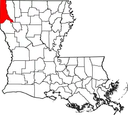
Location of Caddo Parish in Louisiana
This is intended to be a complete list of the properties and districts on the National Register of Historic Places in Caddo Parish, Louisiana, United States. The locations of National Register properties and districts for which the latitude and longitude coordinates are included below, may be seen in a map.[1]
There are 69 properties and districts listed on the National Register in the parish, including 2 National Historic Landmarks. Three properties were once listed, but have since been removed.
- This National Park Service list is complete through NPS recent listings posted February 5, 2021.[2]
Current listings
| [3] | Name on the Register[4] | Image | Date listed[5] | Location | City or town | Description |
|---|---|---|---|---|---|---|
| 1 | Antioch Baptist Church | 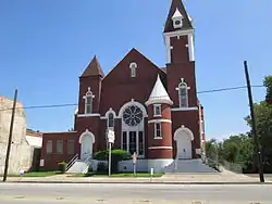 Antioch Baptist Church |
November 1, 1982 (#82000431) |
1057 Texas Avenue 32°30′14″N 93°45′13″W |
Shreveport | Also contributing property of St. Paul's Bottoms historic district since its boundary increase on July 9, 1999.[6] |
| 2 | C.C. Antoine House | .jpg.webp) C.C. Antoine House |
August 20, 1999 (#99001013) |
1941 Perrin Street 32°30′35″N 93°46′15″W |
Shreveport | In April 2007 a move of the property to a public park at corner of Sycamore Avenue and Milam Street was pre-approved, but never took place.[7] |
| 3 | B'Nai Zion Temple | .jpg.webp) B'Nai Zion Temple |
January 21, 1994 (#93001547) |
802 Cotton Street 32°30′30″N 93°45′02″W |
Shreveport | Also contributing property of Shreveport Commercial Historic District since its first boundary increase on May 16, 1997.[8] |
| 4 | Bethune Junior-Senior High School | February 21, 2018 (#100002113) |
4331 Henry Street 32°27′50″N 93°48′44″W |
Shreveport | Part of Caddo Parish Public School System Building Program, 1946-1961 MPS.[9] | |
| 5 | C. E. Byrd High School | 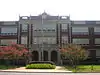 C. E. Byrd High School |
June 10, 1991 (#91000704) |
3201 Line Avenue 32°28′49″N 93°44′43″W |
Shreveport | |
| 6 | Caddo Lake Bridge | .jpg.webp) Caddo Lake Bridge |
October 18, 1996 (#96001166) |
Across Caddo Lake, next modern LA 538 bridge 32°41′47″N 93°57′28″W |
Mooringsport | |
| 7 | Caddo Parish Confederate Monument | .jpg.webp) Caddo Parish Confederate Monument |
January 29, 2014 (#13001124) |
501 Texas Street 32°30′44″N 93°45′00″W |
Shreveport | |
| 8 | Caspiana House | 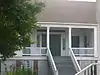 Caspiana House |
December 10, 1981 (#81000288) |
Pioneer Heritage Center, Louisiana State University campus 32°25′52″N 93°42′11″W |
Shreveport | |
| 9 | Central Fire Station | .jpg.webp) Central Fire Station |
May 28, 1991 (#91000625) |
801 Crockett Street 32°30′32″N 93°45′03″W |
Shreveport | Now hosting the Shreveport Regional Arts Council. Also contributing property of Shreveport Commercial Historic District since its first boundary increase on May 16, 1997.[8] |
| 10 | Central High School | 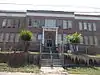 Central High School |
May 16, 1991 (#91000606) |
1627 Weinstock Street 32°30′02″N 93°45′51″W |
Shreveport | Also known as Central Elementary School |
| 11 | Central Railroad Station | 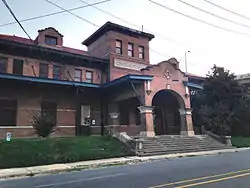 Central Railroad Station |
May 28, 1991 (#91000622) |
1025 Marshall Street 32°30′32″N 93°44′43″W |
Shreveport | Also contributing property of Shreveport Commercial Historic District since its second boundary increase on April 29, 2015.[8] |
| 12 | Crystal Grocery | .jpg.webp) Crystal Grocery |
March 5, 1998 (#98000181) |
1124 Fairfield Avenue 32°30′12″N 93°45′02″W |
Shreveport | Also known as Fertitta's Delicatessen. |
| 13 | Davidson House | .jpg.webp) Davidson House |
December 22, 1983 (#83003604) |
654 Wichita Street 32°29′41″N 93°44′37″W |
Shreveport | Also contributing property of Highland Historic District.[10] |
| 14 | Dodd College President's Home | 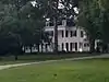 Dodd College President's Home |
July 22, 1982 (#82002758) |
601 Ockley Drive 32°28′07″N 93°44′32″W |
Shreveport | |
| 15 | Dunn House | 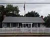 Dunn House |
December 2, 1998 (#98001423) |
9371 Greenwood Road 32°26′36″N 93°58′29″W |
Greenwood | |
| 16 | Fair Park High School | 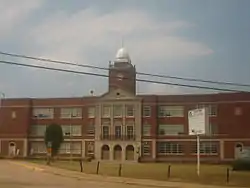 Fair Park High School |
January 11, 2001 (#00001630) |
3222 Greenwood Road 32°28′45″N 93°47′26″W |
Shreveport | |
| 17 | The Fairfield Building | September 17, 2013 (#13000729) |
1600-1612 Fairfield Avenue 32°29′49″N 93°45′10″W |
Shreveport | ||
| 18 | Fairfield Historic District | 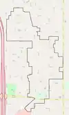 Fairfield Historic District |
February 19, 1987 (#87000190) |
Fairfield Avenue and adjacent streets, from Olive Street to Kings Highway 32°29′12″N 93°44′59″W |
Shreveport | The 120.6 acres (48.8 ha) historic district comprises 253 contributing properties built between 1900 and 1936. On October 24, 1996, an additional property located at 948 Boulevard Street increased district boundaries.[11] |
| 19 | First Presbyterian Church | .jpg.webp) First Presbyterian Church |
June 15, 2011 (#11000358) |
900 Jordan Street 32°29′55″N 93°44′56″W |
Shreveport | |
| 20 | Flesch House |  Flesch House |
June 10, 1991 (#91000703) |
415 Sherwood Road 32°27′09″N 93°44′18″W |
Shreveport | |
| 21 | Flournoy-Wise House |  Flournoy-Wise House |
March 16, 1990 (#90000435) |
9251 Bois d'Arc Lane 32°26′30″N 93°58′38″W |
Greenwood | Originally at 9152 Bois d'Arc Lane. |
| 22 | Forest Home | October 30, 1989 (#89001873) |
About 240 yards (220 m) west of Johns Road and Johns Gin Road intersection 32°12′29″N 94°01′31″W |
Four Forks | ||
| 23 | Highland Historic District |  Highland Historic District |
February 19, 1987 (#87000192) |
Roughly bounded by Vine Street, Gilbert Drive, and Topeka Street and Irving Place; also roughly bounded by Stoner Avenue, Centenary Boulevard, Kings Highway, and Line Avenue 32°29′30″N 93°44′23″W |
Shreveport | The 96.8 acres (39.2 ha) historic district comprises 251 contributing properties built between c.1890 and 1933. Second set of boundaries represents an increase of April 17, 2001.[12] |
| 24 | Holy Trinity Catholic Church | 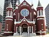 Holy Trinity Catholic Church |
September 27, 1984 (#84001261) |
315 Marshall Street 32°30′52″N 93°45′03″W |
Shreveport | Also contributing property of Shreveport Commercial Historic District since its second boundary increase on April 29, 2015.[8] |
| 25 | Walter B. Jacobs House | September 19, 2016 (#16000670) |
5935 East Ridge Drive 32°27′09″N 93°44′04″W |
Shreveport | ||
| 26 | Jefferson Hotel | July 27, 1989 (#89000977) |
907 Louisiana Avenue 32°30′30″N 93°44′52″W |
Shreveport | Also contributing property of Shreveport Commercial Historic District since its first boundary increase on May 16, 1997.[8] | |
| 27 | Kansas City Southern Depot | 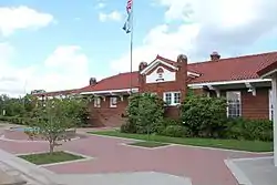 Kansas City Southern Depot |
January 20, 1995 (#94001578) |
100 North West Front Street 32°52′19″N 93°59′07″W |
Vivian | |
| 28 | Kansas City Southern Railroad Bridge, Cross Bayou | 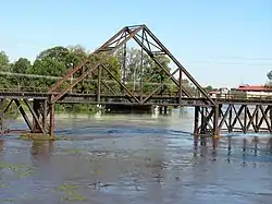 Kansas City Southern Railroad Bridge, Cross Bayou |
March 23, 1995 (#95000347) |
Over Cross Bayou, between North Spring Street bridge and Clyde Fant Memorial Parkway bridge 32°31′10″N 93°45′00″W |
Shreveport | |
| 29 | Kings Highway Christian Church | 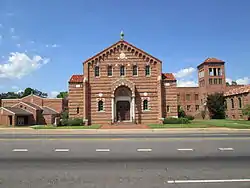 Kings Highway Christian Church |
August 7, 1989 (#89001042) |
806 Kings Highway 32°28′54″N 93°44′48″W |
Shreveport | |
| 30 | Lakeside Municipal Golf Course | 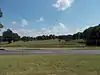 Lakeside Municipal Golf Course |
June 1, 2005 (#05000504) |
2200 Milam Street 32°30′19″N 93°46′40″W |
Shreveport | The historic golf course comprises a 38 acres (15 ha) area at northeast corner of Hearne Avenue and Milam Street. |
| 31 | Lewis House | .jpg.webp) Lewis House |
July 27, 1979 (#79001054) |
675 Jordan Street 32°29′53″N 93°44′40″W |
Shreveport | Also contributing property of Highland Historic District.[10] |
| 32 | Col. Robert H. Lindsay House | July 16, 1973 (#73000861) |
2803 Woodlawn Avenue 32°29′04″N 93°43′45″W |
Shreveport | Also known as Symphony House and Scofield House. | |
| 33 | Line Avenue School | .jpg.webp) Line Avenue School |
June 3, 1981 (#81000289) |
1800 Line Avenue 32°29′39″N 93°44′47″W |
Shreveport | Building now host Northwestern State University nursing campus. |
| 34 | Huey P. Long House | 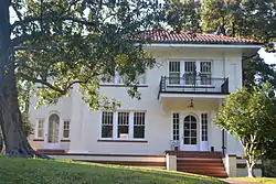 Huey P. Long House |
August 15, 1991 (#91001060) |
305 Forest Avenue 32°28′47″N 93°44′11″W |
Shreveport | |
| 35 | Louisiana State Exhibit Building | 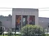 Louisiana State Exhibit Building |
February 20, 1991 (#91000071) |
3015 Greenwood Road 32°28′48″N 93°47′06″W |
Shreveport | |
| 36 | Mason House | May 22, 2001 (#01000512) |
103 Ardmore Avenue 32°28′38″N 93°43′06″W |
Shreveport | ||
| 37 | Masonic Temple | .jpg.webp) Masonic Temple |
June 10, 1991 (#91000702) |
1805 Creswell Avenue 32°29′39″N 93°44′29″W |
Shreveport | Also contributing property of Highland Historic District.[10] |
| 38 | Mooringsport School | .jpg.webp) Mooringsport School |
June 13, 1996 (#96000605) |
602 Latimer Street 32°41′14″N 93°57′37″W |
Mooringsport | Also known as Mooringsport Elementary School. |
| 39 | Oakland Cemetery | .jpg.webp) Oakland Cemetery |
July 13, 1977 (#77000667) |
Bounded by Milam Street, Christian Street and Sprague Street 32°30′31″N 93°45′17″W |
Shreveport | |
| 40 | Ogilvie Hardware Company Building | October 12, 2000 (#00001210) |
217 Jones Street 32°30′33″N 93°44′32″W |
Shreveport | Converted to 90 loft-style apartments in 2011, while preserving the historic building.[13] | |
| 41 | Oil City School | .jpg.webp) Oil City School |
August 2, 2017 (#100001429) |
407 North Kerley Avenue 32°44′54″N 93°58′15″W |
Oil City | Also known as Oil City Elementary Middle Magnet School, the 6 acres (2.4 ha) area comprises three historic buildings (Elementary School, High School and Gym/Cafeteria) and one historic site (Football/Baseball Field).[14] |
| 42 | Old Commercial National Bank Building | .jpg.webp) Old Commercial National Bank Building |
March 11, 1982 (#82002759) |
509 Market Street 32°30′51″N 93°44′51″W |
Shreveport | Also known as the United Mercantile Bank Building. Built in 1910. Not to be confused with nearby 1938-39 building at the corner of Edward Street and Texas Street. Also contributing property of Shreveport Commercial Historic District since its creation on March 11, 1982.[8] |
| 43 | Petroleum Tower | .jpg.webp) Petroleum Tower |
September 17, 2013 (#13000730) |
425 Edwards Street 32°30′50″N 93°44′56″W |
Shreveport | Also contributing property of Shreveport Commercial Historic District since its creation on March 11, 1982.[8] |
| 44 | St. Mark's Episcopal Church | .jpg.webp) St. Mark's Episcopal Church |
June 11, 1991 (#91000700) |
875 Cotton Street 32°30′25″N 93°45′05″W |
Shreveport | Now known as Church of the Holy Cross. Also contributing property of Shreveport Commercial Historic District since its first boundary increase on May 16, 1997.[8] |
| 45 | St. Paul's Bottoms | 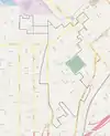 St. Paul's Bottoms |
October 11, 1984 (#84000033) |
Roughly bounded by North Western Avenue, North Pierre Avenue, Alston Street, Christian Street, Oakland Street, Snow Street, Texas Avenue and Milam Street 32°30′26″N 93°45′28″W |
Shreveport | Also known as Ledbetter Heights. The 134 acres (54 ha) area comprises a total of 792 contributing properties built between c.1880 and c.1934. A boundary increase, including 17 other contributing properties located on Texas Avenue and Milam Street, took place on July 9, 1999.[15] |
| 46 | Scottish Rite Cathedral | .jpg.webp) Scottish Rite Cathedral |
November 6, 1986 (#86003132) |
725 Cotton Street 32°30′30″N 93°44′59″W |
Shreveport | Also contributing property of Shreveport Commercial Historic District since its first boundary increase on May 16, 1997.[8] |
| 47 | Shreveport Commercial Historic District |  Shreveport Commercial Historic District |
March 11, 1982 (#82002760) |
Roughly bounded by Commerce Street, Crockett Street, Market Street, Franklin Street, Lake Street, Commons Street, Elvis Presley Avenue, Douglas Street, Travis Street, Marshall Street and Fannin Street 32°30′43″N 93°44′59″W |
Shreveport | Also known as Downtown Shreveport Historic District. The 145 acres (59 ha) area comprises a total of 181 contributing properties. A first boundary increase took place on May 16, 1997, and a subsequent modification was made on April 29, 2015.[16][17] |
| 48 | Shreveport Fire Station No. 8 | 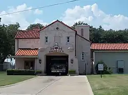 Shreveport Fire Station No. 8 |
June 30, 2000 (#00000683) |
3406 Velva Avenue 32°28′49″N 93°46′54″W |
Shreveport | |
| 49 | Shreveport Municipal Building |  Shreveport Municipal Building |
May 5, 1982 (#82002761) |
724 McNeil Street 32°30′35″N 93°44′55″W |
Shreveport | Also contributing property of Shreveport Commercial Historic District since its first boundary increase on May 16, 1997.[8] |
| 50 | Shreveport Municipal Memorial Auditorium | 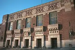 Shreveport Municipal Memorial Auditorium |
May 28, 1991 (#91000624) |
705 Elvis Presley Boulevard 32°30′29″N 93°45′11″W |
Shreveport | Also contributing property of Shreveport Commercial Historic District since its first boundary increase on May 16, 1997.[8] |
| 51 | Shreveport Water Works Company, Pump Station | .jpg.webp) Shreveport Water Works Company, Pump Station |
May 9, 1980 (#80001707) |
142 North Common Street 32°31′04″N 93°45′26″W |
Shreveport | |
| 52 | Shreveport Woman's Department Club Building | .jpg.webp) Shreveport Woman's Department Club Building |
July 18, 1985 (#85001590) |
802 Margaret Place 32°29′47″N 93°44′47″W |
Shreveport | |
| 53 | South Highlands Fire Station |  South Highlands Fire Station |
May 28, 1991 (#91000626) |
763 Oneonta Street 32°27′53″N 93°44′45″W |
Shreveport | Also a contributing property to South Highlands Historic District |
| 54 | South Highlands Historic District | 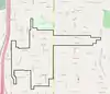 South Highlands Historic District |
April 29, 1999 (#99000496) |
Roughly bounded by Southern Avenue, Lawhon Street, Fairfield Avenue, Trabue Street, Unadilla Street, Gilbert Drive, Oneonta Street, Line Avenue, Thora Boulevard, Thornhill Avenue, Delmar Street and Southfield Road 32°27′50″N 93°44′54″W |
Shreveport | The 188 acres (76 ha) area comprises a total of 394 contributing properties built between 1912 and 1949.[18][19] |
| 55 | Star Cemetery | 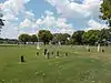 Star Cemetery |
January 17, 2002 (#01001478) |
West of St. Joseph Cemetery, access entrance in front of 2205 Texas Avenue 32°29′26″N 93°46′09″W |
Shreveport | |
| 56 | A. C. Steere Elementary School | February 20, 1991 (#91000074) |
4009 Youree Drive 32°28′01″N 93°43′18″W |
Shreveport | ||
| 57 | Strand Theatre | .jpg.webp) Strand Theatre |
May 26, 1977 (#77000668) |
630 Crockett Street 32°30′37″N 93°45′00″W |
Shreveport | Also contributing property of Shreveport Commercial Historic District since its first boundary increase on May 16, 1997.[8] |
| 58 | Tally's Bank | July 14, 1976 (#76000963) |
525 Spring Street 32°30′52″N 93°44′46″W |
Shreveport | Also contributing property of Shreveport Commercial Historic District since its creation on March 11, 1982.[8] | |
| 59 | Taylor Wholesale Grocers and Cotton Factors Warehouse-Lee Hardware Building | February 13, 1986 (#86000251) |
719-729 Edwards Street 32°30′42″N 93°44′47″W |
Shreveport | Now known as Lee Hardware, building is also a contributing property of Shreveport Commercial Historic District since its first boundary increase on May 16, 1997.[8] | |
| 60 | Texas Avenue Buildings | .jpg.webp) Texas Avenue Buildings |
May 25, 1979 (#79001055) |
824-874 Texas Avenue 32°30′31″N 93°45′07″W |
Shreveport | All the district buildings became contributing properties of Shreveport Commercial Historic District since its first boundary increase on May 16, 1997.[8] |
| 61 | Thrasher House | September 10, 1987 (#87001565) |
Pioneer Heritage Center, Louisiana State University campus 32°25′53″N 93°42′12″W |
Shreveport | ||
| 62 | Trees City Office and Bank Building | 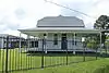 Trees City Office and Bank Building |
August 13, 1986 (#86001492) |
200 South Land Avenue 32°44′28″N 93°58′16″W |
Oil City | |
| 63 | Trosper House | 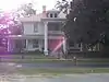 Trosper House |
May 14, 1987 (#87000728) |
7078 Magnolia Street 32°26′29″N 93°58′35″W |
Greenwood | |
| 64 | U.S. Post Office and Courthouse | 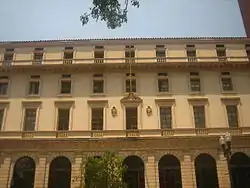 U.S. Post Office and Courthouse |
September 12, 1974 (#74000920) |
424 Texas Street 32°30′48″N 93°44′59″W |
Shreveport | Also contributing property of Shreveport Commercial Historic District since its creation on March 11, 1982.[8] |
| 65 | Booker T. Washington High School | July 14, 2015 (#15000414) |
2104 Milam Street 32°30′19″N 93°46′26″W |
Shreveport | ||
| 66 | Samuel Wiener House | 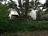 Samuel Wiener House |
September 30, 2004 (#04001079) |
615 Longleaf Road 32°28′03″N 93°44′33″W |
Shreveport | |
| 67 | Wile House | 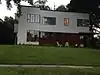 Wile House |
August 5, 1991 (#91001007) |
626 Wilder Place 32°28′35″N 93°44′35″W |
Shreveport | |
| 68 | Wray-Dickinson Building | March 24, 1983 (#83000492) |
308 Market Street 32°30′56″N 93°44′58″W |
Shreveport | Also contributing property of Shreveport Commercial Historic District since its second boundary increase on April 29, 2015.[8] | |
| 69 | YMCA, Downtown Branch | .jpg.webp) YMCA, Downtown Branch |
May 28, 1991 (#91000621) |
400 McNeill Street 32°30′46″N 93°45′05″W |
Shreveport | Also contributing property of Shreveport Commercial Historic District since its first boundary increase on May 16, 1997.[8] |
Former listing
| [3] | Name on the Register | Image | Date listed | Date removed | Location | City or town | Summary |
|---|---|---|---|---|---|---|---|
| 1 | Sidney Herold Mansion | 1978 (#78003197) | 1978 | 840 Jordan Street 32°29′56″N 93°44′51″W |
Shreveport | Demolished in 1978 | |
| 2 | Huey P. Long House | 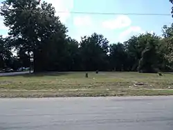 Huey P. Long House |
June 10, 1991 (#91000701) | May 2, 2016 | 2403 Laurel Street 32°29′43″N 93°46′36″W |
Shreveport | Destroyed by fire in September 1992.[20] |
| 3 | Sprague Street Houses | October 3, 1983 (#83003606) | January 31, 2019 | 1100-1118 Sprague Street 32°30′32″N 93°45′21″W |
Shreveport | All houses have been demolished. The last one, at 1118 Sprague Street, on the corner of Christian Street, was torn down in early 2017.[21][22] |
See also
| Wikimedia Commons has media related to National Register of Historic Places in Caddo Parish, Louisiana. |
References
- The latitude and longitude information provided in this table was derived originally from the National Register Information System, which has been found to be fairly accurate for about 99% of listings. Some locations in this table may have been corrected to current GPS standards.
- "National Register of Historic Places: Weekly List Actions". National Park Service, United States Department of the Interior. Retrieved on February 5, 2021.
- Numbers represent an alphabetical ordering by significant words. Various colorings, defined here, differentiate National Historic Landmarks and historic districts from other NRHP buildings, structures, sites or objects.
- "National Register Information System". National Register of Historic Places. National Park Service. March 13, 2009.
- The eight-digit number below each date is the number assigned to each location in the National Register Information System database, which can be viewed by clicking the number.
- "St. Paul's Bottoms" (PDF). State of Louisiana's Division of Historic Preservation. Retrieved April 13, 2018.
- National Register Staff (June 1999). "National Register of Historic Places Registration Form: C.C. Antoine House". National Park Service. pp. 10–15. Retrieved April 10, 2018..
- "Shreveport Commercial Historic District" (PDF). State of Louisiana's Division of Historic Preservation. Archived from the original (PDF) on April 14, 2018. Retrieved April 16, 2018.
- National Register of Historic Places Program: Weekly List - February 23, 2018
- "Highland Historic District" (PDF). State of Louisiana's Division of Historic Preservation. Retrieved April 18, 2018.
- Fairfield Historic District boundary map and District boundaries on Wikimedia Commons
- Highland Historic District boundary map and District boundaries on Wikimedia Commons
- Provident Realty Advisors. "The Ogilvie Hardware Lofts". Retrieved April 13, 2018.
- "Oil City School" (PDF). State of Louisiana's Division of Historic Preservation. Retrieved April 13, 2018. (with 63 photos and two maps)
- St. Paul's Bottoms boundary map, St. Paul's Bottoms boundary map image and District boundaries on Wikimedia Commons
- "Shreveport Commercial Historic District" (PDF). State of Louisiana's Division of Historic Preservation. Archived from the original (PDF) on April 14, 2018. Retrieved April 13, 2018. (with 66 photos and four maps)
- Shreveport Commercial Historic District boundary map and District boundaries on Wikimedia Commons
- "South Highlands Historic District" (PDF). State of Louisiana's Division of Historic Preservation. Retrieved April 17, 2018. (with fifteen photos and two maps)
- South Highlands Historic District boundary map and District boundaries on Wikimedia Commons
- "National Register of Historic Places: Request for Removal - Huey P. Long House" (PDF). National Park Service. March 18, 2016. Retrieved April 18, 2018.
- Gerry May (April 13, 2017). "Historians lament demolition of last historic home on Sprague Row". ktbs.com. Retrieved April 18, 2018.
- The last Sprague Street house, still standing in 2013 and 2014, is visible on StreetView and satellite imagery.
Municipalities and communities of Caddo Parish, Louisiana, United States | ||
|---|---|---|
| City | | |
| Towns | ||
| Villages | ||
| CDP | ||
| Other unincorporated communities |
| |
| Ghost town | ||
| Footnotes | ‡This populated place also has portions in an adjacent parish or parishes | |
| ||
This article is issued from Wikipedia. The text is licensed under Creative Commons - Attribution - Sharealike. Additional terms may apply for the media files.