National Register of Historic Places listings in Chaves County, New Mexico
This is a list of the National Register of Historic Places listings in Chaves County, New Mexico.
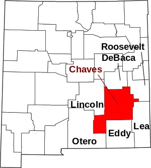
Location of Chaves County in New Mexico
This is intended to be a complete list of the properties and districts on the National Register of Historic Places in Chaves County, New Mexico, United States. Latitude and longitude coordinates are provided for many National Register properties and districts; these locations may be seen together in a map.[1]
There are 20 properties and districts listed on the National Register in the county. All of the places within the county on the National Register are also listed on the State Register of Cultural Properties.
- This National Park Service list is complete through NPS recent listings posted January 29, 2021.[2]
| Bernalillo – Catron – Chaves – Cibola – Colfax – Curry – De Baca – Doña Ana – Eddy – Grant – Guadalupe – Harding – Hidalgo – Lea – Lincoln – Los Alamos – Luna – McKinley – Mora – Otero – Quay – Rio Arriba – Roosevelt – San Juan – San Miguel – Sandoval – Santa Fe – Sierra – Socorro – Taos – Torrance – Union – Valencia |
Current listings
| [3] | Name on the Register[4] | Image | Date listed[5] | Location | City or town | Description |
|---|---|---|---|---|---|---|
| 1 | CA Bar Ranch | August 29, 1988 (#85003634) |
U.S. Route 82 3 miles west of its junction with State Road 24 32°53′38″N 105°13′26″W |
Mayhill | ||
| 2 | Chaves County Courthouse | 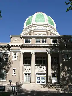 Chaves County Courthouse |
February 15, 1989 (#87000892) |
400 block of Main St. 33°23′49″N 104°31′17″W |
Roswell | |
| 3 | Diamond A Ranch | August 29, 1988 (#85003635) |
About 14 miles west of Roswell along U.S. Route 380, then 2 miles south on a private ranch road 33°21′06″N 104°51′08″W |
Roswell | Ranch headquarters building and bunkhouse built of stone in late 1880s or early 1990s | |
| 4 | Downtown Roswell Historic District | May 16, 1985 (#85001543) |
Roughly bounded by 8th St., Richardson Ave., Albuquerque St., and Missouri Ave. 33°24′05″N 104°31′36″W |
Roswell | ||
| 5 | Flying H Ranch | September 14, 1988 (#85003633) |
Off U.S. Route 70 between Hope and Elk Area 33°00′41″N 105°08′22″W |
Roswell | ||
| 6 | Patrick Floyd Garrett House | August 29, 1988 (#85003637) |
Bosque Rd. 3 miles north of Roswell 33°24′14″N 104°26′17″W |
Roswell | ||
| 7 | Robert H. Goddard House | July 15, 1988 (#85003594) |
Route 3 E. on Mescalero Rd. 33°25′53″N 104°30′07″W |
Roswell | ||
| 8 | The Henge | August 1, 2019 (#100004221) |
3600 La Joya Rd. 33°26′31″N 104°29′55″W |
Roswell vicinity | ||
| 9 | Louise Massey House | 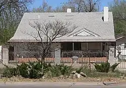 Louise Massey House |
May 16, 1985 (#85001544) |
209 W. Alameda St. 33°23′28″N 104°31′32″W |
Roswell | Home of country singer Louise Massey |
| 10 | Millhiser-Baker Farm | August 29, 1988 (#85003638) |
Route 1 0.5 miles south of McGaffey 33°22′26″N 104°33′04″W |
Roswell | ||
| 11 | Milne-Bush Ranch | August 29, 1988 (#85003639) |
Route 1 33°26′19″N 104°29′55″W |
Roswell | ||
| 12 | New Mexico Military Institute Historic District | 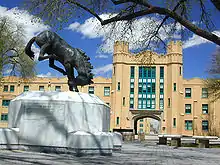 New Mexico Military Institute Historic District |
May 7, 1987 (#87000907) |
Roughly bounded by 19th and N. Main Sts., College Boulevard, and Kentucky Ave. 33°19′52″N 104°31′31″W |
Roswell | |
| 13 | Ozark Trails Marker at Lake Arthur | July 16, 2004 (#04000702) |
Junction of Main and Broadway Sts. 33°00′00″N 104°21′57″W |
Lake Arthur | ||
| 14 | Rio Felix Bridge at Hagerman | July 15, 1997 (#97000737) |
U.S. Route 285 over Rio Felix 33°07′53″N 104°20′11″W |
Hagerman | Pratt through truss three-span bridge | |
| 15 | Roswell Artist-in-Residence Compound | August 7, 2017 (#100001436) |
1404 W. Berrendo Rd. 33°26′16″N 104°32′29″W |
Roswell | ||
| 16 | Saunders-Crosby House | 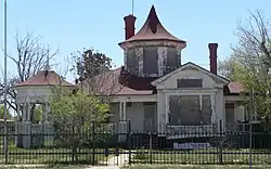 Saunders-Crosby House |
May 16, 1985 (#85001545) |
200 E. Deming 33°23′07″N 104°31′14″W |
Roswell | |
| 17 | Slaughter-Hill Ranch | August 29, 1988 (#85003640) |
1601 E. 2nd St. 33°23′52″N 104°29′47″W |
Roswell | ||
| 18 | South Spring Ranch | April 24, 1989 (#88003465) |
Route 2 33°20′46″N 104°28′10″W |
Roswell | ||
| 19 | Urton Orchards | August 29, 1988 (#85003641) |
Route 3 33°26′04″N 104°29′10″W |
Roswell | ||
| 20 | James Phelps White House | 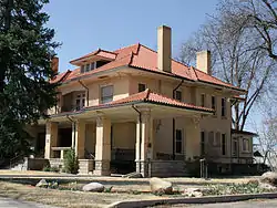 James Phelps White House |
July 24, 1978 (#78001812) |
200 N. Lea Ave. 33°23′40″N 104°31′44″W |
Roswell |
See also
| Wikimedia Commons has media related to National Register of Historic Places in Chaves County, New Mexico. |
References
- The latitude and longitude information provided in this table was derived originally from the National Register Information System, which has been found to be fairly accurate for about 99% of listings. Some locations in this table may have been corrected to current GPS standards.
- "National Register of Historic Places: Weekly List Actions". National Park Service, United States Department of the Interior. Retrieved on January 29, 2021.
- Numbers represent an alphabetical ordering by significant words. Various colorings, defined here, differentiate National Historic Landmarks and historic districts from other NRHP buildings, structures, sites or objects.
- "National Register Information System". National Register of Historic Places. National Park Service. April 24, 2008.
- The eight-digit number below each date is the number assigned to each location in the National Register Information System database, which can be viewed by clicking the number.
| Topics | |
|---|---|
| Lists by state |
|
| Lists by insular areas | |
| Lists by associated state | |
| Other areas | |
| Related | |
| |
Municipalities and communities of Chaves County, New Mexico, United States | ||
|---|---|---|
| City | Map of New Mexico highlighting Chaves County | |
| Towns | ||
| CDP | ||
| Unincorporated community | ||
| Ghost town | ||
| ||
This article is issued from Wikipedia. The text is licensed under Creative Commons - Attribution - Sharealike. Additional terms may apply for the media files.