National Register of Historic Places listings in Otero County, New Mexico
This is a list of the National Register of Historic Places listings in Otero County, New Mexico.
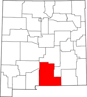
Location of Otero County in New Mexico
This is intended to be a complete list of the properties and districts on the National Register of Historic Places in Otero County, New Mexico, United States. Latitude and longitude coordinates are provided for many National Register properties and districts; these locations may be seen together in a map.[1]
There are 31 properties and districts listed on the National Register in the county. All of the places within the county on the National Register are also listed on the State Register of Cultural Properties.
- This National Park Service list is complete through NPS recent listings posted January 29, 2021.[2]
| Bernalillo – Catron – Chaves – Cibola – Colfax – Curry – De Baca – Doña Ana – Eddy – Grant – Guadalupe – Harding – Hidalgo – Lea – Lincoln – Los Alamos – Luna – McKinley – Mora – Otero – Quay – Rio Arriba – Roosevelt – San Juan – San Miguel – Sandoval – Santa Fe – Sierra – Socorro – Taos – Torrance – Union – Valencia |
Current listings
| [3] | Name on the Register[4] | Image | Date listed[5] | Location | City or town | Description |
|---|---|---|---|---|---|---|
| 1 | Administration Building | 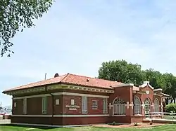 Administration Building |
May 16, 1989 (#88001564) |
1900 N. White Sands Boulevard, New Mexico School for the Blind and Visually Impaired 32°54′51″N 105°57′33″W |
Alamogordo | |
| 2 | Alamogordo Woman's Club | 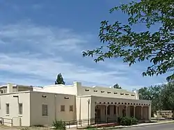 Alamogordo Woman's Club |
August 4, 2003 (#03000734) |
Southeastern corner of the junction of 12th St. and Indiana Ave. 32°54′12″N 105°57′22″W |
Alamogordo | |
| 3 | Archeological Site No. AR-03-08-02-409 | April 13, 1998 (#98000278) |
Address Restricted |
Timberon | ||
| 4 | Archeological Site No. AR-03-08-02-415 | April 13, 1998 (#98000277) |
Address Restricted |
Timberon | ||
| 5 | Archeological Site No. AR-03-08-03-128 | November 24, 1995 (#95001479) |
Address Restricted |
Queen | ||
| 6 | Auditorium and Recreation Building | 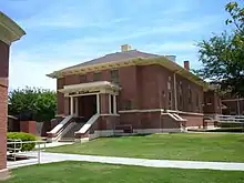 Auditorium and Recreation Building |
May 16, 1989 (#88001565) |
1900 N. White Sands Boulevard, New Mexico School for the Blind and Visually Impaired 32°54′49″N 105°57′30″W |
Alamogordo | |
| 7 | Bluewater Lookout Complex | January 28, 1988 (#87002486) |
Lincoln National Forest 32°44′28″N 105°27′54″W |
Weed | ||
| 8 | Bridge A 249-Cloudcroft, New Mexico | December 29, 2015 (#15000948) |
65 E. Little Mexican Ave. 32°57′36″N 105°44′55″W |
Cloudcroft vicinity | ||
| 9 | Carrisa Lookout Complex | January 28, 1988 (#87002488) |
Lincoln National Forest 32°40′34″N 105°37′09″W |
Long Canyon | ||
| 10 | Central Receiving Building | 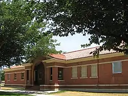 Central Receiving Building |
May 16, 1989 (#88001566) |
1900 N. White Sands Boulevard, New Mexico School for the Blind and Visually Impaired 32°54′51″N 105°57′29″W |
Alamogordo | |
| 11 | Circle Cross Ranch Headquarters | November 17, 1980 (#80002563) |
Southwest of Sacramento 32°39′26″N 105°42′20″W |
Sacramento | ||
| 12 | Fresnal Shelter | April 13, 1998 (#98000315) |
Address Restricted |
High Rolls | ||
| 13 | Juan Garcia House | October 23, 1980 (#80002559) |
Tularosa St. 32°58′40″N 105°56′31″W |
La Luz | ||
| 14 | Hay Canyon Logging Camp | January 2, 1992 (#91001880) |
Address Restricted |
Mayhill | ||
| 15 | Hubbell Canyon Log Chute | December 31, 1991 (#91001882) |
Address Restricted |
Cloudcroft | ||
| 16 | Infirmary Building |  Infirmary Building |
May 16, 1989 (#88001567) |
1900 N. White Sands Boulevard, New Mexico School for the Blind and Visually Impaired 32°55′19″N 105°57′30″W |
Alamogordo | |
| 17 | Jackson House | 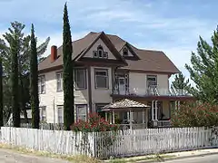 Jackson House |
January 28, 2004 (#03001511) |
1700 9th St. 32°53′56″N 105°56′23″W |
Alamogordo | |
| 18 | La Luz Historic District | 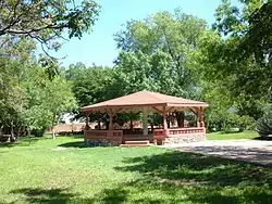 La Luz Historic District |
October 23, 1980 (#80002560) |
Off State Road 83 32°58′42″N 105°56′33″W |
La Luz | |
| 19 | La Luz Pottery Factory | 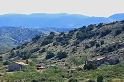 La Luz Pottery Factory |
May 29, 1979 (#79001544) |
2 miles (3.2 km) east of La Luz 32°58′45″N 105°54′08″W |
La Luz | |
| 20 | Oliver Lee Dog Canyon Ranch |  Oliver Lee Dog Canyon Ranch |
May 26, 2015 (#15000263) |
Address Restricted |
Alamogordo vicinity | |
| 21 | Mayhill Administrative Site | June 1, 1989 (#89000476) |
U.S. Route 82, 1.5 miles north of Mayhill 32°54′32″N 105°28′10″W |
Mayhill | ||
| 22 | Mexican Canyon Trestle | 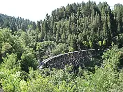 Mexican Canyon Trestle |
May 7, 1979 (#79001543) |
Northwest of Cloudcroft off State Road 83 32°57′49″N 105°44′52″W |
Cloudcroft | Multi-tier railroad trestle bridge, worth stopping at viewpoint for. |
| 23 | Queen Anne House | 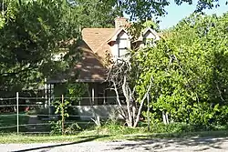 Queen Anne House |
October 23, 1980 (#80002561) |
Kearney St. 32°58′40″N 105°56′31″W |
La Luz | |
| 24 | St. Joseph Apache Mission Church | 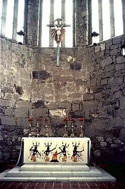 St. Joseph Apache Mission Church |
February 1, 2005 (#04001588) |
626 Mission Trail 33°09′24″N 105°46′03″W |
Mescalero | |
| 25 | D.H. Sutherland House | 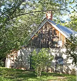 D.H. Sutherland House |
October 23, 1980 (#80002562) |
Main St. 32°58′40″N 105°56′31″W |
La Luz | |
| 26 | Tularosa Original Townsite District | 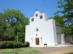 Tularosa Original Townsite District |
February 2, 1979 (#79001545) |
U.S. Routes 54/70 33°04′28″N 106°01′01″W |
Tularosa | |
| 27 | US Post Office-Alamogordo |  US Post Office-Alamogordo |
May 18, 2000 (#00000510) |
1101 New York Ave. 32°54′03″N 105°57′32″W |
Alamogordo | |
| 28 | Weed Lookout Tower | January 28, 1988 (#87002487) |
Lincoln National Forest 32°48′23″N 105°33′33″W |
Sacramento | ||
| 29 | White Sands Historic District |  White Sands Historic District |
June 23, 1988 (#88000751) |
U.S. Routes 70/82 32°46′47″N 106°10′18″W |
Alamogordo | |
| 30 | Wills Canyon Spur Trestle | December 31, 1991 (#91001881) |
Address Restricted |
Cloudcroft | ||
| 31 | Wofford Lookout Complex |  Wofford Lookout Complex |
January 28, 1988 (#87002484) |
Lincoln National Forest 32°59′48″N 105°42′40″W |
Cloudcroft |
See also
| Wikimedia Commons has media related to National Register of Historic Places in Otero County, New Mexico. |
References
- The latitude and longitude information provided in this table was derived originally from the National Register Information System, which has been found to be fairly accurate for about 99% of listings. Some locations in this table may have been corrected to current GPS standards.
- "National Register of Historic Places: Weekly List Actions". National Park Service, United States Department of the Interior. Retrieved on January 29, 2021.
- Numbers represent an alphabetical ordering by significant words. Various colorings, defined here, differentiate National Historic Landmarks and historic districts from other NRHP buildings, structures, sites or objects.
- "National Register Information System". National Register of Historic Places. National Park Service. July 9, 2010.
- The eight-digit number below each date is the number assigned to each location in the National Register Information System database, which can be viewed by clicking the number.
| Topics | |
|---|---|
| Lists by state |
|
| Lists by insular areas | |
| Lists by associated state | |
| Other areas | |
| Related | |
| |
Municipalities and communities of Otero County, New Mexico, United States | ||
|---|---|---|
| City | Map of New Mexico highlighting Otero County | |
| Villages | ||
| CDPs | ||
| Other unincorporated communities | ||
| Indian reservation | ||
| Footnotes | ‡This populated place also has portions in an adjacent county or counties | |
| ||
This article is issued from Wikipedia. The text is licensed under Creative Commons - Attribution - Sharealike. Additional terms may apply for the media files.