National Register of Historic Places listings in San Miguel County, New Mexico
This is a list of the National Register of Historic Places listings in San Miguel County, New Mexico.
This is intended to be a complete list of the properties and districts on the National Register of Historic Places in San Miguel County, New Mexico, United States. Latitude and longitude coordinates are provided for many National Register properties and districts; these locations may be seen together in a map.[1]
There are 102 properties and districts listed on the National Register in the county, including 1 National Historic Landmark of which 1 is also a National Monument. Another 3 properties were once listed but have since been removed. All of the places within the county currently or formerly on the National Register are also recorded on the State Register of Cultural Properties.
- This National Park Service list is complete through NPS recent listings posted January 29, 2021.[2]
| Bernalillo – Catron – Chaves – Cibola – Colfax – Curry – De Baca – Doña Ana – Eddy – Grant – Guadalupe – Harding – Hidalgo – Lea – Lincoln – Los Alamos – Luna – McKinley – Mora – Otero – Quay – Rio Arriba – Roosevelt – San Juan – San Miguel – Sandoval – Santa Fe – Sierra – Socorro – Taos – Torrance – Union – Valencia |
Current listings
| [3] | Name on the Register[4] | Image | Date listed[5] | Location | City or town | Description |
|---|---|---|---|---|---|---|
| 1 | Acequia Madre | March 19, 1987 (#87001118) |
Roughly from the Gallinas River to the intersection of S. Pacific and U.S. Route 85 35°35′05″N 105°13′26″W |
Las Vegas | ||
| 2 | Arturo Angel House | 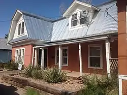 Arturo Angel House |
September 26, 1985 (#85002604) |
926 S. Pacific 35°35′12″N 105°13′22″W |
Las Vegas | |
| 3 | E. N. Charles and Lewis Arthur House | September 26, 1985 (#85002605) |
Douglas Ave. 35°35′37″N 105°13′02″W |
Las Vegas | ||
| 4 | AT & SF Roundhouse | 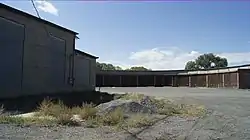 AT & SF Roundhouse |
September 26, 1985 (#85002621) |
Northeast of Grand Ave. 35°35′12″N 105°12′53″W |
Las Vegas | |
| 5 | Baca-Korte House | September 26, 1985 (#85002658) |
615 S. Pacific 35°34′58″N 105°13′15″W |
Las Vegas | ||
| 6 | Bean-Newlee House | _2.JPG.webp) Bean-Newlee House |
September 26, 1985 (#85002625) |
1045 5th St. 35°36′04″N 105°13′04″W |
Las Vegas | |
| 7 | Bell Ranch Headquarters | October 6, 1970 (#70000407) |
North and east of the Conchas Reservoir 35°31′46″N 104°06′00″W |
Tucumcari | ||
| 8 | Bridge Street Historic District | 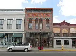 Bridge Street Historic District |
July 26, 1978 (#78001824) |
100 block of Bridge St. 35°35′36″N 105°13′27″W |
Las Vegas | |
| 9 | Building at 1202 9th Street | September 26, 1985 (#85002632) |
1202 9th St. 35°36′02″N 105°13′20″W |
Las Vegas | ||
| 10 | Building at 1214 Bridge |  Building at 1214 Bridge |
September 26, 1985 (#85002660) |
1214 Bridge 35°35′41″N 105°13′22″W |
Las Vegas | |
| 11 | Building at 2005 Montezuma | September 26, 1985 (#85002655) |
2005 Montezuma 35°35′31″N 105°13′57″W |
Las Vegas | ||
| 12 | Building at 1406 Romero | September 26, 1985 (#85002656) |
1406 Romero 35°35′15″N 105°13′51″W |
Las Vegas | ||
| 13 | Lowery Clevenger House | _5.JPG.webp) Lowery Clevenger House |
September 26, 1985 (#85002594) |
1013 2nd 35°36′05″N 105°12′49″W |
Las Vegas | |
| 14 | Conchas Dam Historic District | May 22, 2005 (#05000454) |
Roughly bounded by the State Park South Area, State Park North Area, Conchas Reservoir, and Bell Ranch 35°23′00″N 104°11′47″W |
Conchas Dam | ||
| 15 | James Cook House | _1.JPG.webp) James Cook House |
September 26, 1985 (#85002647) |
1017 11th 35°35′49″N 105°13′23″W |
Las Vegas | |
| 16 | Distrito de las Escuelas |  Distrito de las Escuelas |
March 18, 1980 (#80002567) |
S. Pacific and S. Gonzales Sts. 35°35′32″N 105°13′31″W |
Las Vegas | |
| 17 | Douglas Avenue School |  Douglas Avenue School |
August 5, 1983 (#83001625) |
900 Douglas Ave. 35°35′35″N 105°13′06″W |
Las Vegas | |
| 18 | Douglas-Sixth Street Historic District |  Douglas-Sixth Street Historic District |
July 21, 1983 (#83001626) |
Roughly bounded by Grand, Lincoln, and 7th Sts., and University Ave. 35°35′41″N 105°12′14″W |
Las Vegas | |
| 19 | Eldorado Hotel | 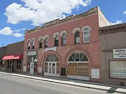 Eldorado Hotel |
September 26, 1985 (#85002626) |
514 Grand 35°35′39″N 105°12′48″W |
Las Vegas | |
| 20 | First Baptist Church | _from_E_1.JPG.webp) First Baptist Church |
September 26, 1985 (#85002612) |
700 University 35°35′44″N 105°13′02″W |
Las Vegas | |
| 21 | Eugenio Gatignole House | September 26, 1985 (#85002606) |
1114 S. Gonzales 35°35′18″N 105°13′24″W |
Las Vegas | ||
| 22 | Esperansa Herrera House | September 26, 1985 (#85002613) |
2231 Church 35°35′41″N 105°13′51″W |
Las Vegas | ||
| 23 | House at 913 2nd | House at 913 2nd |
September 26, 1985 (#85002597) |
913 2nd 35°36′01″N 105°12′47″W |
Las Vegas | southernmost of three adjacent houses, listed together |
| 24 | House at 915 2nd | 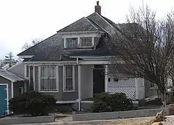 House at 915 2nd |
September 26, 1985 (#85002596) |
915 2nd 35°36′02″N 105°12′48″W |
Las Vegas | Middle one of three adjacent houses, listed together. Free Classic in design, identical in plan to House at 919 2nd. |
| 25 | House at 919 2nd | 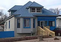 House at 919 2nd |
September 26, 1985 (#85002595) |
919 2nd 35°36′02″N 105°12′48″W |
Las Vegas | northernmost of three adjacent houses, listed together. Free Classic in design, identical in plan to House at 915 2nd. |
| 26 | House at 1513 8th | House at 1513 8th |
September 26, 1985 (#85002634) |
1513 8th 35°36′19″N 105°13′30″W |
Las Vegas | |
| 27 | House at 1616 8th | 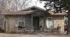 House at 1616 8th |
September 26, 1985 (#85002645) |
1616 8th 35°36′24″N 105°13′31″W |
Las Vegas | |
| 28 | House at 1717 8th | 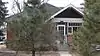 House at 1717 8th |
September 26, 1985 (#85002646) |
1717 8th 35°36′29″N 105°13′36″W |
Las Vegas | |
| 29 | House at 1114 10th | September 26, 1985 (#85002649) |
1114 10th 35°35′53″N 105°13′16″W |
Las Vegas | ||
| 30 | House at 1007 11th Street | 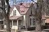 House at 1007 11th Street |
September 26, 1985 (#85002648) |
1007 11th St. 35°35′48″N 105°13′22″W |
Las Vegas | |
| 31 | House at 821 12th | 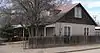 House at 821 12th |
September 26, 1985 (#85002643) |
821 12th 35°35′42″N 105°13′24″W |
Las Vegas | |
| 32 | House at 933 12th | 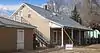 House at 933 12th |
September 26, 1985 (#85002642) |
933 12th 35°35′45″N 105°13′26″W |
Las Vegas | |
| 33 | House at 921 Chavez | September 26, 1985 (#85002653) |
921 Chavez 35°35′09″N 105°13′27″W |
Las Vegas | ||
| 34 | House at 1116 Columbia | 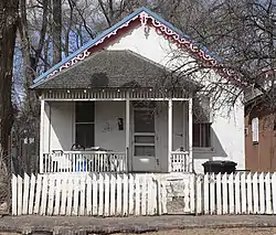 House at 1116 Columbia |
September 26, 1985 (#85002641) |
1116 Columbia 35°35′44″N 105°13′23″W |
Las Vegas | |
| 35 | House at 810 Douglas | 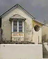 House at 810 Douglas |
September 26, 1985 (#85002603) |
810 Douglas 35°35′47″N 105°13′02″W |
Las Vegas | |
| 36 | House at 812 Douglas |  House at 812 Douglas |
September 26, 1985 (#85002602) |
812 Douglas 35°35′39″N 105°13′02″W |
Las Vegas | |
| 37 | House at 814 Douglas |  House at 814 Douglas |
September 26, 1985 (#85002601) |
814 Douglas 35°35′38″N 105°13′03″W |
Las Vegas | |
| 38 | House at 818 Douglas | 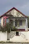 House at 818 Douglas |
September 26, 1985 (#85002600) |
818 Douglas 35°35′38″N 105°13′03″W |
Las Vegas | |
| 39 | House at 822 Douglas | 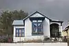 House at 822 Douglas |
September 26, 1985 (#85002599) |
822 Douglas 35°35′38″N 105°13′04″W |
Las Vegas | |
| 40 | House at 12 Grand | 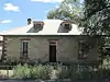 House at 12 Grand |
September 26, 1985 (#85002622) |
12 Grand 35°35′17″N 105°12′54″W |
Las Vegas | |
| 41 | House at 16 Grand | 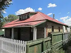 House at 16 Grand |
September 26, 1985 (#85002623) |
16 Grand 35°35′18″N 105°12′53″W |
Las Vegas | |
| 42 | House at 613 Mora | September 26, 1985 (#85002650) |
613 Mora 35°35′45″N 105°14′02″W |
Las Vegas | ||
| 43 | House at 618 Mora | September 26, 1985 (#85002651) |
618 Mora 35°35′21″N 105°14′02″W |
Las Vegas | ||
| 44 | House at 2203 New Mexico | September 26, 1985 (#85002654) |
2203 New Mexico 35°35′40″N 105°13′57″W |
Las Vegas | ||
| 45 | House at 521 S. Pacific |  House at 521 S. Pacific |
September 26, 1985 (#85002659) |
521 S. Pacific 35°34′54″N 105°13′12″W |
Las Vegas | |
| 46 | House at 921 S. Pacific | September 26, 1985 (#85002608) |
921 S. Pacific 35°35′10″N 105°13′22″W |
Las Vegas | ||
| 47 | House at 800 Pecos | September 26, 1985 (#85002633) |
800 Pecos 35°35′48″N 105°12′30″W |
Las Vegas | ||
| 48 | House at 931 Prince | 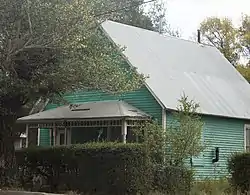 House at 931 Prince |
September 26, 1985 (#85002620) |
931 Prince 35°35′18″N 105°12′59″W |
Las Vegas | |
| 49 | House at 119 Railroad | September 26, 1985 (#85002624) |
119 Railroad 35°35′20″N 105°12′51″W |
Las Vegas | ||
| 50 | House at 309 Railroad | 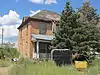 House at 309 Railroad |
September 26, 1985 (#85002628) |
309 Railroad 35°35′29″N 105°12′49″W |
Las Vegas | |
| 51 | House at 733 Railroad | 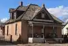 House at 733 Railroad |
September 26, 1985 (#85002629) |
733 Railroad 35°35′52″N 105°12′45″W |
Las Vegas | |
| 52 | House at 919 Railroad | 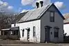 House at 919 Railroad |
September 26, 1985 (#85002630) |
919 Railroad 35°36′01″N 105°12′42″W |
Las Vegas | |
| 53 | House at 1025 Railroad | September 26, 1985 (#85002631) |
1025 Railroad 35°36′06″N 105°12′39″W |
Las Vegas | ||
| 54 | House at 1221 San Francisco | September 26, 1985 (#85002644) |
1221 San Francisco 35°35′49″N 105°13′28″W |
Las Vegas | ||
| 55 | House at 2501 Taos Alley | September 26, 1985 (#85002652) |
2501 Taos Alley 35°35′48″N 105°14′05″W |
Las Vegas | ||
| 56 | House at 312 Tecolote | 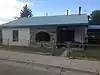 House at 312 Tecolote |
September 26, 1985 (#85002609) |
312 Tecolote 35°35′10″N 105°13′25″W |
Las Vegas | |
| 57 | House at 508 University | House at 508 University |
September 26, 1985 (#85002611) |
508 University 35°35′47″N 105°12′54″W |
Las Vegas | |
| 58 | House at 514 University | 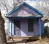 House at 514 University |
September 26, 1985 (#85002610) |
514 University 35°35′47″N 105°12′55″W |
Las Vegas | |
| 59 | Adele Ilfeld Auditorium | _from_SW_1.JPG.webp) Adele Ilfeld Auditorium |
January 8, 1980 (#80002568) |
900 University Avenue[6] 35°35′41″N 105°13′11″W |
Las Vegas | |
| 60 | Charles Ilfeld Memorial Chapel | September 26, 1985 (#85002657) |
Colonias and Romero 35°35′48″N 105°14′16″W |
Las Vegas | ||
| 61 | Johnsen House | _from_NE_2.JPG.webp) Johnsen House |
September 26, 1985 (#85002635) |
1523 8th 35°36′20″N 105°13′31″W |
Las Vegas | |
| 62 | Johnsen Mortuary | 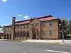 Johnsen Mortuary |
September 26, 1985 (#85002607) |
801 Douglas 35°35′37″N 105°13′00″W |
Las Vegas | |
| 63 | Norman L. King Memorial Stadium | September 17, 1999 (#99001172) |
2.7 miles northwest of the junction of State Road 65 and Mill Ave. 35°36′40″N 105°15′31″W |
Las Vegas | ||
| 64 | Las Vegas Municipal Building | 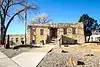 Las Vegas Municipal Building |
October 24, 2007 (#07001107) |
727 Grand Ave. 35°35′52″N 105°12′47″W |
Las Vegas | |
| 65 | Las Vegas Plaza | 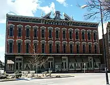 Las Vegas Plaza |
December 16, 1974 (#74001202) |
Bounded by Valencia and Moreno Sts. and the rear property line of the building on Gonzales St. and Hot Springs Boulevard 35°35′34″N 105°13′35″W |
Las Vegas | |
| 66 | Las Vegas Railroad and Power Company Building | September 26, 1985 (#85002640) |
12th and San Francisco 35°35′52″N 105°13′25″W |
Las Vegas | ||
| 67 | Library Park Historic District | 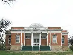 Library Park Historic District |
March 12, 1979 (#79001549) |
Liberty Park and environs 35°35′52″N 105°12′52″W |
Las Vegas | |
| 68 | Lincoln Park Historic District | 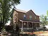 Lincoln Park Historic District |
August 6, 1979 (#79001550) |
7th, 8th, Lincoln and Jackson Sts 35°35′33″N 105°12′57″W |
Las Vegas | |
| 69 | Montezuma Hotel Complex | 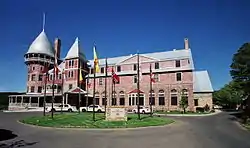 Montezuma Hotel Complex |
May 3, 1974 (#74001203) |
6 miles northwest of Las Vegas in Gallinas Canyon 35°39′15″N 105°16′53″W |
Las Vegas | |
| 70 | Nolan House | September 26, 1985 (#85002619) |
110 10th St. 35°35′22″N 105°13′03″W |
Las Vegas | ||
| 71 | North New Town Historic District | 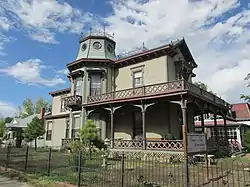 North New Town Historic District |
August 18, 1983 (#83001627) |
Roughly bounded by National, Friedman, 3rd, and 8th Sts. 35°35′58″N 105°13′05″W |
Las Vegas | |
| 72 | Old Las Vegas Post Office | 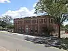 Old Las Vegas Post Office |
September 26, 1985 (#85002598) |
901 Douglas 35°35′36″N 105°13′05″W |
Las Vegas | |
| 73 | Old Town Residential Historic District | 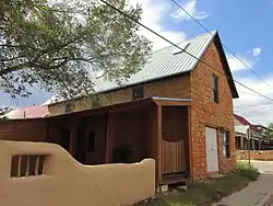 Old Town Residential Historic District |
October 28, 1983 (#83004161) |
Roughly bounded by Perey St. to Mills Ave., and from New Mexico to Gonzales St. 35°35′31″N 105°13′42″W |
Las Vegas | |
| 74 | Our Lady of Sorrows Church | _06.jpg.webp) Our Lady of Sorrows Church |
September 8, 1976 (#76001197) |
W. National Ave. 35°35′31″N 105°13′43″W |
Las Vegas | |
| 75 | Park Springs Ranch Headquarters Complex | November 28, 2008 (#08001137) |
11.6 miles east of junction US 84 and NM 451 35°15′56″N 104°55′49″W |
Dilia | ||
| 76 | Pecos National Historical Park | 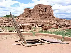 Pecos National Historical Park |
October 15, 1966 (#66000485) |
State Road 63 southwest of its junction with State Road 50 35°33′00″N 105°41′04″W |
Pecos | Main portion in this county was designated a National Historic Landmark District on July 2, 1991. Glorieta Pass Battlefield portion of park is in Santa Fe County. |
| 77 | Pecos River Bridge at Terrero | 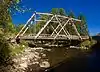 Pecos River Bridge at Terrero |
July 15, 1997 (#97000739) |
State Road 63 over the Pecos River 35°44′26″N 105°40′40″W |
Terrero | |
| 78 | Pendaries Grist Mill | February 2, 1979 (#79001552) |
1 mile (1.6 km) east of Rociada off State Road 105 35°50′35″N 105°23′45″W |
Rociada | ||
| 79 | Pimter-O'Neil Rooming House | 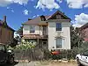 Pimter-O'Neil Rooming House |
September 26, 1985 (#85002627) |
313 Railroad 35°35′31″N 105°12′49″W |
Las Vegas | |
| 80 | Presbyterian Mission Church | 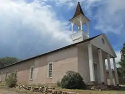 Presbyterian Mission Church |
November 17, 1978 (#78001825) |
1413 Chavez St. 35°35′22″N 105°13′34″W |
Las Vegas | |
| 81 | Railroad Avenue Historic District | 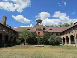 Railroad Avenue Historic District |
August 6, 1979 (#79001551) |
U.S. Route 85 35°35′38″N 105°12′45″W |
Las Vegas | |
| 82 | Rogers Administration Building | 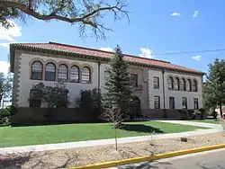 Rogers Administration Building |
September 22, 1988 (#88001559) |
National Ave., on the New Mexico Highlands University campus 35°35′43″N 105°13′10″W |
Las Vegas | |
| 83 | Rowe Pueblo | May 26, 2000 (#00000547) |
Address Restricted |
Rowe | ||
| 84 | St. Anthony's Hospital Annex | September 26, 1985 (#85002592) |
700 Friedman 35°36′10″N 105°13′19″W |
Las Vegas | ||
| 85 | St. Paul's Memorial Episcopal Church and Guild Hall | 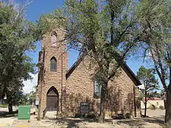 St. Paul's Memorial Episcopal Church and Guild Hall |
November 7, 1976 (#76001198) |
714-716 National Ave. 35°35′46″N 105°13′04″W |
Las Vegas | |
| 86 | Vidal and Elisa Salazar House | September 26, 1985 (#85002637) |
824 Railroad 35°35′55″N 105°12′39″W |
Las Vegas | ||
| 87 | San Antonio de Padua Church | 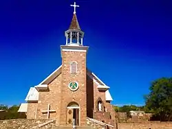 San Antonio de Padua Church |
September 13, 1978 (#78001826) |
State Road 63 35°34′59″N 105°40′31″W |
Pecos | |
| 88 | San Geronimo Historic District | November 15, 1983 (#83004163) |
Off State Road 283 35°34′47″N 105°23′44″W |
San Geronimo | ||
| 89 | San Miguel del Vado Historic District | 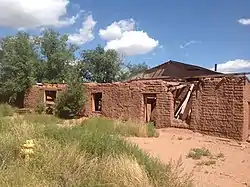 San Miguel del Vado Historic District |
July 17, 1972 (#72000809) |
Southeast of San Jose on State Road 3, off U.S. Route 84 35°21′47″N 105°27′01″W |
San Jose | |
| 90 | Santa Fe Trail-San Miguel County Trail Segments | April 21, 1994 (#94000326) |
West of Interstate 25, south of Tecolote 35°27′08″N 105°16′49″W |
Tecolote | ||
| 91 | Santa Fe Trail-West San Jose Segment | August 8, 2014 (#14000481) |
Address restricted |
San Jose | ||
| 92 | Schmitt-Laemmle House | Schmitt-Laemmle House |
September 26, 1985 (#85002639) |
1106 Columbia 35°35′45″N 105°13′21″W |
Las Vegas | House no longer there; site occupied by parking lot |
| 93 | Serna-Blanchard House | September 26, 1985 (#85002614) |
2203 N. Gonzales 35°35′46″N 105°13′41″W |
Las Vegas | ||
| 94 | Shawn-Guerin House | September 26, 1985 (#85002615) |
140 Delgado 35°35′47″N 105°13′39″W |
Las Vegas | ||
| 95 | M. M. Sundt House | _from_E_1.JPG.webp) M. M. Sundt House |
September 26, 1985 (#85002638) |
1607 8th 35°36′22″N 105°13′32″W |
Las Vegas | |
| 96 | Taichert Building |  Taichert Building |
September 26, 1985 (#85002616) |
1201 National 35°35′37″N 105°13′20″W |
Las Vegas | |
| 97 | Taichert Warehouse | 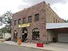 Taichert Warehouse |
September 26, 1985 (#85002618) |
623 12th 35°35′35″N 105°13′19″W |
Las Vegas | |
| 98 | Tipton-Black Willow Ranch Historic District | June 29, 2001 (#00001287) |
3 miles east of Watrous 35°47′28″N 104°55′34″W |
Watrous | Extends into Mora County, New Mexico, too. | |
| 99 | Truder Park | September 26, 1985 (#85002661) |
Roughly bounded by 2nd, Washington, and Grand 35°36′03″N 105°12′43″W |
Las Vegas | ||
| 100 | Trujillo-Gonzales House | September 26, 1985 (#85002617) |
935 New Mexico 35°35′10″N 105°13′36″W |
Las Vegas | ||
| 101 | Valencia Ranch Historic Archaeological District | February 9, 1984 (#84002975) |
Address Restricted |
Pecos | ||
| 102 | Variadero Bridge | 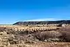 Variadero Bridge |
July 22, 1997 (#97000736) |
State Road 104 over Rio Conchas 35°23′21″N 104°27′33″W |
Variadero | |
| 103 | C. W. G. Ward House | _from_NE_1.JPG.webp) C. W. G. Ward House |
September 26, 1985 (#85002593) |
1301 8th 35°36′09″N 105°13′23″W |
Las Vegas |
Former listings
| [3] | Name on the Register | Image | Date listed | Date removed | Location | City or town | Summary |
|---|---|---|---|---|---|---|---|
| 1 | Elks Lodge Building | February 28, 1985 (#85000377) | June 10, 1998 | 819 Douglas Avenue |
Las Vegas | Gutted by fire in 1997 and later demolished. | |
| 2 | Las Vegas Armory | 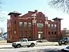 Las Vegas Armory |
1983 (#83004160) | March 10, 1994 | 917 Douglas Avenue 35°36′08″N 105°13′26″W |
Las Vegas | Most of the building was destroyed in a fire in 1993 but the front section is still standing. |
| 3 | Las Vegas Iron Works | September 26, 1985 (#85002636) | July 3, 1996 | Off NM 65/104 |
Las Vegas |
See also
| Wikimedia Commons has media related to National Register of Historic Places in San Miguel County, New Mexico. |
References
- The latitude and longitude information provided in this table was derived originally from the National Register Information System, which has been found to be fairly accurate for about 99% of listings. Some locations in this table may have been corrected to current GPS standards.
- "National Register of Historic Places: Weekly List Actions". National Park Service, United States Department of the Interior. Retrieved on January 29, 2021.
- Numbers represent an alphabetical ordering by significant words. Various colorings, defined here, differentiate National Historic Landmarks and historic districts from other NRHP buildings, structures, sites or objects.
- "National Register Information System". National Register of Historic Places. National Park Service. April 24, 2008.
- The eight-digit number below each date is the number assigned to each location in the National Register Information System database, which can be viewed by clicking the number.
- "Campus Building Addresses". New Mexico Highlands University. Retrieved 2012-02-23.
| Topics | |
|---|---|
| Lists by state |
|
| Lists by insular areas | |
| Lists by associated state | |
| Other areas | |
| Related | |
| |
Municipalities and communities of San Miguel County, New Mexico, United States | ||
|---|---|---|
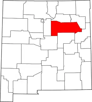
| City | Map of New Mexico highlighting San Miguel County | |
| Villages | ||
| CDPs | ||
| Other unincorporated communities | ||
| Ghost towns | ||
| Footnotes | ‡This populated place also has portions in an adjacent county or counties | |
| ||