National Register of Historic Places listings in Union County, New Mexico
This is a list of the National Register of Historic Places listings in Union County, New Mexico.
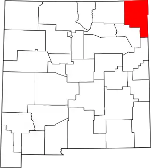
Location of Union County in New Mexico
This is intended to be a complete list of the properties and districts on the National Register of Historic Places in Union County, New Mexico, United States. Latitude and longitude coordinates are provided for many National Register properties and districts; these locations may be seen together in a map.[1]
There are 10 properties and districts listed on the National Register in the county, including 1 National Historic Landmark. One former site on the Register is located within the county. All of the places within the county on the National Register are also listed on the State Register of Cultural Properties.
- This National Park Service list is complete through NPS recent listings posted January 29, 2021.[2]
| Bernalillo – Catron – Chaves – Cibola – Colfax – Curry – De Baca – Doña Ana – Eddy – Grant – Guadalupe – Harding – Hidalgo – Lea – Lincoln – Los Alamos – Luna – McKinley – Mora – Otero – Quay – Rio Arriba – Roosevelt – San Juan – San Miguel – Sandoval – Santa Fe – Sierra – Socorro – Taos – Torrance – Union – Valencia |
Current listings
| [3] | Name on the Register[4] | Image | Date listed[5] | Location | City or town | Description |
|---|---|---|---|---|---|---|
| 1 | Amistad Gymnasium | 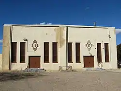 Amistad Gymnasium |
March 15, 1996 (#96000264) |
0.5 miles east of State Road 402 35°55′12″N 103°09′13″W |
Amistad | |
| 2 | Clayton Public Library | 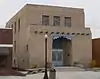 Clayton Public Library |
December 20, 2002 (#02001550) |
116 Walnut St. 36°27′03″N 103°10′59″W |
Clayton | |
| 3 | Clayton Public Schools Historic District | 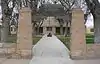 Clayton Public Schools Historic District |
March 15, 1996 (#96000269) |
Four blocks in southeastern Clayton centered on 6th and Cedar Sts. 36°26′59″N 103°10′33″W |
Clayton | |
| 4 | Eklund Hotel | 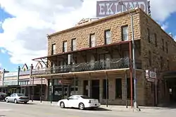 Eklund Hotel |
January 17, 2002 (#01001470) |
15 Main St. 36°27′06″N 103°11′03″W |
Clayton | |
| 5 | Folsom Hotel | 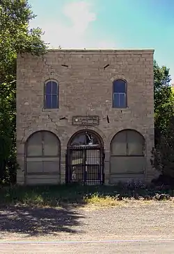 Folsom Hotel |
May 14, 1987 (#87000726) |
Southwestern corner of the junction of Grand Ave. and Wall St. 36°50′41″N 103°55′08″W |
Folsom | |
| 6 | Gate, Fence and Hollow Tree Shelter Designed by Dionicio Rodriguez | 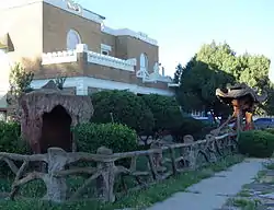 Gate, Fence and Hollow Tree Shelter Designed by Dionicio Rodriguez |
November 25, 2008 (#08001138) |
320 Oak St. 36°27′01″N 103°10′49″W |
Clayton | |
| 7 | Goodson Memorial School |  Goodson Memorial School |
January 8, 2003 (#02001693) |
State Road 456, approximately 4 miles west of its junction with State Road 406 36°55′07″N 103°05′30″W |
Seneca | |
| 8 | Luna Theater |  Luna Theater |
January 17, 2007 (#06001252) |
2-6 Main St. 36°27′11″N 103°11′07″W |
Clayton | |
| 9 | Rabbit Ears | 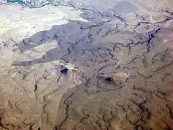 Rabbit Ears |
October 15, 1966 (#66000499) |
Northwest of Clayton 36°35′32″N 103°13′28″W |
Clayton | |
| 10 | Union County Courthouse | 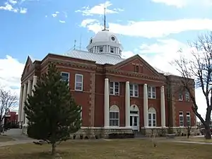 Union County Courthouse |
December 7, 1987 (#87000891) |
Court St. 36°26′58″N 103°11′13″W |
Clayton |
Former listing
| [3] | Name on the Register | Image | Date listed | Date removed | Location | City or town | Summary |
|---|---|---|---|---|---|---|---|
| 1 | McNees Crossing Site | March 25, 1971 (#70000903) | N. Canadian River near State Road 18 |
Seneca |
See also
| Wikimedia Commons has media related to National Register of Historic Places in Union County, New Mexico. |
References
- The latitude and longitude information provided in this table was derived originally from the National Register Information System, which has been found to be fairly accurate for about 99% of listings. Some locations in this table may have been corrected to current GPS standards.
- "National Register of Historic Places: Weekly List Actions". National Park Service, United States Department of the Interior. Retrieved on January 29, 2021.
- Numbers represent an alphabetical ordering by significant words. Various colorings, defined here, differentiate National Historic Landmarks and historic districts from other NRHP buildings, structures, sites or objects.
- "National Register Information System". National Register of Historic Places. National Park Service. July 9, 2010.
- The eight-digit number below each date is the number assigned to each location in the National Register Information System database, which can be viewed by clicking the number.
| Topics | |
|---|---|
| Lists by state |
|
| Lists by insular areas | |
| Lists by associated state | |
| Other areas | |
| Related | |
| |
Municipalities and communities of Union County, New Mexico, United States | ||
|---|---|---|
| Town | Map of New Mexico highlighting Union County | |
| Villages | ||
| CDP | ||
| Other unincorporated communities | ||
| ||
This article is issued from Wikipedia. The text is licensed under Creative Commons - Attribution - Sharealike. Additional terms may apply for the media files.