National Register of Historic Places listings in Valencia County, New Mexico
This is a list of the National Register of Historic Places listings in Valencia County, New Mexico.
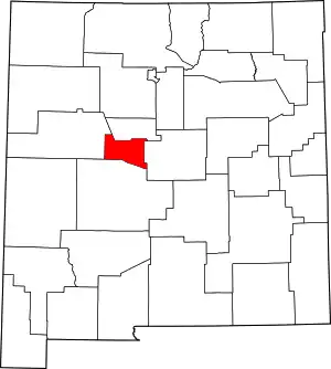
Location of Valencia County in New Mexico
This is intended to be a complete list of the properties and districts on the National Register of Historic Places in Valencia County, New Mexico, United States. Latitude and longitude coordinates are provided for many National Register properties and districts; these locations may be seen together in a map.[1]
There are 12 properties and districts listed on the National Register in the county. All of the places within the county listed on the National Register are also recorded on the State Register of Cultural Properties.
- This National Park Service list is complete through NPS recent listings posted January 29, 2021.[2]
| Bernalillo – Catron – Chaves – Cibola – Colfax – Curry – De Baca – Doña Ana – Eddy – Grant – Guadalupe – Harding – Hidalgo – Lea – Lincoln – Los Alamos – Luna – McKinley – Mora – Otero – Quay – Rio Arriba – Roosevelt – San Juan – San Miguel – Sandoval – Santa Fe – Sierra – Socorro – Taos – Torrance – Union – Valencia |
Current listings
| [3] | Name on the Register[4] | Image | Date listed[5] | Location | City or town | Description |
|---|---|---|---|---|---|---|
| 1 | Atchison, Topeka, and Santa Fe Railroad Depot | 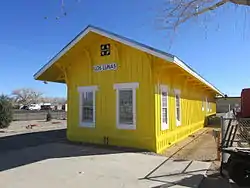 Atchison, Topeka, and Santa Fe Railroad Depot |
August 1, 1979 (#79001562) |
New Mexico State Road 314 34°47′42″N 106°44′20″W |
Los Lunas | Atchison, Topeka & Santa Fe Railroad depot built in 1879, the oldest of its standard design in New Mexico |
| 2 | Miguel E. Baca House | 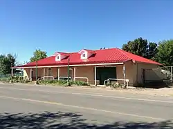 Miguel E. Baca House |
December 11, 1978 (#78001835) |
State Road 47 34°42′42″N 106°43′49″W |
Adelino | |
| 3 | Belen City Hall |  Belen City Hall |
April 29, 2019 (#100003676) |
503 Becker Ave. 34°39′37″N 106°46′24″W |
Belen | |
| 4 | Belen Hotel | 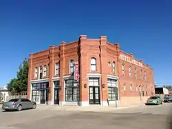 Belen Hotel |
November 12, 1980 (#80002574) |
200 Becker Ave. 34°39′36″N 106°46′08″W |
Belen | |
| 5 | Felipe Chaves House | 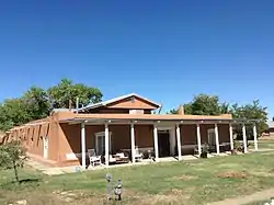 Felipe Chaves House |
July 4, 1980 (#80002575) |
325 Lala St. 34°39′44″N 106°46′38″W |
Belen | |
| 6 | El Cerro Tome Site | 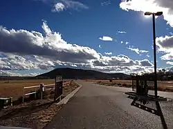 El Cerro Tome Site |
July 9, 1996 (#96000739) |
0.5 miles east of the junction of State Road 47 and Tome Hill Rd. 34°45′20″N 106°42′19″W |
Tome | |
| 7 | Belen Harvey House | 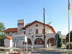 Belen Harvey House |
October 28, 1983 (#83004180) |
104 N. 1st St. 34°39′36″N 106°46′02″W |
Belen | |
| 8 | Los Ojuelos (The Springs) | December 10, 1987 (#87002080) |
Address Restricted |
Tome | ||
| 9 | Tranquilino Luna House | April 16, 1975 (#75001175) |
Southwest of Los Lunas at the junction of U.S. Route 85 and State Road 6 34°48′26″N 106°44′08″W |
Los Lunas | ||
| 10 | Otero's 66 Service | 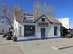 Otero's 66 Service |
February 13, 2003 (#03000051) |
100 W. Main St. 34°48′26″N 106°44′03″W |
Los Lunas | |
| 11 | Tome Jail | 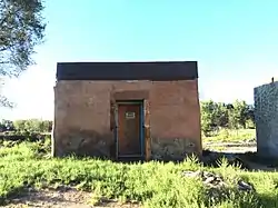 Tome Jail |
October 5, 1977 (#77000932) |
Tome Plaza 34°44′26″N 106°43′49″W |
Tome | |
| 12 | Dr. William Frederick Wittwer House | February 27, 1987 (#87000131) |
State Road 6, west of U.S. Route 85 34°48′29″N 106°44′09″W |
Los Lunas |
See also
| Wikimedia Commons has media related to National Register of Historic Places in Valencia County, New Mexico. |
References
- The latitude and longitude information provided in this table was derived originally from the National Register Information System, which has been found to be fairly accurate for about 99% of listings. Some locations in this table may have been corrected to current GPS standards.
- "National Register of Historic Places: Weekly List Actions". National Park Service, United States Department of the Interior. Retrieved on January 29, 2021.
- Numbers represent an alphabetical ordering by significant words. Various colorings, defined here, differentiate National Historic Landmarks and historic districts from other NRHP buildings, structures, sites or objects.
- "National Register Information System". National Register of Historic Places. National Park Service. July 9, 2010.
- The eight-digit number below each date is the number assigned to each location in the National Register Information System database, which can be viewed by clicking the number.
| Topics | |
|---|---|
| Lists by state |
|
| Lists by insular areas | |
| Lists by associated state | |
| Other areas | |
| Related | |
| |
Municipalities and communities of Valencia County, New Mexico, United States | ||
|---|---|---|
| Cities | Map of New Mexico highlighting Valencia County | |
| Town | ||
| Villages | ||
| CDPs | ||
| Unincorporated community | ||
| ||
This article is issued from Wikipedia. The text is licensed under Creative Commons - Attribution - Sharealike. Additional terms may apply for the media files.