Peren district
Peren (Pron:/ˈpɛɹən or pəˈɹɛn /) is the eleventh district of Nagaland and has been formed by the partition of Kohima district.
Peren district | |
|---|---|
District | |
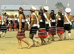 A Liangmai dance in Peren | |
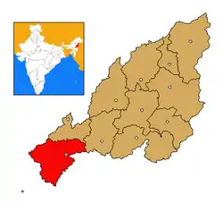 Peren district's location in Nagaland | |
| Coordinates: 25°31′N 93°44′E | |
| State | Nagaland |
| Country | India |
| Seat | Peren |
| Area | |
| • Total | 2,300 km2 (900 sq mi) |
| Elevation | 1,445 m (4,741 ft) |
| Population (2011) | |
| • Total | 95,219 |
| • Density | 41/km2 (110/sq mi) |
| Time zone | UTC+05:30 (IST) |
| ISO 3166 code | IN-NL-PE |
| Website | http://peren-district.nic.in/ |
History
The Peren district was originally a sub-division of the Kohima district. It was declared a separate district on 24 October 2003.[1]
Geography
It is bounded by Dima Hasao and Karbi Anglong districts of Assam in the west and Dimapur district to the north-east. Kohima district in the east and Tamenglong district of Manipur in the south are the other boundaries.
It is headquartered at New Peren. The altitude of the district varies from 800 m to 2,500 m above the sea level. The principal rivers and important rivulets that flow through Peren district include Tepuiki, Mbeiki (Barak), Ntanki, Manglou, Tesanki, Selseu , Nguiki, Nkwareu, Techauki, Ngungreu, Tahaiki and Duilumreu (Tributary of Tepuiki). Mt. Paona at 2,500 m high is the highest mountain peak in the district and third highest in Nagaland. Tening, Jalukie, Peren and Ahthibung are the major towns of the district.
Demographics
According to the 2011 census, Peren district has a population of 95,219,[2] roughly equal to the nation of Seychelles.[3] This gives it a ranking of 616th in India (out of a total of 640).[2] Peren has a sex ratio of 917 females for every 1000 males,[2] and a literacy rate of 79%.[2]
Peren district the home of the Zeliang Naga Tribe and Kuki people. The languages spoken are the Zeme, Liangmai, Rongmei and kuki, Nagamese along with English the official language of Nagaland. Though in the past they were headhunters, christianity brought the new light of modernity & civility. The people of Peren district are well-known for the best dance, music, arts and fineries. Of late, for want of more economic development in the district people are striving with negligible support from the government, for which the people of Peren district are reeling under acute poverty and are now a backward district in Nagaland[4]
Flora and fauna
In Peren district is the home to Ntangki National Park, which has an area of 202 km2 (78.0 sq mi).[5]
Subdivisions
There are two main Sub-division viz- Jalukie and Tening sub-divisions.
References
- "District Census Handbook - Peren" (PDF). 2011 Census of India. Directorate of Census Operations, Nagaland. Retrieved 22 July 2015.
- "District Census 2011". Census2011.co.in. 2011. Retrieved 30 September 2011.
- US Directorate of Intelligence. "Country Comparison: Population". Retrieved 1 October 2011.
Seychelles 89,188 July 2011 est.
- https://peren-district.nic.in/about-district/
- Indian Ministry of Forests and Environment. "Protected areas: Nagaland". Archived from the original on 23 August 2011. Retrieved 25 September 2011.
External links
Places adjacent to Peren district | |
|---|---|
| State symbols | |
|---|---|
| Governance | |
| Topics | |
| Divisions |
|
| Districts | |
| Main cities and towns | |
