Saint Brelade
Saint Brelade (French: Saint Brélade) is one of the twelve parishes of Jersey in the Channel Islands. It is around 7 kilometres (4.3 mi)[lower-alpha 1] west of St Helier. Its population was 10,568 as of 2011.[2]
Saint Brelade | |
|---|---|
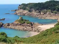 St. Brelade's coastline of promontories and bays includes Portelet and its tidal island, L'Île au Guerdain with Portelet Tower (also known as Janvrin's Tomb) | |
 Coat of arms | |
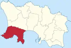 Location of Saint Brelade in Jersey | |
| Crown Dependency | Jersey, Channel Islands |
| Government | |
| • Connétable | Michael Jackson |
| Area | |
| • Total | 12.8 km2 (4.9 sq mi) |
| Area rank | Ranked 2nd |
| Population (2011) | |
| • Total | 10,568 |
| • Density | 830/km2 (2,100/sq mi) |
| Time zone | GMT |
| • Summer (DST) | UTC+01 |
| Postcode district | |
| Postcode sector | 8 |
| Website | www |
The parish is the second-largest parish by surface area, covering 7,103 vergées (3,157 acres or 12.78 km2), which is 11% of the total land surface of the island and it occupies the southwestern part of the island. It is the only parish to border only one other parish, St. Peter.
The parish is largely a suburban commuter area for St Helier, with expansive low rise residential development, especially in the area of Les Quennevais. However, the parish also has a number of notable natural sites, such as the sand dunes of St Ouen's Bay.
History
Its name is derived from a 6th-century Celtic or Welsh "wandering saint" named Branwalator or Saint Brelade (also Branwallder, Broladre, Brelodre, Brélade), who is said to have been the son of the Cornish king, Kenen. He is also said to have been a disciple of Samson of Dol, and worked with this churchman in Cornwall and the Channel Islands. A large section of the Jersey Railway linking La Corbière with Saint Helier ran through the parish between 1870 and 1936.
The village of St Aubin is named for St Aubin, Bishop of Angers in France.
The Jersey parish system has been in place for centuries. By Norman times, the parish boundaries were firmly fixed and remain largely unchanged since.[3]
In 1180 Jersey was divided by the Normans into three ministeria for administrative purposes. St Brelade was part of Crapoudoit. Crapoudoit likely refers to the stream running through St Peter's Valley.[3]
Governance
The parish is divided into vingtaines for administrative purposes as follows:
St. Brelade is divided into two electoral districts:
- St. Brelade No. 1 district (Vingtaines de Noirmont and du Coin) elects one Deputy
- St. Brelade No. 2 district (Vingtaines des Quennevais and de la Moye) elects two Deputies.
Geography
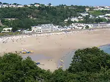
St Brelade is in the south-west of the island of Jersey, part of the Channel Islands archipelago. It borders only one parish, St Peter, and is the only parish to do so. It is located 4.7 kilometres (2.9 mi) west of St Helier. The parish has a number of popular bays, St. Brelade's Bay, Ouaisné, Portelet and parts of both St. Ouen's Bay and St. Aubin's Bay falling within the parish boundaries.
The parish is quite urbanised, with 29% of the land area being built environment. It is also the least agricultural, with only 24% of the parish dedicated to cultivation. However, 38% dedicated to the natural environment, as the parish has notable natural coastal areas.[4]
The parish's population is largely centred around three primary areas of development. The largest is the Les Quennevais area, developed largely in incorporating St Brelade's Bay. This area has a number of shops, a leisure centre and a secondary school. The other areas are the developments around Noirmont and Mont Nicolle and the village of St Aubin, the historic centre of the parish - originally a fishing port facing St. Helier on the opposite side of St. Aubin's Bay.
Culture
The traditional nickname for St. Bréladaises (inhabitants of St. Brelade) is carpéleuses (caterpillars).
Landmarks
Jersey's prison is situated at La Moye, and the island's desalination plant is also sited in the parish.
St Aubin's Fort is located on an islet in St Aubin's Bay. It was built at the command of Sir Henry Cornish in 1542. It became a fort in 1643, during the English Civil War. The islet was refortified during the Occupation.[5]
The lighthouse at La Corbière features on the Jersey £5 note (see Jersey pound) and the Jersey 20-pence piece (see coins of the Jersey pound). "La Corbière" means the place of ravens or crows. This corner of the island had a fearsome reputation amongst sailors and was the scene of many wrecks. The lighthouse was constructed in 1873, designed by Sir John Coode. A causeway connects the lighthouse to the mainland but is cut off for large parts of the day.[6]
Demographics
| Year | Pop. | ±% |
|---|---|---|
| 1991 | 9,331 | — |
| 1996 | 9,560 | +2.5% |
| 2001 | 10,134 | +6.0% |
| 2011 | 10,568 | +4.3% |
Church
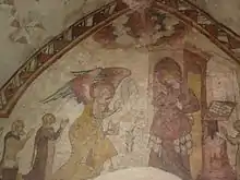
St Brelade's Church is situated at the end of St. Brelade's Bay, an unusual situation being comparatively distant from historic centres of population. The small Fisherman's Chapel alongside contains mediaeval frescoes which survived the iconoclasm of the Reformation. According to folklore, the reason for the siting of the parish church is that originally the St. Bréladais intended to build the church inland, much nearer to the homes of the congregation. However les p'tits faîtchieaux (the little people) who had their temple in a nearby dolmen were disturbed by the construction of the foundations and, every night, would undo the construction work and magically transport all the tools and materials down to the shoreline. Eventually the humans gave up and built the church where the fairies had indicated.
Another church is located close to the Parish Hall in Saint Aubin. St Aubin on the Hill is an Anglican church in the Parish of Saint Brelade dedicated to Saint Aubin of Angers. The church that stands today was built in the 19th century and is a fine example of Victorian Gothic style, with beautiful stained glass windows. When this was built the appointed minister of the Anglican church also supported the building of a local primary school just a short walk from the church. St Brelade's School served the whole parish until it closed in 1984 and became St Brelade's College, a school that teaches English to foreign pupils.
Notable residents
- Isaac LeVesconte (12 August 1822 – 26 October 1879), Nova Scotia businessman and political figure.
- Michael Jackson was elected Connétable of the Parish of St Brelade in 2019.</ref>
- Charles Robin
- Robert Pipon Marett, of La Haule Manor
- Claude Cahun
- André Gide
- Simon Laurens
- Derek Warwick, former British Formula One driver
- Ronald Price Hickman, car designer and inventor who designed the original Lotus Elan, the Lotus Elan +2 and the Lotus Europa, as well as the Black & Decker Workmate.
- Bob Murray (businessman) businessman and former chairman of Sunderland A.F.C. An accountant by trade, he made his fortune through the growth and sale of the Spring Ram kitchen manufacturing company.
- Jack Higgins, pseudonym of British novelist Harry Patterson, author of The Eagle Has Landed
Awards
In 2009 the parish won a Britain in Bloom award in the small coastal resort category.[7] Britain in Bloom awards too in 2012, 2014 & 2015.
Notes
- Measured from the church to the Royal Square
References
- "St.Brelade Homepage". Parish.gov.je. Retrieved 4 October 2012.
- Report on the 2011 Jersey Census Archived 1 March 2014 at the Wayback Machine
- Syvret, Marguerite (2011). Balleine's History of Jersey. The History Press. ISBN 978-1860776502.
- "Size and land cover of Jersey". Government of Jersey. Retrieved 21 December 2020.
- Heritage, Jersey. "St Aubin's Fort". JerseyHeritage.org. Retrieved 21 December 2020.
- Heritage, Jersey. "La Corbière Lighthouse". JerseyHeritage.org. Retrieved 21 December 2020.
- "BBC News - St Brelade wins gold in Entente Florale Europe". Bbc.co.uk. 25 September 2010. Retrieved 7 October 2012.
See also
- Jersey Folk Lore, John H. L'Amy, Jersey 1927
External links
| Wikimedia Commons has media related to Saint Brélade. |