Saint Lawrence, Jersey
St Lawrence (French: Saint-Laurent; Jèrriais: St Louothains) is one of the twelve parishes of Jersey in the Channel Islands. It is located 8.0 kilometres (5.0 mi) west of St Helier.[lower-alpha 1] The parish covers 5,258 vergées (9.5 km2) and occupies the centre of the Island. St Lawrence Village is also the name of a village in the parish.
Saint Lawrence
| |
|---|---|
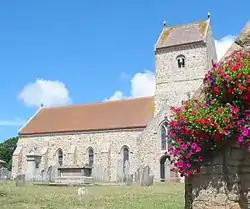 The Parish Church in St. Lawrence | |
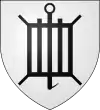 Coat of arms | |
 Location of Saint Lawrence in Jersey | |
| Crown Dependency | Jersey, Channel Islands |
| Government | |
| • Connétable | Deidre Mezbourian |
| Area | |
| • Total | 9.5 km2 (3.7 sq mi) |
| Area rank | Ranked 7th |
| Population (2011) | |
| • Total | 5,418[2] |
| Time zone | GMT |
| • Summer (DST) | UTC+01 |
| Postcode district | |
| Postcode sector | 1 |
| Website | www |
Much of the parish is inland, though it has a short stretch of coastline in St Aubin's Bay. It borders St Peter and St Mary to the west, St John to the north and east, and St Helier to the east.
History
The Jersey parish system has been in place for centuries. By Norman times, the parish boundaries were firmly fixed and remain largely unchanged since.[3]
In 1180 Jersey was divided by the Normans into three ministeria for administrative purposes. St Lawrence was part of de Groceio. De Groceio likely refers to the Jersey family name, de Gruchy.[3]
Governance
The parish is divided into vingtaines for administrative purposes:
- La Vingtaine Haut de la Vallée
- La Vingtaine Bas de la Vallée
- La Vingtaine du Coin Hatain
- La Vingtaine du Coin Motier
- La Vingtaine du Coin Tourgis Nord
- La Vingtaine du Coin Tourgis Sud
Including the Connétable, the parish has three elected representatives in the States of Jersey. As of 2011 the parish Deputies are Deputy John Le Fondré and Deputy Edward Noel.
All parishes of Jersey, including St Lawrence, have an Honorary Police force.
Geography
The parish is mainly rural, but has some significant residential development. The village is in the centre of the parish, forming around the A10 main road, however it does not have a lot of residential development. Most of the development in the parish is in the south of the parish around Le Mont Felard and Bel Royal or in the north of the parish at Six Roads.
The parish has a section of Victoria Avenue, the island's main dual carriageway.
Demographics
The parish has 5,418 residents according to the 2011 census.
| Year | Pop. | ±% |
|---|---|---|
| 1991 | 4,561 | — |
| 1996 | 4,773 | +4.6% |
| 2001 | 4,702 | −1.5% |
| 2011 | 5,418 | +15.2% |
Landmarks
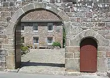
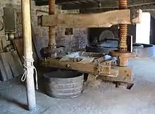
Hamptonne, the Country Life Museum, occupies restored farm buildings in the parish. An apple orchard preserves native Jersey cider apple varieties and the preinseu (cider press house) is the focus of the annual Faîs'sie d'cidre cidermaking festival using traditional equipment and methods. The ITV drama Under the Greenwood Tree was mostly filmed here.[4]
The Jersey War Tunnels (previously known as the German Underground Hospital) are a major relic of the engineering works undertaken by the occupying German forces 1940–1945. They also serve as a memorial to the many slave-workers pressed into labouring on such projects during the Second World War.
Education
There are two primary schools in the parish. Bel Royal school is in the south and St Lawrence School is in the north.
External links
Notes
- Measured from the Parish Hall to the Royal Square
References
- "Election results 2011". Gov.je. Retrieved 2012-10-05.
- "Jersey Census 2011" (PDF). Retrieved 2012-10-05.
- Syvret, Marguerite (2011). Balleine's History of Jersey. The History Press. ISBN 978-1860776502.
- "Jersey to host major film production". 4rfv.co.uk. 2005-05-23. Retrieved 2012-10-05.