Saint John, Jersey
St John (Jèrriais: Saint Jean) is one of the twelve parishes of Jersey and is around 7.3 kilometres (4.5 mi)[lower-alpha 1] north of St Helier on the north coast of the island. It has a surface area of 8.7 km2. St John's Village is also the name of the main village in the parish.
Saint John
Saint-Jean (French) | |
|---|---|
.jpg.webp) Village precinct | |
.svg.png.webp) Coat of arms | |
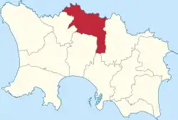 Location of Saint John in Jersey | |
| Crown Dependency | Jersey, Channel Islands |
| Government | |
| • Connétable | Chris Taylor |
| • Rector | Beverley Sproats |
| Area | |
| • Total | 8.7 km2 (3.4 sq mi) |
| Area rank | Ranked 9th |
| Population (2011) | |
| • Total | 2,911 |
| • Density | 330/km2 (870/sq mi) |
| Time zone | GMT |
| • Summer (DST) | UTC+01 |
| Postcode district | |
| Postcode sector | 4 |
| Website | www |
The parish is largely rural, with two main settlements: its namesake village and the village of Sion on the border with St Helier.
History
The church is dedicated to St John the Baptist and the symbol for St John has links to the Crusades - the Maltese cross is used within Jersey to depict the Parish of St John. The full name of the church is Saint-Jean des Chênes (St John of the Oaks).[2] The church is known to have existed as early as 1150.[2]
The Jersey parish system has been in place for centuries. By Norman times, the parish boundaries were firmly fixed and remain largely unchanged since.[3]
In 1180 Jersey was divided by the Normans into three ministeria for administrative purposes. St John was part of de Groceio. De Groceio likely refers to the Jersey family name, de Gruchy.[3]
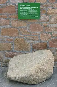
La Route du Nord was constructed during the German occupation of the Channel Islands as a scheme to provide work. The road is now dedicated to the men and women of Jersey who suffered 1939–1945.
Governance
.jpg.webp)
The parish is divided into vingtaines for administrative purposes as follows:
Boundary between Hérpue and Nord: Along the valley leaving from Handois Reservoir to the east west of La Rue Militaire. Along the south side of La Rue Militaire and La Route des Issues
Boundary between Nord and Douet: Along the east side of La Route du Nord, along the south side of La Route des Issues, along the west side of La Rue de la Mare Ballam.
The parish is one electoral district and elects one Deputy.
Geography
St. John shares borders with St Mary on its west, Trinity to the east, and St Lawrence and Saint Helier on its south.
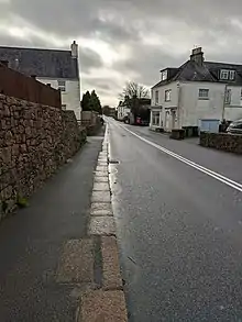
Largely a rural community, the namwsake has a small shopping precinct, and village pub, around its parish church, with the primary school and parish hall across the main road. There is also a supermarket and recreation centre to the east of the village.[4]
There is also a second village of Sion in the Southwestern panhandle of the parish. This is quite a small village centred around the main road. It has a small shop and a garage.
The cliffs of the north coast afford some of the best views in Jersey. After Trinity, it has the second highest point in Jersey at Mont Mado (473 ft). The parish covers territory of 4,846 vergées (8.7 km2.).
There is a single usable beach in the parish at the Bonne Nuit harbour, accessible by a hilly windy road that connects to the village.
Mont Mado granite was quarried historically. The largest quarry is now that of Ronez on the north coast.[5]
Demographics
Saint John is the second least populated parish of Jersey, having only 2,911 residents as of 2011.[6]
| Year | Pop. | ±% |
|---|---|---|
| 1991 | 2,440 | — |
| 1996 | 2,520 | +3.3% |
| 2001 | 2,618 | +3.9% |
| 2011 | 2,911 | +11.2% |
Transport
The main road for the parish is the A9, which runs from the parish church and connects the main settlements (Hautes Croix and Sion) of the parish before running along a lightly developed road to the town. It connects all the way to the waterfront. Other main link roads include the A8 which runs to Trinity, the B33 which continues on from the A9 and runs eastward to St Mary and the A10 which starts in the south of the village and runs down towards St Lawrence. The parish is served by three bus routes that connect the parish to St Mary, St Lawrence, Trinity and St Helier.
Gallery
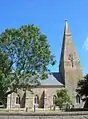 Parish church
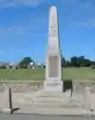 War memorial
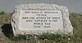 La Route du Nord dedication stone
Notes
- Measured from the Parish Hall to the Royal Square
References
- "Members". Statesassembly.gov.je. Retrieved 2012-10-04.
- "Parish church St John - theislandwiki". www.theislandwiki.org. Retrieved 2020-12-30.
- Syvret, Marguerite (2011). Balleine's History of Jersey. The History Press. ISBN 978-1860776502.
- "BBC News - Jersey parish hall completed but comes in over budget". Bbc.co.uk. 2010-08-28. Retrieved 2012-10-04.
- "Threat to 30 jobs at Ronez « This Is Jersey". Thisisjersey.com. 2008-10-03. Retrieved 2012-10-04.
- http://www.gov.je/Government/Census/Census2011/Pages/2011CensusResults.aspx