Saint Peter, Jersey
St Peter (French: Saint-Pièrre; Jèrriais: St Pièrre) is one of the twelve parishes of Jersey in the Channel Islands. It is around 6.5 kilometres (4.0 mi).[lower-alpha 1] The parish has a population of 5,003. It has a surface area of 10.6 square kilometres (4.1 sq mi).
Saint Peter
| |
|---|---|
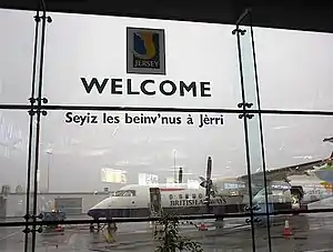 Welcome to Jersey sign at Jersey Airport | |
.svg.png.webp) Coat of arms | |
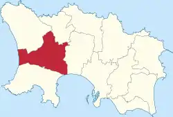 Location of Saint Peter in Jersey | |
| Crown Dependency | Jersey, Channel Islands |
| Government | |
| • Connétable | John Refault |
| Area | |
| • Total | 11.6 km2 (4.5 sq mi) |
| Area rank | Ranked 4th |
| Elevation | 84 m (276 ft) |
| Population (2011) | |
| • Total | 5,003 |
| • Density | 430/km2 (1,100/sq mi) |
| Time zone | GMT |
| • Summer (DST) | UTC+01 |
| Postcode district | |
| Postcode sector | 7 |
It is the only parish with two separate coastlines, stretching from St Ouen's Bay in the west to St Aubin's Bay in the south, and thereby cutting St Brelade off from other parishes. It also borders St Ouen and St Mary to the north and St Lawrence to the east. A large portion of the parish is occupied by Jersey Airport.
The traditional nickname for St. Pierrais is ventres à baînis (limpet bellies), perhaps because their parish sticks to two coasts like limpets.
History
The Jersey parish system has been in place for centuries. By Norman times, the parish boundaries were firmly fixed and remain largely unchanged since.[3]
The parish church was built by at least 1053. There are two bells called Elizabeth and Mary, dated to 1649 and 1754 respectively. There is an ancient unique custom in the parish to ring out the bells continuously on Christmas Eve and Christmas Day. It is dedicated to St Peter in the desert.[4]
In 1180 Jersey was divided by the Normans into three ministeria for admistrative purposes. St Peter was part of Crapoudoit. Crapoudoit likely refers to the stream running through St Peter's Valley.[3]
Governance
The parish is divided into vingtaines for administrative purposes as follows:
- La Vingtaine du Douet
- La Vingtaine de St. Nicolas
- La Grande Vingtaine
- La Vingtaine des Augerez
- La Vingtaine du Coin Varin
The parish forms one electoral district and elects one Deputy.
Demography
| Year | Pop. | ±% |
|---|---|---|
| 1991 | 4,231 | — |
| 1996 | 4,228 | −0.1% |
| 2001 | 4,293 | +1.5% |
| 2011 | 5,003 | +16.5% |
Education
St. Peter's School is located in La Rue du Presbytère, and is a state run primary school with 164 students in 2009.[5] The fee-charging St. George's Preparatory School is located at La Hague Manor, Rue de la Hague, which is wholly owned by The Jersey Educational Trust.[6]
Notable residents
- Gilbert O'Sullivan resides in Saint Peter with his wife Aase and their two children.
- Caroline LeSueur, a Mormon pioneer and one of the founders of St. Johns, Arizona.
- Augustus Asplet Le Gros, a Norman language poet and a Jurat of the Royal Court of Jersey.
- George William de Carteret, a Norman language journalist and writer
- Peter Vincenti, footballer
Notes
- Measured from the Parish Hall to the Royal Square
References
- "Election results 2011". Gov.je. Retrieved 2012-10-05.
- Syvret, Marguerite (2011). Balleine's History of Jersey. The History Press. ISBN 978-1860776502.
- "St Peters church | Our Church". www.stpeterschurch.org.je. Retrieved 2021-01-11.
- St. Peter's School Archived 2006-07-01 at the Wayback Machine
- St. George's Preparatory