Saint Saviour, Jersey
St. Saviour (Jèrriais: St Saûveux; French: Saint-Sauveur) is a parish of Jersey in the Channel Islands. It is located directly east of St. Helier. It has a population of 13,580.[2] It has a land surface area of 3.6 square miles (9.3 km2) and has a very small coastline at Le Dicq.
Saint Saviour
| |
|---|---|
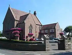 Parish Hall of Saint Saviour | |
.svg.png.webp) Coat of arms | |
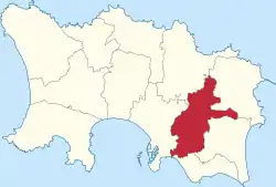 Location of Saint Saviour Saint-Sauveur Saint Saûveux in Jersey | |
| Crown Dependency | Jersey, Channel Islands |
| Government | |
| • Connétable | Sadie Sueur-Rennard |
| Area | |
| • Total | 9.3 km2 (3.6 sq mi) |
| Area rank | Ranked 8th |
| Population (2011) | |
| • Total | 13,580 |
| • Density | 1,500/km2 (3,800/sq mi) |
| Time zone | GMT |
| • Summer (DST) | UTC+01 |
| Postcode district | |
| Postcode sector | 7 |
The parish is quite urbanised, hosting the suburbs and exurbs for the town of St. Helier. The most notable settlement is located around the Five Oaks area in the centre of the parish and Georgetown in the South. The village of Maufant is located on the boundary with St. Martin.
History
The parish's name derives from Jesus Christ as the Redeemer (Sanctus Salvator). The parish church's full dedication is to St Saviour of the Thorn.
The parish crest displays a thorn with three nails, to represent the Saviour's suffering.
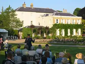
Government House is the official residence of the Lieutenant-Governor, the Queen's representative in Jersey. It was originally known as Belmont and was acquired in 1821. It was originally constructed in 1814.[3]
The parish church existed at least as early as 1087. Within its precincts, when plague was raging in 1563, the Royal Court of Jersey found a refuge, by permission granted of Hugh Perrin, on whose fief the building stood.[4] Extensive repairs took place on the church in the late 19th and early 20th centuries.
The church and parish hall are located half way along the road known as St Saviour's Hill. In the 19th Century the road was opened on its current route. Before then, the road ran through the current grounds of Government House. There was formerly an inn in what is now part of the cemetery of the church.[5]
Governance
The parish is divided into vingtaines for administrative purposes as follows:
- La Vingtaine de Maufant
- La Vingtaine de Sous la Hougue
- La Vingtaine des Pigneaux
- La Vingtaine de la Grande Longueville
- La Vingtaine de la Petite Longueville
- La Vingtaine de Sous l'Église
For electoral purposes the parish is divided into three districts:
- District No. 1 (Vingtaine de la Petite Longueville) elects two Deputies
- District No. 2 (Vingtaine de Sous l'Église) elects two Deputies
- District No. 3 (Vingtaines de Maufant, de Sous la Hougue, des Pigneaux and de la Grande Longueville) elects one Deputy
The present States Members representing St Saviour are:
- Connétable Sadie Le Sueur-Rennard
- Deputy Jeremy Maçon (No. 1)
- Deputy Kevin Pamplin (No. 1)
- Deputy Kevin Lewis (No. 2)
- Deputy Louise Doublet (No. 2)
- Deputy Jess Perchard (No. 3)
Under the proposed electoral reform, St Saviour would elect five representatives on a parish-wide basis, rather in three districts.
Geography
St Saviour is in the east of the island of Jersey. It borders Trinity, St Martin, Grouville, St Clement and St Helier.
The south of the parish is a highly urbanised part of town, focused around Georgetown and Five Oaks. The area in the south is known as Georgetown, Plat Douet and Longueville. It is near Howard Davis Park and has a short piece of coastline, the only one in the parish. It is also home to the Rue des Près Trading Estate. The Five Oaks area is home to many schools and suburban housing for St Helier.
The remainder of the parish is largely rural, save for a few small developments such as Maufant Village (split between St Saviour and St Martin) and the houses near Queen's Valley Reservoir. The Grands Vaux reservoir runs along the border of St Saviour and St Helier.
In terms of transport, the parish has many main roads that run through the parish to connect to other parishes, such as La Grande Route de Saint-Martin and Longueville Road. Part of the St Helier Ring Road is located within St Saviour.
The parish does not have any green lanes. The parish's Connétable Sadie Le Sueur-Rennard said 'I can’t see where we would have a green lane',[6] although the parish has a large number of lanes (including lanes that border green lanes in St Martin).
Demography
Saint Saviour is Jersey's second most populated parish, with 13,580 residents in 2011.
| Year | Pop. | ±% |
|---|---|---|
| 1991 | 12,747 | — |
| 1996 | 12,680 | −0.5% |
| 2001 | 12,491 | −1.5% |
| 2011 | 13,580 | +8.7% |
Landmarks
- Government House
- Grainville Cricket Ground
- St Saviour's Church
- Rue des Près Trading Estate
- Highalnds College Turner Building
- College House (Jersey College for Girls)
- Longueville Manor
Education
The parish is home to a very large number of schools. Many of the schools have an island-wide student body, and therefore during school pick-up and drop-off times the roads in the parish can become very congested.
- Highlands College
- De La Salle College
- De La Sallle Primary School
- St. Michael's Preparatory School
- Jersey College for Girls
- Jersey College Preparatory School
- Hautlieu School
- Grainville School*
- FCJ Primary School
- Plat Douet School*
- St Luke's School*
- St Saviour's School*
- D'Hautree School
*Government-maintained catchment schools
Notable residents
- Lillie Langtry (1853)
- Agnes Harben (died 1961), British suffragist
See also
Gallery
 Longueville in St Saviour
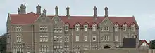 College House, formerly the boarding house of Victoria College
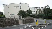 JCG is a government-maintained fee-paying selective school located in the parish
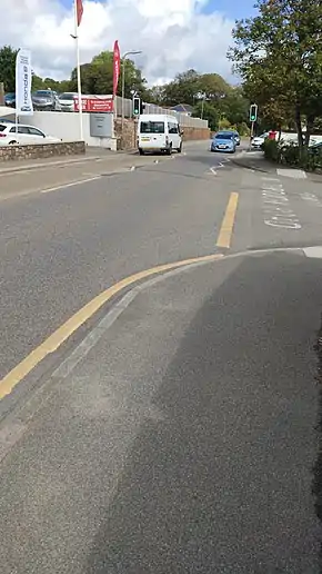
 Boundary stone between St Saviour and St Helier on La Rue Le Masurier
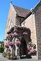 St Saviour's Parish Hall
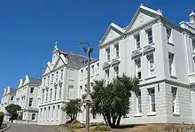 Highlands College in St Saviour
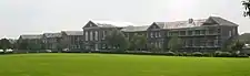 St Saviour's Hospital in St Saviour
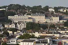 The Hotel de France on St Saviour's Road
References
- "BBC News - Sadie Rennard wins Jersey constable vote in St Saviour". Bbc.co.uk. 2011-10-19. Retrieved 2012-10-05.
- Jersey, States of. "Government of Jersey". gov.je. Retrieved 2020-12-11.
- "Government House - theislandwiki". www.theislandwiki.org. Retrieved 2020-12-11.
- "St Saviour Parish Church - theislandwiki". www.theislandwiki.org. Retrieved 2020-12-11.
- "A history of St Saviour's Church and the surrounding area - theislandwiki". www.theislandwiki.org. Retrieved 2020-12-11.
- "All parishes 'need to join the Island's green lane network'". jerseyeveningpost.com. Retrieved 2021-01-24.