Shahjahanpur
Shahjahanpur (/ʃɑːdʒəˌhɑːnˈpʊər/) is a municipal corporation, town and district headquarters of Shahjahanpur District in Uttar Pradesh, India.
Shahjahanpur
Sahejapur Shaheedon Ki Nagri | |
|---|---|
City | |
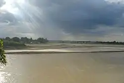 River Garrah flowing through Shahjahanpur | |
 Shahjahanpur | |
| Coordinates: 27.88°N 79.91°E | |
| Country | India |
| State | Uttar Pradesh |
| District | Shahjahanpur |
| Named for | Shah Jahan |
| Government | |
| • Body | Nagar Nigam |
| Area | |
| • Total | 51 km2 (20 sq mi) |
| Elevation | 194 m (636 ft) |
| Population (2011) | |
| • Total | 346,103 |
| • Density | 6,800/km2 (18,000/sq mi) |
| Time zone | UTC+5:30 (IST) |
| PIN | 242001 |
| Telephone code | 05842 |
| Vehicle registration | UP-27 |
| Sex ratio | 880 ♀/ 1000 ♂ |
| Literacy | |
| Website | shahjahanpur |
The city is nestled between Bareilly and Lucknow, the capital of Uttar Pradesh.
The city is the home for prestigious industries like Kribhco fertilizers limited, Roza thermal power plant, Ordnance Clothing Factory, Shahjahanpur.
History
Shahjahanpur was established by Dilir Khan and Bahadur Khan, sons of Dariya Khan, a soldier in army of the Mughal emperor Jahangir. Dariya Khan was originally from Kandahar, in modern-day Afghanistan.[1] Both Dilir Khan and Bahadur Khan were dignitaries in the regime of Shah Jahan. Pleased with the services of Dilir Khan, Shah Jahan gave him 17 villages with the permission to construct a fort in 1647, following the suppression of the rebellious Katheria Rajputs.[2]
On 9 August 1925, the Indian freedom fighters Ram Prasad Bismil, Ashfaqulla Khan, Chandrashekhar Azad and Rajendra Lahiri conducted a robbery of government funds near Kakori railway station. Both Bismil and Khan were born in Shahjahanpur.[3]
Geography
Shahjahanpur is located at 27.88°N 79.91°E. It has an average elevation of 194 metres (600 feet). It is situated at the junction of two river.
Climate
| Climate data for Shahjahanpur (1981–2010, extremes 1977–2012) | |||||||||||||
|---|---|---|---|---|---|---|---|---|---|---|---|---|---|
| Month | Jan | Feb | Mar | Apr | May | Jun | Jul | Aug | Sep | Oct | Nov | Dec | Year |
| Record high °C (°F) | 28.3 (82.9) |
32.8 (91.0) |
38.8 (101.8) |
43.4 (110.1) |
45.0 (113.0) |
46.2 (115.2) |
43.2 (109.8) |
39.5 (103.1) |
37.5 (99.5) |
37.4 (99.3) |
33.5 (92.3) |
28.7 (83.7) |
46.2 (115.2) |
| Average high °C (°F) | 20.3 (68.5) |
24.1 (75.4) |
29.7 (85.5) |
36.2 (97.2) |
38.2 (100.8) |
37.3 (99.1) |
33.4 (92.1) |
32.7 (90.9) |
32.2 (90.0) |
31.6 (88.9) |
28.0 (82.4) |
22.9 (73.2) |
30.6 (87.1) |
| Average low °C (°F) | 7.1 (44.8) |
9.9 (49.8) |
14.1 (57.4) |
19.5 (67.1) |
23.9 (75.0) |
25.8 (78.4) |
25.7 (78.3) |
25.4 (77.7) |
23.8 (74.8) |
18.0 (64.4) |
11.8 (53.2) |
8.0 (46.4) |
17.7 (63.9) |
| Record low °C (°F) | 0.6 (33.1) |
2.6 (36.7) |
6.0 (42.8) |
8.4 (47.1) |
15.6 (60.1) |
17.0 (62.6) |
20.1 (68.2) |
20.0 (68.0) |
15.0 (59.0) |
8.4 (47.1) |
5.0 (41.0) |
1.2 (34.2) |
0.6 (33.1) |
| Average rainfall mm (inches) | 14.6 (0.57) |
21.6 (0.85) |
9.8 (0.39) |
11.6 (0.46) |
30.2 (1.19) |
133.1 (5.24) |
289.3 (11.39) |
239.9 (9.44) |
198.0 (7.80) |
38.2 (1.50) |
2.7 (0.11) |
10.9 (0.43) |
999.9 (39.37) |
| Average rainy days | 1.1 | 1.6 | 1.1 | 1.2 | 1.9 | 5.2 | 11.0 | 11.3 | 8.0 | 1.3 | 0.3 | 0.8 | 44.9 |
| Average relative humidity (%) (at 17:30 IST) | 70 | 56 | 46 | 30 | 33 | 48 | 72 | 77 | 75 | 64 | 65 | 70 | 59 |
| Source: India Meteorological Department[4][5] | |||||||||||||
Demographics
As per provisional data of 2011 census, Shahjahanpur urban agglomeration had a population of 346,103, out of which males were 183,087 and females were 163,016. The literacy rate was 69.81 per cent.[6]
Cultural heritage
Over the years, the Shahjahanpur gharana contributed eminent sarod players such as Enayat Ali (1883 - 1915), Ustad Murad Ali Khan, Ustad Mohammed Ameer Khan, Pandit Radhika Mohan Moitra and Pandit Buddhadev Das Gupta.[7][8][9] Present Sarod legend, Amjad Ali Khan also belongs to Shahjahanpur gharana.[10]
Notable people
- Ram Prasad Bismil (Freedom Fighter)
- Ashfaqulla Khan (Freedom Fighter)
- Roshan Singh (Freedom Fighter)
- Prem Krishna Khanna (Freedom Fighter)
- Jitendra Prasada (Former M.P.)
- Naik Jadu Nath Singh (Param Vir Chakra) in
- Rajpal Yadav (Film Actor)
- Alok Pandey (Film Actor)
- Jitin Prasada (Former Central Government Cabinet Minister)
- Mithlesh Kumar (Former member of parliament)
- Krishna Raj (Former MP)
- Suresh Kumar Khanna (UP Government Cabinet Minister)
- Rammurti Singh Verma (Former Minister of UP)
- Roshan Lal Verma (MLA Tilhar)
- Sharad Vir Singh (MLA Jalalabad)
- Tanveer Khan (Former Chairman)
- Pallavi Gupta (Rajmata W3Villa)
- Abu Salman Shahjahanpuri (Pakistani scholar)
Education
- State medical college shahjahanpur(http://www.smcshah.in)
- varun arjun medical college shahjahanpur(https://www.vamcrh.com/)
References
- Dr. Mehrotra N.C. Shahjahanpur Etihasik Evam Sanskritik Dharohar 1999 Pratiman Prakashan 30 Kucha Ray Ganga Prasad Allahabad 211003 India page 114
- Joshi, Rita (1985). The Afghan Nobility and the Mughals 1526-1707. New Delhi: Vikas Pub. House. p. 153. ISBN 9780706927528.
- Chandra, Bipan (14 October 2000). India's Struggle for Independence. Penguin Books Limited. p. 302. ISBN 978-81-8475-183-3. Retrieved 24 June 2013.
- "Station: Shahajahanpur Climatological Table 1981–2010" (PDF). Climatological Normals 1981–2010. India Meteorological Department. January 2015. pp. 693–694. Archived from the original (PDF) on 5 February 2020. Retrieved 22 September 2020.
- "Extremes of Temperature & Rainfall for Indian Stations (Up to 2012)" (PDF). India Meteorological Department. December 2016. p. M223. Archived from the original (PDF) on 5 February 2020. Retrieved 22 September 2020.
- "Urban Agglomerations/Cities having population 1 lakh and above" (PDF). Provisional Population Totals, Census of India 2011. Retrieved 7 July 2012.
- Chakraverty, Soumya. "History of the Gharana". Retrieved 8 February 2015.
- Miner, Allyn (1 January 1997). Sitar and Sarod in the 18th and 19th Centuries. Motilal Banarsidass. p. 140. Retrieved 8 February 2015.
- "Gharana". Retrieved 8 February 2015.
- "Gharana". Retrieved 25 December 2017.
- "Gandhi Faiz-E-Aam College, Shahjahanpur". gfcollege.in.
- "Swami Shukdevanand Postgraduate College". sscollegespn.org.