Ab Khuda'i
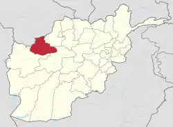
Ab Khuda'i or Abzi Khuda'i[2] is a village in the west of Ab Kamari District in Herat Province, of north-west Afghanistan. Its population, consists of approximately 90% Tajik with a small Pashtun, Aimaq and Uzbek minority. Other localities include Alkhan, Anjir, Duzdanak, Gana Gul, Khalifa, and Papal. The village used to be in Badghis Province.[3]
Ab Khuda'i | |
|---|---|
Village | |
 Ab Khuda'i Location of Ab Khuda'i in Afghanistan | |
| Coordinates: 34.9°N 62.7°E[1] | |
| Country | Afghanistan |
| Province | Herat |
| District | Kushki Kohna |
| Time zone | UTC+4:30 (Afghanistan Standard Time) |
References
- "Afg: Badghis Province - Reference Map | HumanitarianResponse". www.humanitarianresponse.info. Retrieved 6 September 2020.
- Latitude.to. "GPS coordinates of Ab Khuda'i, Afghanistan. Latitude: 35.2710 Longitude: 63.6830". Latitude.to, maps, geolocated articles, latitude longitude coordinate conversion. Retrieved 8 October 2020.
- "Baghdis Province Land Cover Map" (PDF). ucdavis.edu. AIMS. 2002.
This article is issued from Wikipedia. The text is licensed under Creative Commons - Attribution - Sharealike. Additional terms may apply for the media files.