Alliat
Alliat is a commune in the Ariège department and Occitanie region in southwestern France.
Alliat | |
|---|---|
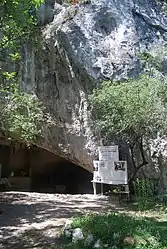 The entrance to the La Vache Cave | |
Location of Alliat 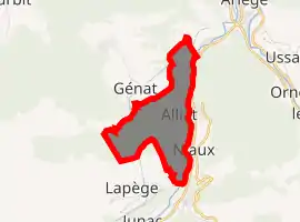
| |
 Alliat  Alliat | |
| Coordinates: 42°49′05″N 1°35′14″E | |
| Country | France |
| Region | Occitanie |
| Department | Ariège |
| Arrondissement | Foix |
| Canton | Sabarthès |
| Intercommunality | Pays de Tarascon |
| Government | |
| • Mayor (2020–2026) | Marie-Françoise Kalandadze |
| Area 1 | 3.46 km2 (1.34 sq mi) |
| Population (2017-01-01)[1] | 51 |
| • Density | 15/km2 (38/sq mi) |
| Time zone | UTC+01:00 (CET) |
| • Summer (DST) | UTC+02:00 (CEST) |
| INSEE/Postal code | 09006 /09400 |
| Elevation | 500–1,268 m (1,640–4,160 ft) (avg. 560 m or 1,840 ft) |
| 1 French Land Register data, which excludes lakes, ponds, glaciers > 1 km2 (0.386 sq mi or 247 acres) and river estuaries. | |
Geography
Commune in the "Haute-Ariège" part of the Pyrenees located 15 km from the city of Foix and 5 km from the city of Tarascon-sur-Ariège, in the "Parc naturel régional des Pyrénées ariégeoises".
Population
Inhabitants of Alliat are called Alliatois.
| Year | Pop. | ±% |
|---|---|---|
| 2005 | 65 | — |
| 2006 | 66 | +1.5% |
| 2007 | 66 | +0.0% |
| 2008 | 64 | −3.0% |
| 2009 | 63 | −1.6% |
| 2010 | 61 | −3.2% |
| 2011 | 59 | −3.3% |
| 2012 | 58 | −1.7% |
| 2013 | 57 | −1.7% |
| 2014 | 55 | −3.5% |
| 2015 | 54 | −1.8% |
| 2016 | 53 | −1.9% |
Sights
- The "cave of the cow" (grotte de La Vache): with distinctive archeological strata discovered in its entrance and in the "salle Monique", opened to the public in 1979. It produced a remarkably rich collection of prehistorical objects from the Magdalenian era (12,000 to 14,000 years old), including a large number of harpoons and assegai points as well as more than 200 pieces of art: bones, engraved reindeer and red deer antlers, sculpture of animals, sometimes of humans, as well as rare species for that period: panther, bear, wolves, Saiga antelope, birds and salmon.
- It was one of the first caves explored in Ariège (Félix Garrigou, in 1866). A second salle was discovered in 1952 and was explored by its discoverer, Romain Robert, until 1964.
- Fortified cave Spoulgas d’Alliat: located 100 m south of the cave of the cow.[2]
Activities
- Rock climbing around the caves
- Horse ridding
See also
References
- "Populations légales 2017". INSEE. Retrieved 6 January 2020.
- Maps and descriptions available in "Monographies villageoises en Sabarthès", Florence Guillot, 1999.
| Wikimedia Commons has media related to Alliat. |
| Authority control |
|
|---|
This article is issued from Wikipedia. The text is licensed under Creative Commons - Attribution - Sharealike. Additional terms may apply for the media files.