Arabaux
Arabaux is a commune in the Ariège department in the Occitanie region of southwestern France.
Arabaux | |
|---|---|
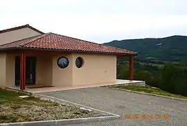 Arabaux Community Hall | |
Location of Arabaux 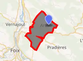
| |
 Arabaux  Arabaux | |
| Coordinates: 42°59′09″N 1°38′37″E | |
| Country | France |
| Region | Occitanie |
| Department | Ariège |
| Arrondissement | Foix |
| Canton | Val d'Ariège |
| Intercommunality | Pays de Foix |
| Government | |
| • Mayor (2020–2026) | Jean-Claude Dupuy |
| Area 1 | 4.59 km2 (1.77 sq mi) |
| Population (2017-01-01)[1] | 76 |
| • Density | 17/km2 (43/sq mi) |
| Time zone | UTC+01:00 (CET) |
| • Summer (DST) | UTC+02:00 (CEST) |
| INSEE/Postal code | 09013 /09000 |
| Elevation | 395–826 m (1,296–2,710 ft) (avg. 500 m or 1,600 ft) |
| 1 French Land Register data, which excludes lakes, ponds, glaciers > 1 km2 (0.386 sq mi or 247 acres) and river estuaries. | |
The inhabitants of the commune are known as Arabausois or Arabausoises[2]
Geography
Arabaux is some 20 km south of Pamiers and 2 km north-east of Foix to which urban area it belongs. National Highway N20 passes through the south-western corner of the commune partly in a tunnel but it has no exit in the commune with the nearest exit No. 10 south of Saint-Jean-de-Verges. The D1 road goes from Foix through the south of the commune and continues east to Carla-de-Roquefort. Access to the village is by country roads - one from the NR20 Exit 10 and one from the D1 on the eastern border. The commune is heavily forested in the centre and west with the rest of the land farmland.[3]
The Alses river passes through the centre of the commune from east to west then turns north forming part of the western border to join the Ariège near the NR20 Exit 10. The Ruisseau d'Araboux rises west of the village and flows north-west to join the Ariege.[3]
History
Bernard de Lordat, co-lord of Lordat, received Arabaux in around 1250, after an exchange with the count of Foix and thus became the lord.
Administration
List of Successive Mayors[4]
| From | To | Name | Party | Position |
|---|---|---|---|---|
| 1804 | 1808 | Jean Duran | ||
| 1810 | 1812 | Dominique Rouch | ||
| 1813 | 1813 | Pierre Rouch | ||
| 1816 | 1819 | François Azam Coustant | ||
| 1823 | 1828 | Dominique Rouch | ||
| 1853 | 1853 | Pierre Rouch | ||
| 1877 | 1878 | Jean Melet | ||
| 1884 | 1892 | Jean-Baptiste Marfaing | ||
| 2001 | 2020 | Michel Rouch |
(Not all data is known)
Demography
In 2017 the commune had 76 inhabitants.
|
| ||||||||||||||||||||||||||||||||||||||||||||||||||||||||||||||||||||||||||||||||||||||||||||||||||||||||||||||||||
| Source: EHESS[5] and INSEE[6] | |||||||||||||||||||||||||||||||||||||||||||||||||||||||||||||||||||||||||||||||||||||||||||||||||||||||||||||||||||
See also
External links
- Arabaux on the National Geographic Institute website (in French)
- Arabaux on Lion1906
- Arabaux on Géoportail, National Geographic Institute (IGN) website (in French)
- Arabaux on the 1750 Cassini Map
Notes and references
Notes
References
- "Populations légales 2017". INSEE. Retrieved 6 January 2020.
- Inhabitants of Ariège (in French)
- Google Maps
- List of Mayors of France
- Des villages de Cassini aux communes d'aujourd'hui: Commune data sheet Arabaux, EHESS. (in French)
- Population en historique depuis 1968, INSEE
| Wikimedia Commons has media related to Arabaux. |
