Arignac
Arignac is a commune in the Ariège department in the Occitanie region of south-western France.
Arignac | |
|---|---|
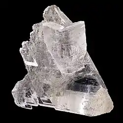 Gypsum from Arignac | |
Location of Arignac 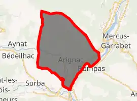
| |
 Arignac  Arignac | |
| Coordinates: 42°52′19″N 1°36′05″E | |
| Country | France |
| Region | Occitanie |
| Department | Ariège |
| Arrondissement | Foix |
| Canton | Sabarthès |
| Intercommunality | CC Pays Tarascon |
| Government | |
| • Mayor (2014-2020) | Philippe Pujol |
| Area 1 | 8.84 km2 (3.41 sq mi) |
| Population (2017-01-01)[1] | 707 |
| • Density | 80/km2 (210/sq mi) |
| Time zone | UTC+01:00 (CET) |
| • Summer (DST) | UTC+02:00 (CEST) |
| INSEE/Postal code | 09015 /09400 |
| Elevation | 467–1,371 m (1,532–4,498 ft) (avg. 470 m or 1,540 ft) |
| 1 French Land Register data, which excludes lakes, ponds, glaciers > 1 km2 (0.386 sq mi or 247 acres) and river estuaries. | |
The inhabitants of the commune are known as Arignacois or Arignacoises[2]
Geography
Arignac is located 2 km north of Tarascon-sur-Ariège and some 11 km south of Foix. Access to the commune is by road D88 from Tarascon-sur-Ariège in the south passing through the village and continuing north-east to join National Highway N20 at Exit 14. The N20 passes through the south-east of the commune but the nearest exit is Exit 14 just east of the commune. The town covers about 10% of the commune with the rest mostly forest and hill country with a few farms in the south.[3]
The Ariège river forms the south-eastern border of the commune and the Saurat flows south through the commune and the town to join the Ariège.[3]
Neighbouring communes and villages
Places adjacent to Arignac | |
|---|---|
Administration
List of successive mayors[4]
| From | To | Name | Party | Position |
|---|---|---|---|---|
| 1900 | 1919 | Louis Philippe | ||
| 2001 | 2020 | Philippe Pujol |
(Not all data is known)
Demography
In 2017, the commune had 707 inhabitants.[5]
|
| ||||||||||||||||||||||||||||||||||||||||||||||||||||||||||||||||||||||||||||||||||||||||||||||||||||||||||||||||||
| Source: EHESS[6] and INSEE[5] | |||||||||||||||||||||||||||||||||||||||||||||||||||||||||||||||||||||||||||||||||||||||||||||||||||||||||||||||||||
See also
References
- "Populations légales 2017". INSEE. Retrieved 6 January 2020.
- Inhabitants of Ariège (in French)
- Google Maps
- List of Mayors of France (in French)
- Population en historique depuis 1968, INSEE
- Données Cassini, EHESS
External links
- Arignac on Lion1906
- Arignac on Géoportail, National Geographic Institute (IGN) website (in French)
- Arignac on the 1750 Cassini Map