Aigues-Vives, Ariège
Aigues-Vives (French pronunciation: [ɛɡviv]) is a commune in the Ariège department in the Occitanie region of southwestern France.
Aigues-Vives | |
|---|---|
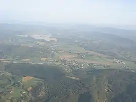 View of Aigues-Vives, Léran and the Lac de Montbel | |
.svg.png.webp) Coat of arms | |
Location of Aigues-Vives 
| |
 Aigues-Vives  Aigues-Vives | |
| Coordinates: 42°59′51″N 1°52′35″E | |
| Country | France |
| Region | Occitanie |
| Department | Ariège |
| Arrondissement | Pamiers |
| Canton | Mirepoix |
| Intercommunality | Pays de Mirepoix |
| Government | |
| • Mayor (2014-2020) | Christian Mascarenc |
| Area 1 | 5.16 km2 (1.99 sq mi) |
| Population | 666 |
| • Density | 130/km2 (330/sq mi) |
| Time zone | UTC+01:00 (CET) |
| • Summer (DST) | UTC+02:00 (CEST) |
| INSEE/Postal code | 09002 /09600 |
| Elevation | 391–621 m (1,283–2,037 ft) (avg. 410 m or 1,350 ft) |
| 1 French Land Register data, which excludes lakes, ponds, glaciers > 1 km2 (0.386 sq mi or 247 acres) and river estuaries. | |
The inhabitants of the commune are known as Aigues-Vivesiens or Aigues-Vivesiennes.[2][3]
Geography
Location
Aigues-Vives is located both in the Pays d'Olmes and the Canton of Mirepoix on the D625 main road (formerly Route nationale N625) which runs from Saint-Quentin-la-Tour in the north through the heart of the commune and the town to Laroque-d'Olmes in the south. It is about 90 km in a direct line south by south west of Narbonne. Augues-Vives can also be accessed from the east on Highway D28 from Léran. Apart from the Aigues-Vives town there is one other residential area to the north of the town called Le Kartare. The commune is forested to the west and the east with the centre of the commune farmland (apart from the town).[4]
Neighboring communes and villages
Places adjacent to Aigues-Vives, Ariège | ||||||||||
|---|---|---|---|---|---|---|---|---|---|---|
| ||||||||||
Hydrography
The Countirou stream, which has its source in the nearby village of Tabre, passes through the commune of Aigues-Vives, along the D625 road, and comes to an end at Hers-Vif near Mirepoix. A number of streams traverse the commune and flow into Coutirou including the: Fontaine de Toustou, the Couxou, the Ribalerie, and the Saint-Paul).[5]
Lake Montbel is located three kilometres south-east of the commune and is visible from the hills above Aigues-Vives.
Geology and terrain
The village is located in an area formed during the Tertiary period with a soil which is a mix of conglomerate and sandstone,[6] on strata called the "conglomerates of Palassou" located on the North Pyrenees faultline.[7]
Aigues-Vives is surrounded by several hills, the highest being 630m above sea level, on the western edge of the commune. The village itself is 420m high on average with the lowest point being 391m.[5]
Seismicity and disasters
According to decree No. 2010-1255 of 22 October 2010 on the delimitation of the seismicity of the French territory, Aigues-Vives is exposed to a risk level of 3 (moderate).[8]
Other risks facing Aigues-Vives are forest fires, industrial hazards, and risks due to transport of dangerous goods.[9] Past disasters include the November 1982 storm, flooding and mudslides in January 1992 and mudslides in November–December 1996.[10]
History
The first written mention of Aigues-Vives dates to 1301.[12] The village was under the control of Mirepoix, ten miles to the north, until 1329, when Gaston de Lévis-Léran appropriated the castle and the surrounding lands. The village remained in the possession of the Lévis-Léran family until the Revolution.[3]
The main industries in the 20th century were the making of "horn combs"[13] and textiles, as is the case for much of the Pays d'Olmes.[3]
Heraldry
Arms of Aigues-Vives |
Blazon: Or, paly of 2 vert and in chief the same. |
Policy and administration
Population and society
Population
| Year | Pop. | ±% |
|---|---|---|
| 2006 | 515 | — |
| 2007 | 523 | +1.6% |
| 2008 | 541 | +3.4% |
| 2009 | 559 | +3.3% |
| 2010 | 577 | +3.2% |
| 2011 | 591 | +2.4% |
| 2012 | 598 | +1.2% |
| 2013 | 615 | +2.8% |
| 2014 | 632 | +2.8% |
| 2015 | 649 | +2.7% |
| 2016 | 654 | +0.8% |
Pyramid of ages
The population of the town is relatively young.
Percentage Distribution of Age Groups in Aigues-Vives and Ariege Department in 2017
| Aigues-Vives | Ariège | |||
|---|---|---|---|---|
| Age Range | Men | Women | Men | Women |
| 0 to 14 Years | 17.5 | 20.5 | 16.6 | 15.0 |
| 15 to 29 Years | 13.4 | 10.7 | 14.8 | 12.5 |
| 30 to 44 Years | 14.4 | 17.3 | 16.6 | 16.6 |
| 45 to 59 Years | 26.7 | 26.4 | 21.4 | 21.0 |
| 60 to 74 Years | 21.7 | 19.1 | 20.2 | 19.9 |
| 75 to 89 Years | 6.0 | 5.7 | 9.3 | 12.4 |
| 90 Years+ | 0.3 | 0.3 | 1.0 | 2.6 |
Education
Aigues-Vives has a kindergarten and primary school, with 68 students (for the academic year 2010-2011).[18]
Sports
Several sports facilities exist in Aigues-Vives: a football club, a gymnasium, a Tai-chi group, a bicycle club, and a leisure centre which has a go-karting track and a mini-golf area.[12]
Health
There is no pharmacy or doctor in Aigues-Vives with the closest being at Laroque-d'Olmes about 3 kilometres away. The nearest hospital is in Lavelanet seven kilometres away.
Economy
Incomes of the population and taxation
In 2017, the median net household income was €19,290.[19]
Employment, business and trade
The rate of unemployment in 2017 was 15.5% and slightly higher among women than men.[19]
There are several companies in the building trades, particularly masonry and housepainting in Aigues-Vives and there is also a textile company and a website design business. There is an Asian caterer, a camping ground, and a Karting Club.[20]
Agriculture and livestock is another sector of activity in Aigues-Vives: wheat, forage grass, and vines are grown, while cattle and sheep are also raised. The nearby forests are exploited and are rich in mushrooms.[21]
Local culture and heritage
Sites and monuments
- A Romanesque Church dedicated to Saint Stephen with a bell tower. There is an old baptismal font with an octagonal limestone basin and sandstone base (1657)
 . It has been transformed into a font and is registered as an historical object.[24] The War Memorial is also in the church.[25]
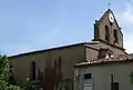 The church from the Northwest
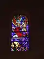
Stained glass window depicting the martyrdom of Saint Stephen 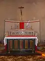 The altar
- Several 'Wayside crosses scattered around the village were used as Oratories. Processions in honour of the Virgin Mary are organized there.[12]
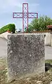 Cross at Aigues-Vives 1
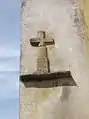 Cross at Aigues-Vives 2
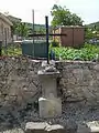 Cross at Aigues-Vives 3
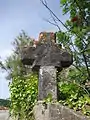 Cross at Aigues-Vives 4
- A Column with a square pedestal, topped by a statue of the Virgin is located in the parking lot near the church. It is about four metres high.
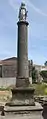 The Column
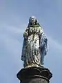 Statue on the Column
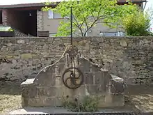
- An Old Fountain with a hand pump which is in no state to use.
- Dry stone huts in ruins, formerly used by farmers.
- Lake Montbel is 5 km southeast of the commune.
- The Ecomuseum of Camping in the Serre.
Notable people
- Faust Nadal, a colonial physician. Born in Aigues-Vives
- Jean Pelissier (1883-1939), a historian, sociologist, and journalist born in Aigues-Vives
See also
Bibliography
- History and Heritage of Mirepoix Country, Mirepoix Tourist Office, 1999, p. 115-119. (in French)
External links
- Aigues-Vives on Lion1906
- Aigues-Vives on Géoportail, National Geographic Institute (IGN) website (in French)
- Aiguesvives on the 1750 Cassini Map
Notes and references
Notes
References
- "Populations légales 2017". INSEE. Retrieved 6 January 2020.
- Inhabitants of (in French)
- Aigues-Vives Archived 2013-12-01 at the Wayback Machine, Jean-Jacques Pétris, website of the Historical Society, consulted on 3 June 2011. (in French)
- Google Maps
- Géoportail, IGN (in French)
- Simplified Geological Map of Ariège, Website of the town council of Vira, consulted on 3 June 2011 (in French)
- Distribution of the ultra-basic body along the Pyrénées mountain chain Archived 2012-11-06 at the Wayback Machine, website of the Academy of Toulouse, consulted on 3 June 2011 (in French)
- Decree No. 2010-1255 of 22 October 2010 to delineate the seismicity zones in French territory in the Aquitaine, Languedoc-Roussillon, and Midi-Pyrénées regions, website of Légifrance, consulted on 3 June 2011 (in French)
- Gaspar database - Risks for the ARIÈGE department Archived 2014-04-07 at the Wayback Machine, website of the Ministry of Ecology, sustainable development, transport and accommodation, consulted on 3 June 2011 (in French)
- Risks for Aigues-Vives Archived 2016-03-03 at the Wayback Machine, website of the Ministry of Ecology, sustainable development, transport and accommodation, consulted on 25 May 2011 (in French)
- General Toponymy of France - non-Roman Forms; dialectal forms, Etymology of 35,000 place names, Ernest Nègre, editor Librairie Droz, Geneva, 1991, vol. 2, 1381 pages, p. 1064, ISBN 978-2-600-00133-5, consulted on 16 May 2011 (in French)
- Official Site of Aigues-Vives, consulted on 16 May 2011 (in French)
- Combs made from the horns of sheep or cattle. See "Peigne en corne" in the French Wikipedia (in French)
- art L. 2121-2 of the General Code of Collective Territories (in French).
- List of Mayors of France (in French)
- Évolution et structure de la population en 2017: Commune d'Aigues-Vives (09002)
- Évolution et structure de la population en 2017: Département de l'Ariège (09)
- Directory of public schools, consulted on 27 May 2011. (in French)
- Dossier complet: Commune d'Aigues-Vives (09002), INSEE, consulted on 9 September 2020 (in French)
- Local Activities, Official website of Aigues-Vives, consulted on 6 June 2011. (in French)
- Michel de La, Ariège, the complete guide to 332 communes], Deslogis-Lacoste, Paris, 1990, ISBN 978-2-7399-5009-2, consulted on 6 June 2011. (in French)
- Presentation of the wind farm Project, consulted on 10 May 2012. (in French)
- Winds of revolt in Cathare country against the industrial wind farm Archived 2016-03-04 at the Wayback Machine, Laurence Cabrol, 23 April 2012, AriègeNews, consulted on 10 May 2012. (in French)
- Ministry of Culture, Palissy PM09000001 Baptismal font (in French)

- Aigues-Vives War Memorial, Gérard Doucet, online 28 January 2011, consulted on 1 June 2011. (in French)
| Wikimedia Commons has media related to Aigues-Vives (Ariège). |