Lescure, Ariège
Lescure (in Occitan Era Escura) is a commune, located in the department of Ariège in the region of Occitanie, in southern France.
Lescure | |
|---|---|
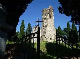 The 12th Century church of Noguès | |
.svg.png.webp) Coat of arms | |
Location of Lescure 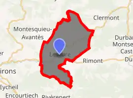
| |
 Lescure  Lescure | |
| Coordinates: 43°00′05″N 1°14′03″E | |
| Country | France |
| Region | Occitanie |
| Department | Ariège |
| Arrondissement | Saint-Girons |
| Canton | Couserans Est |
| Intercommunality | Val-Couserans |
| Government | |
| • Mayor (2008–2014) | Jean-Marie Monreysse |
| Area 1 | 25.8 km2 (10.0 sq mi) |
| Population (2017-01-01)[1] | 499 |
| • Density | 19/km2 (50/sq mi) |
| Time zone | UTC+01:00 (CET) |
| • Summer (DST) | UTC+02:00 (CEST) |
| INSEE/Postal code | 09164 /09420 |
| Elevation | 410–820 m (1,350–2,690 ft) (avg. 493 m or 1,617 ft) |
| 1 French Land Register data, which excludes lakes, ponds, glaciers > 1 km2 (0.386 sq mi or 247 acres) and river estuaries. | |
Its inhabitants are called Escurois.
Geography
Commune of the Pyrenees located in the urban area of Saint - Girons on the Baup . It is part of the Regional Natural Park of the Pyrenees ariégeoises .
Politics and Administration
| List of successive mayors | |||
|---|---|---|---|
| Period | Identity | Label | Quality |
| 2014- In progress | Maryse Perigaud | SE | |
| 2008-2014 | Jean-Marie Monreysse | PS | |
| 2007-2008 | Claude Pujol | PS | |
| 1984-2007 | Michèle Eychenne | ||
| Missing data are to be completed. |
Demographics
In 2014, the municipality had 501 inhabitants, a decrease of -1.18% compared with 2009 ( Ariège : 0.95%, France excluding Mayotte : 2.49%).
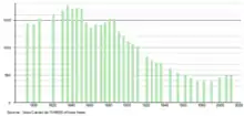
Lescure, Ariège demographics histogram
Places and monuments
The bell tower of Nogues of the thirteenth century is located on the road to Santiago de Compostela. Place currently preserved by the association "Les Amis du Clocher de Nogues". The remains of this ancient church were listed historic monument by decree of June 6, 2012 .
Personalities related to the commune
- Robert Redeker (born 1954), philosopher and writer
- Thierry Escaich (born 1965), organist and composer, born in Nogent-sur-Marne but part of the family of which is attached to Lescure.
- Raoul Béteille (1924-2015), magistrate
See also
References
- "Populations légales 2017". INSEE. Retrieved 6 January 2020.
| Wikimedia Commons has media related to Lescure. |
| Authority control |
|---|
This article is issued from Wikipedia. The text is licensed under Creative Commons - Attribution - Sharealike. Additional terms may apply for the media files.