Aucazein
Aucazein is a commune in the Ariège department in the Occitanie region of south-western France.
Aucazein | |
|---|---|
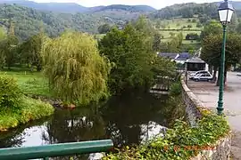 The Bouigane River at Aucazein | |
Location of Aucazein 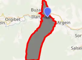
| |
 Aucazein  Aucazein | |
| Coordinates: 42°56′12″N 0°58′32″E | |
| Country | France |
| Region | Occitanie |
| Department | Ariège |
| Arrondissement | Saint-Girons |
| Canton | Couserans Ouest |
| Intercommunality | CC Couserans - Pyrénées |
| Government | |
| • Mayor (2014-2020) | Claude Geslin |
| Area 1 | 6.02 km2 (2.32 sq mi) |
| Population (2017-01-01)[1] | 59 |
| • Density | 9.8/km2 (25/sq mi) |
| Time zone | UTC+01:00 (CET) |
| • Summer (DST) | UTC+02:00 (CEST) |
| INSEE/Postal code | 09025 /09800 |
| Elevation | 531–1,682 m (1,742–5,518 ft) (avg. 550 m or 1,800 ft) |
| 1 French Land Register data, which excludes lakes, ponds, glaciers > 1 km2 (0.386 sq mi or 247 acres) and river estuaries. | |
The inhabitants of the commune are known as Aucazénois.[2]
Geography
Aucazein is located in the Ariège Natural Regional Park some 40 km south-east of Saint-Gaudens in a direct line and 20 km west by south-west of Saint-Girons at an altitude of 570 metres. Access to the commune is by road D 618 from Orgibet in the west which passes through the north of the commune and the village and continues east to Argein. Most of the land area of the commune is rugged and forested however the valley where the village is located has some farmland.[3]
The Bouigane river flows east along the valley and through the village on its way to join the Lez at Audressein. The Ruisseau de Cassech forms the western border of the commune as it flows north to join the Bouigane. Similarly La Rivière forms the eastern border of the commune and also joins the Bouigane. The Ruisseau de Recoule flows from the north and passes through the commune for a short distance before joining the Bouigane.[3]
History
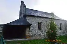
The commune is located on the Way of St. James which crosses Ariège. The Knights Templar built a Romanesque chapel in the commune.
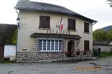
Administration
List of Successive Mayors[4]
| From | To | Name | Party | Position |
|---|---|---|---|---|
| 2001 | 2008 | Claude Vignes | ||
| 2008 | 2014 | Claude Dupuy | ||
| 2014 | 2020 | Claude Geslin |
(Not all data is known)
Demography
In 2017 the commune had 59 inhabitants.
|
| ||||||||||||||||||||||||||||||||||||||||||||||||||||||||||||||||||||||||||||||||||||||||||||||||||||||||||||||||||
| Source: EHESS[5] and INSEE[6] | |||||||||||||||||||||||||||||||||||||||||||||||||||||||||||||||||||||||||||||||||||||||||||||||||||||||||||||||||||
Sites and monuments
The commune has one site that is registered as a historical monument:
- An Ornamental Garden
 [7]
[7]
The commune has some other sites of interest:
See also
References
- "Populations légales 2017". INSEE. Retrieved 6 January 2020.
- Inhabitants of Ariège (in French)
- Google Maps
- List of Mayors of France (in French)
- Données Cassini, EHESS
- Population en historique depuis 1968, INSEE
- Ministry of Culture, Mérimée IA09000020 Ornamental Garden (in French)
External links
- Aucazein on Lion1906
- Aucazein on Géoportail, National Geographic Institute (IGN) website (in French)
- Aucasein on the 1750 Cassini Map
| Wikimedia Commons has media related to Aucazein. |