Axiat
Axiat is a commune in the Ariège department in the Occitanie region of southwestern France.
Axiat | |
|---|---|
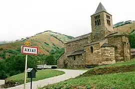 The church in Axiat | |
Location of Axiat 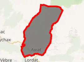
| |
 Axiat  Axiat | |
| Coordinates: 42°47′05″N 1°45′25″E | |
| Country | France |
| Region | Occitanie |
| Department | Ariège |
| Arrondissement | Foix |
| Canton | Haute-Ariège |
| Intercommunality | CC Haute-Ariège |
| Government | |
| • Mayor (2014-2020) | Maurice Sicre |
| Area 1 | 9.54 km2 (3.68 sq mi) |
| Population (2017-01-01)[1] | 41 |
| • Density | 4.3/km2 (11/sq mi) |
| Time zone | UTC+01:00 (CET) |
| • Summer (DST) | UTC+02:00 (CEST) |
| INSEE/Postal code | 09031 /09250 |
| Elevation | 707–2,365 m (2,320–7,759 ft) (avg. 880 m or 2,890 ft) |
| 1 French Land Register data, which excludes lakes, ponds, glaciers > 1 km2 (0.386 sq mi or 247 acres) and river estuaries. | |
The inhabitants of the commune are known as Axiatois or Axiatoises.[2]
Geography
Axiat is located some 27 km south-east of Foix and some 12 km north-west of Ax-les-Thermes. Access to the commune is by the D20 road from Appy in the west which passes through the south of the commune and the village before continuing south to Lordat. The commune is alpine in nature with snow-capped mountains in the north, extensive forests, and rugged terrain. There is some farming activity in the south near the village.[3]
The Ruisseau d'Axiat forms the southern border of the commune as it flows west to join the Ariege at Urs. The Ruisseau de la Cassagne forms the south-western border of the commune as it flows south to join the Ruisseau d'Axiat. The Ruisseau de Girabel forms the north-western border of the commune as it flows south to join the Ruisseau de la Cassagne. The Ruisseau de Sauquet rises in the north of the commune and flows south through the centre near the village and joins the Ruisseau d'Axiat on the southern border. The Ruisseau de Fontronne forms the eastern border of the commune as it flows south to join the Ruisseau d'Axiat on the southern border.[3]
There is also a hamlet called Axiat in the commune of Miglos.
Administration
List of Successive Mayors[4]
| From | To | Name | Party | Position |
|---|---|---|---|---|
| 2001 | 2020 | Maurice Sicre |
(Not all data is known)
Demography
In 2017 the commune had 41 inhabitants.
|
| ||||||||||||||||||||||||||||||||||||||||||||||||||||||||||||||||||||||||||||||||||||||||||||||||||||||||||||||||||
| Source: EHESS[5] and INSEE[6] | |||||||||||||||||||||||||||||||||||||||||||||||||||||||||||||||||||||||||||||||||||||||||||||||||||||||||||||||||||
Culture and heritage
Religious heritage
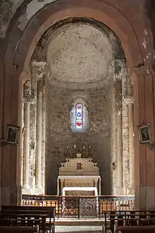
The Church of Saint Julien (11th century)![]() is registered as an historical monument.[7]
is registered as an historical monument.[7]
- Photos of the Church
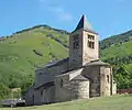 Exterior of the Church
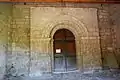 A door to the Church
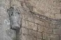 A detail of the wall
 The Baptismal font
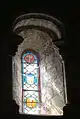 A Stained glass window
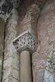 A detail of the wall
Environmental heritage
- The Soularac Peak (2,368 m)
- The Saint-Barthélemy Peak (2,348 m)
See also
References
- "Populations légales 2017". INSEE. Retrieved 6 January 2020.
- Inhabitants of Ariège (in French)
- Google Maps
- List of Mayors of France (in French)
- Données Cassini, EHESS
- Population en historique depuis 1968, INSEE
- Ministry of Culture, Mérimée PA00093771 Church of Saint Julien (in French)

External links
- Axiat on the old IGN website (in French)
- Axiat on Lion1906
- Axiat on Géoportail, National Geographic Institute (IGN) website (in French)
- Axiat on the 1750 Cassini Map
| Wikimedia Commons has media related to Axiat. |