Angeac-Champagne
Angeac-Champagne is a commune in the Charente department in the Nouvelle-Aquitaine region of southwestern France.
Angeac-Champagne | |
|---|---|
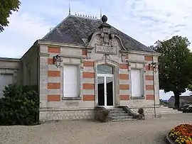 Town hall | |
 Coat of arms | |
Location of Angeac-Champagne 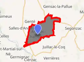
| |
 Angeac-Champagne  Angeac-Champagne | |
| Coordinates: 45°36′30″N 0°17′47″W | |
| Country | France |
| Region | Nouvelle-Aquitaine |
| Department | Charente |
| Arrondissement | Cognac |
| Canton | Charente-Champagne |
| Intercommunality | Grand Cognac |
| Government | |
| • Mayor (2014-2020) | Gérard Faurie |
| Area 1 | 14.27 km2 (5.51 sq mi) |
| Population (2017-01-01)[1] | 509 |
| • Density | 36/km2 (92/sq mi) |
| Time zone | UTC+01:00 (CET) |
| • Summer (DST) | UTC+02:00 (CEST) |
| INSEE/Postal code | 16012 /16130 |
| Elevation | 17–83 m (56–272 ft) (avg. 71 m or 233 ft) |
| 1 French Land Register data, which excludes lakes, ponds, glaciers > 1 km2 (0.386 sq mi or 247 acres) and river estuaries. | |
The inhabitants of the commune are known as Angeacais or Angeacaises.[2]
Geography
Location and access
Angeac-Champagne is a commune located in the west of the department of Charente, near Charente-Maritime, in Grande Champagne, the premier cru of cognac.
The commune is located 10 km south of Cognac, 6 km west of Segonzac, and 3 km east of Salles-d'Angles. Angoulême, the prefecture of Charente, is 35 km to the east. Angeac is also 9 km north of Archiac, 12 km south-west of Jarnac, and 19 km north-west of Saint-Hilaire.[3]
The commune does not lie on any main roads. The D731 road from Barbezieux to Cognac via Archiac, passes through the west of the commune. The village is served by the D150 from Germignac in the south-east and passes through the village before continuing north-east to join the D44 from Juillac-le-Coq to Roissac towards Cognac and Gensac-la-Pallue. A country road leads to the village of Salles-d'Angles and another to Genté in the north-west.[4]
The nearest train station is at Cognac which is served by the TER between Angoulême, Saintes, and Royan.
Hamlets and localities
There are many hamlets dotting the commune. In particular Roissac, located northeast of Angeac village, was an ancient parish, and the village is as important as Angeac.
The small village of Le Bois d'Angeac together with a small forest is located 1 km north-west of the village.[5]
Apart from a few small patches of forest the commune is entirely farmland[5]
Neighbouring communes and villages
Places adjacent to Angeac-Champagne | ||||||||||
|---|---|---|---|---|---|---|---|---|---|---|
| ||||||||||
Geology and relief
As with the whole left bank of the Charente between Angoulême and Cognac, this area is limestone dating from the Cretaceous period with Cuestas.
The commune is part of the Campanian (Late Cretaceous) chalky limestone area which occupies a large part of South Charente. There is also some Santonian rock on a small part of the northern border at Longées.
The Campanian cuesta passes through the commune. This escarpment starts in the west at Salles-d'Angles, passes the foot of the town of Genté, then runs through the whole department going east towards Bouteville, Jurignac, and Plassac-Rouffiac. In the commune the escarpment passes through the east as an inlier northeast of Roissac. It separates the north of the plain of Châteaubernard from Champagne to the south.[6][7][8]
The highest point in the commune is at an altitude of 84 m located north-west of Roissac. Another high point of 83 m faces it to the east (topped by an IGN Survey marker). The lowest point is 17 m located in Pas de la Tombe on the south-west edge of the commune near Salles d'Angles. The commune mostly varies in height between 40 and 70 m above sea level.[4]
Hydrography
The Ruisseau de la Motte, a small tributary of the Né River and thus a sub-tributary of the Charente, forms the commune boundary to the south. No other rivers pass through the commune but there are many pools in a valley west of the village and towards Roissac[4] and some springs including the Three Stones east of Bois d'Angeac.
Climate
The climate is oceanic Aquitaine.
Toponymy
The word Angeac is derived from the Latin Andiacum or villa Andii meaning that the village was built around the property of a rich Gallo-Roman named Andius. The term Champagne was added to the name of the town in 1801 to distinguish it from its namesake Angeac-Charente. In Saintonge the term Champagne refers to a fertile plain of limestone. It is derived from the Latin campus meaning "field" or "plain".
The word Roissac is derived from the Latin Riatacum or villa Riatii meaning that the village was built around the property of a rich Gallo-Roman named Riatus.[9]
History
Proto-historic circular Ditches exist in the areas of Penchant de Lorimont and Houme, with square and circular ones at a place called Les Chirons. Roman villas are said to be at Puits d'Angeac at Chabanne and there are some medieval remains at Branges.[10]
The remains of a Gallo-Roman villa possibly dating to the first half of the 9th century were found in 1904. It was a residence of Louis the Pious. These remains have disappeared.
Angeac was first a dependency of the Templars then passed to the Marquisate of Archiac then often changed hands. In 1239 Roissac passed to the House of Angoulême then at Barbezieux. By marriage Roissac became allied with Salles-d'Angles and Genté. The rights to the marshes resulted in brawls and lawsuits with the Lordship of Gademoulin.
The commune of Angeac was created in 1793 when it belonged to the Canton of Salles in district of Cognac and the Charente department. In 1801 it took the name of Champagne and was attached to the Canton de Segonzac.
The Roissac railway station was served from 1910 to 1939 by the Chemins de fer économiques des Charentes (Cheap Trains of Charente) with a metre gauge line from Cognac to Barbezieux with 3 return trips a day at a speed of 20 km/h. This line also served stations at Cognac, Genté, Segonzac, Juillac-le-Coq, Saint-Fort-sur-le-Né, Archiac, and Barbezieux.
Heraldry
Arms of Angeac-Champagne |
Blazon: Azure, an escutcheon of Or. |
Administration
List of Successive Mayors[11]
| From | To | Name | Party | Position |
|---|---|---|---|---|
| 2001 | 2008 | Bernadette Jullien | ||
| 2008 | Current | Gérard Faurie | SE | Lawyer |
(Not all data is known)
Population
| Year | Pop. | ±% |
|---|---|---|
| 2006 | 497 | — |
| 2007 | 499 | +0.4% |
| 2008 | 510 | +2.2% |
| 2009 | 510 | +0.0% |
| 2010 | 507 | −0.6% |
| 2011 | 505 | −0.4% |
| 2012 | 502 | −0.6% |
| 2013 | 509 | +1.4% |
| 2014 | 510 | +0.2% |
| 2015 | 509 | −0.2% |
| 2016 | 509 | +0.0% |
Distribution of Age Groups
Percentage Distribution of Age Groups in Angeac-Champagne and Charente Department in 2017
| Angeac-Champagne | Charente | |||
|---|---|---|---|---|
| Age Range | Men | Women | Men | Women |
| 0 to 14 Years | 17.4 | 16.7 | 16.7 | 14.8 |
| 15 to 29 Years | 14.8 | 13.4 | 15.7 | 13.8 |
| 30 to 44 Years | 16.7 | 16.3 | 17.1 | 16.3 |
| 45 to 59 Years | 22.2 | 26.4 | 21.1 | 20.8 |
| 60 to 74 Years | 21.9 | 18.8 | 19.6 | 19.8 |
| 75 to 89 Years | 7.0 | 7.1 | 8.9 | 12.0 |
| 90 Years+ | 0.0 | 1.3 | 0.9 | 2.4 |
Facilities, services, and local life
Education
The school is an educational inter-communal grouping between Angeac-Champagne and Salles-d'Angles. Angeac-Champagne has a kindergarten and Salles-d'Angles an elementary school.[14]
Culture and heritage

The commune contains a very large number of buildings and structures that are registered as historical monuments.[15] Some of the more interesting sites are described below.
Civil heritage
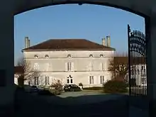
- The Chateau de Roissac (18th century).
 The Chateau bears the date 1830 but it was a chateau built in the Middle Ages for the La Rochefoucauld family at the site of a Gallo-Roman villa. The present chateau was built for the Beauchamp family around 1770 and the date 1830 with the initials I.P. corresponds to the remains of the outbuildings. There are decorations and, especially in the living room, wood paneling adorned with paintings of birds, flowers, fruit, landscapes, a scene with a sower, Moses and the Tablets of the Law.[16][17]
 - The Duran S.A. Distillery (1968)[18]
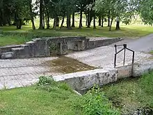
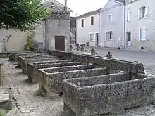
- The Fountain, Lavoir (Public Laundry), and drinking trough at Roissac.[19] They are linked to François I who would have visited the Chateau de Roissac for hunting.
- The Girls' School at Roissac.[20]
- A Watermill at La Motte (in ruins)[21] joined to that of Saint-Fort-sur-le-Né.
- A Windmill at La Millière (19th century)[22]
- A Manor at Lorimont (1831).[23] According to Martin Civat it already existed in the 16th century and was rebuilt in the 19th century. It bears the inscription "FAIT EN 1831 CHAILLOU PAUL" (Made in 1831 Chaillou Paul).
- An Underground refuge (Antiquity).[24] A staircase to the refuge has been identified but its location remains unknown.
- An Ancient Villa of Louis the Pious (Antiquity).[25]
- The Logis d'Angeac Manor (1733).[26] This is a manor that dates in part to the 16th century. When René de la Tour bought it in 1657 the house was to the north. The outbuildings are dated 1733. Another house was built to the west and rebuilt in the 19th century with outbuildings to the south. The entrance gate bears the date 1882.
Religious heritage
- A Cemetery Cross (19th century)[30]
- The Pinard Family Funeral Chapel (19th century)[31]
- The Renaud Family Funeral Chapel (19th century)[32]
- The Frapin Gimbelot Prioulat Family Funeral Chapel (19th century)[33]
- The Cemetery (19th century)[34]
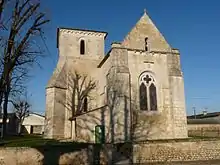
- The Parish Church of Saint-Vivien (11th century)[35] The church was built in the 11th century and partly rebuilt in 1534 then repaired at the expense of the priest, Jean Marcus, in 1748 then restored again in 1864. Finally it was vaulted in 1875. It is elongated like a ship and covered by a ribbed vault. The Church contains many items that are registered as historical objects:
- The Furniture in the Church
 [36]
[36] - A Bronze Bell (1783)[37]
- 2 Vases (19th century)[38][39]
- 2 Monstrances (19th century)[40][41]
- A Paten (19th century)[42]
- A Chalice (1884)[43]
- A Stoup (1874)[44]
- A Baptismal font (19th century)[45]
- A Pulpit (1879)[46]
- A Secondary Altar and Tabernacle (19th century)[47]
- The main Altar and Tabernacle (1897)[48]
- A Stained glass window (19th century)[49]
- A Stained glass window of Saint Theresa of Lisieux (1947)[50]
- A Stained glass window of Saint Francis of Sales (19th century)[51]
- A Stained glass window of Saint Joseph, Virgin, and child (19th century)[52]
- 2 Stained glass windows (19th century)[53]
- 2 Stained glass windows of Saints Peter and Paul (19th century)[54]
- 3 Stained glass figures (19th century)[55]
- The Furniture in the Church
See also
External links
References
- "Populations légales 2017". INSEE. Retrieved 6 January 2020.
- Inhabitants of Charente (in French)
- Orthodromic Distances prises from ACME Mapper (in French)
- IGN map on Géoportail (in French)
- Google Maps
- BRGM map on Géoportail (in French)
- Infoterre Visualiser Archived 2017-04-23 at the Wayback Machine, BRGM website (in French)
- Paper Notice for Cognac, BRGM, Infoterre website, 20 November 2011 (in French)
- Jean-Marie Cassagne and Stéphane Seguin, Origins of the names of towns and villages of Charente, Jean-Michel Bordessoules, 1998, 311 pages, p. 14 and 229, ISBN 2-913471-06-4 (in French)
- Christian Vernou, The Charente, Maison des Sciences de l'Homme, Paris, coll. "Archeological Map of Gaul", 1993, 253 p. (ISBN 2-87754-025-1), p. 200-201 (in French)
- List of Mayors of France
- Évolution et structure de la population en 2017: Commune d'Angeac-Champagne(16012)
- Évolution et structure de la population en 2017: Département de la Charente (16)
- Academic Inspection of Charente website (in French)
- Base Mérimée: Search for heritage in the commune, Ministère français de la Culture. (in French)
- Ministry of Culture, Mérimée PA00104551 Chateau de Roissac (in French)
- Ministry of Culture, Mérimée IA00042033 Chateau de Roissac (in French)
- Ministry of Culture, Mérimée IA00066107 Duran S.A. Distillery (in French)

- Ministry of Culture, Mérimée IA00042032 Fountain, Lavoir, and drinking trough (in French)
- Ministry of Culture, Mérimée IA00042031 Girls' School (in French)
- Ministry of Culture, Mérimée IA00041994 Watermill (in French)
- Ministry of Culture, Mérimée IA00041993 Windmill (in French)
- Ministry of Culture, Mérimée IA00041992 Manor at Lorimont (in French)
- Ministry of Culture, Mérimée IA00041979 Underground Refuge (in French)
- Ministry of Culture, Mérimée IA00041978 Ancient Villa (in French)
- Ministry of Culture, Mérimée IA00041977 Logis d'Angeac Manor (in French)
- Ministry of Culture, Mérimée IA00041976 War Memorial (in French)
- Ministry of Culture, Mérimée IA00041975 Town Hall (in French)
- Ministry of Culture, Mérimée IA00041965 Farmhouses (in French)
- Ministry of Culture, Mérimée IA00041968 Cemetery Cross (in French)
- Ministry of Culture, Mérimée IA00041969 Pinard Family Funeral Chapel (in French)
- Ministry of Culture, Mérimée IA00041971 Renaud Family Funeral Chapel (in French)
- Ministry of Culture, Mérimée IA00041973 Frapin Gimbelot Prioulat Family Funeral Chapel (in French)
- Ministry of Culture, Mérimée IA00041967 Cemetery (in French)
- Ministry of Culture, Mérimée IA00041966 Parish Church of Saint-Vivien (in French)
- Ministry of Culture, Palissy IM16000443 Furniture in the Church (in French)
- Ministry of Culture, Palissy IM16000442 Bronze Bell (in French)
- Ministry of Culture, Palissy IM16000441 Vase (in French)
- Ministry of Culture, Palissy IM16000440 Vase (in French)
- Ministry of Culture, Palissy IM16000439 Monstrance (in French)
- Ministry of Culture, Palissy IM16000438 Monstrance (in French)
- Ministry of Culture, Palissy IM16000437 Paten (in French)
- Ministry of Culture, Palissy IM16000436 Chalice (in French)
- Ministry of Culture, Palissy IM16000435 Stoup (in French)
- Ministry of Culture, Palissy IM16000434 Baptismal font (in French)
- Ministry of Culture, Palissy IM16000433 Pulpit (in French)
- Ministry of Culture, Palissy IM16000432 Secondary Altar and Tabernacle (in French)
- Ministry of Culture, Palissy IM16000431 Main Altar and Tabernacle (in French)
- Ministry of Culture, Palissy IM16000430 Stained glass window (in French)
- Ministry of Culture, Palissy IM16000429 Stained glass window of Saint Theresa of Lisieux (in French)
- Ministry of Culture, Palissy IM16000428 Stained glass window of Saint Francis of Sales (in French)
- Ministry of Culture, Palissy IM16000427 Stained glass window of Saint Joseph, Virgin, and child (in French)
- Ministry of Culture, Palissy IM16000426 2 Stained glass windows (in French)
- Ministry of Culture, Palissy IM16000425 2 Stained glass windows of Saints Peter and Paul (in French)
- Ministry of Culture, Palissy IM16000424 3 Stained glass figures (in French)
| Wikimedia Commons has media related to Angeac-Champagne. |
| Authority control |
|---|