Blanzaguet-Saint-Cybard
Blanzaguet-Saint-Cybard is a commune in the Charente department in southwestern France.
Blanzaguet-Saint-Cybard | |
|---|---|
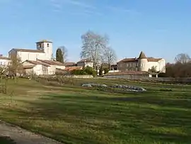 A general view of Blanzaguet | |
Location of Blanzaguet-Saint-Cybard 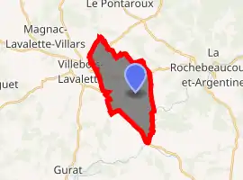
| |
 Blanzaguet-Saint-Cybard  Blanzaguet-Saint-Cybard | |
| Coordinates: 45°28′15″N 0°19′16″E | |
| Country | France |
| Region | Nouvelle-Aquitaine |
| Department | Charente |
| Arrondissement | Angoulême |
| Canton | Tude-et-Lavalette |
| Government | |
| • Mayor (2008–2014) | Guy Vautour |
| Area 1 | 11.95 km2 (4.61 sq mi) |
| Population (2017-01-01)[1] | 296 |
| • Density | 25/km2 (64/sq mi) |
| Time zone | UTC+01:00 (CET) |
| • Summer (DST) | UTC+02:00 (CEST) |
| INSEE/Postal code | 16047 /16320 |
| Elevation | 82–162 m (269–531 ft) (avg. 102 m or 335 ft) |
| 1 French Land Register data, which excludes lakes, ponds, glaciers > 1 km2 (0.386 sq mi or 247 acres) and river estuaries. | |
Geography
The Lizonne forms part of the commune's southeastern border.
Population
| Year | Pop. | ±% |
|---|---|---|
| 1793 | 347 | — |
| 1800 | 341 | −1.7% |
| 1806 | 365 | +7.0% |
| 1821 | 355 | −2.7% |
| 1831 | 341 | −3.9% |
| 1841 | 313 | −8.2% |
| 1846 | 329 | +5.1% |
| 1851 | 363 | +10.3% |
| 1856 | 346 | −4.7% |
| 1861 | 577 | +66.8% |
| 1866 | 566 | −1.9% |
| 1872 | 503 | −11.1% |
| 1876 | 499 | −0.8% |
| 1881 | 482 | −3.4% |
| 1886 | 415 | −13.9% |
| 1891 | 441 | +6.3% |
| 1896 | 403 | −8.6% |
| 1901 | 390 | −3.2% |
| 1906 | 419 | +7.4% |
| 1911 | 391 | −6.7% |
| 1921 | 389 | −0.5% |
| 1926 | 362 | −6.9% |
| 1931 | 362 | +0.0% |
| 1936 | 371 | +2.5% |
| 1946 | 362 | −2.4% |
| 1954 | 364 | +0.6% |
| 1962 | 304 | −16.5% |
| 1968 | 280 | −7.9% |
| 1975 | 255 | −8.9% |
| 1982 | 252 | −1.2% |
| 1990 | 223 | −11.5% |
| 1999 | 216 | −3.1% |
| 2008 | 249 | +15.3% |
See also
References
- "Populations légales 2017". INSEE. Retrieved 6 January 2020.
| Wikimedia Commons has media related to Blanzaguet-Saint-Cybard. |
| Authority control |
|---|
This article is issued from Wikipedia. The text is licensed under Creative Commons - Attribution - Sharealike. Additional terms may apply for the media files.