Saint-Claud
Saint-Claud is a commune in the Charente department in southwestern France.
Saint-Claud | |
|---|---|
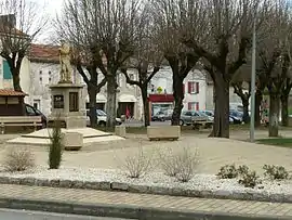 Market place | |
 Coat of arms | |
Location of Saint-Claud 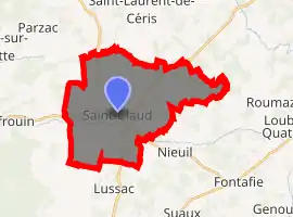
| |
 Saint-Claud  Saint-Claud | |
| Coordinates: 45°53′46″N 0°27′56″E | |
| Country | France |
| Region | Nouvelle-Aquitaine |
| Department | Charente |
| Arrondissement | Confolens |
| Canton | Charente-Bonnieure |
| Intercommunality | Charente Limousine |
| Government | |
| • Mayor (2020–2026) | Pascal Dubuisson |
| Area 1 | 26.75 km2 (10.33 sq mi) |
| Population (2017-01-01)[1] | 1,057 |
| • Density | 40/km2 (100/sq mi) |
| Time zone | UTC+01:00 (CET) |
| • Summer (DST) | UTC+02:00 (CEST) |
| INSEE/Postal code | 16308 /16450 |
| Elevation | 107–222 m (351–728 ft) (avg. 144 m or 472 ft) |
| 1 French Land Register data, which excludes lakes, ponds, glaciers > 1 km2 (0.386 sq mi or 247 acres) and river estuaries. | |
The small commune is located northeast of Angoulême.
Population
|
|
Personalities
The commune is partly the ancestral home of Sir Wilfrid Laurier, Prime Minister of Canada from 1896 to 1911 (Laurier's ancestor was François Cottineau, who left his home named Champlaurier, located between the villages of Saint-Claud and Nieuil, for New France in 1677 as the member of the Régiment de Carignan-Salières). It was also the birthplace of the phonetician Jean-Pierre Rousselot.
See also
References
- "Populations légales 2017". INSEE. Retrieved 6 January 2020.
| Wikimedia Commons has media related to Saint-Claud. |
| Authority control |
|
|---|
This article is issued from Wikipedia. The text is licensed under Creative Commons - Attribution - Sharealike. Additional terms may apply for the media files.