Empuré
Empuré is a commune in the Charente department in southwestern France.
Empuré | |
|---|---|
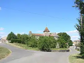 The church and surroundings in Empuré | |
Location of Empuré 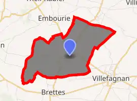
| |
 Empuré  Empuré | |
| Coordinates: 46°01′25″N 0°03′09″E | |
| Country | France |
| Region | Nouvelle-Aquitaine |
| Department | Charente |
| Arrondissement | Confolens |
| Canton | Charente-Nord |
| Government | |
| • Mayor (2020–2026) | Francis Marquet[1] |
| Area 1 | 8.37 km2 (3.23 sq mi) |
| Population (2017-01-01)[2] | 100 |
| • Density | 12/km2 (31/sq mi) |
| Time zone | UTC+01:00 (CET) |
| • Summer (DST) | UTC+02:00 (CEST) |
| INSEE/Postal code | 16127 /16240 |
| Elevation | 84–156 m (276–512 ft) (avg. 100 m or 330 ft) |
| 1 French Land Register data, which excludes lakes, ponds, glaciers > 1 km2 (0.386 sq mi or 247 acres) and river estuaries. | |
Bounded on the west by the Fountaine de Frédières, a small tributary of the Aume, the town lies on a plateau, located 3 km northwest of Villefagnan and 13 km west of Ruffec. The main crop is cereals.
The main route is the D27 route which crosses the commune from the north-west to south-east, which passes near the town of Empuré. The communes contains the hamlets Planchard in the west bordering the commune of Paizay-Naudouin-Embourie, Le Pouyaud to the north of the town and Bellevue etc.
Population
|
|
Sights
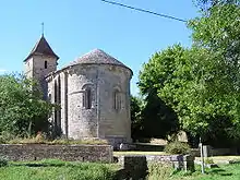
Église Saint-Maixent, a remarkable building from the twelfth century is characterised by its arched gateway, and the symbolic corbels that adorn its façade. It was classified a historical monument on May 9, 1914.
There is also a chateau in the commune and a town hall, built in the 16th century.
See also
References
- "Répertoire national des élus: les maires". data.gouv.fr, Plateforme ouverte des données publiques françaises (in French). 2 December 2020. Retrieved 7 December 2020.
- "Populations légales 2017". INSEE. Retrieved 6 January 2020.
| Wikimedia Commons has media related to Empuré. |