Roullet-Saint-Estèphe
Roullet-Saint-Estèphe is a commune in the Charente department in southwestern France.
Roullet-Saint-Estèphe | |
|---|---|
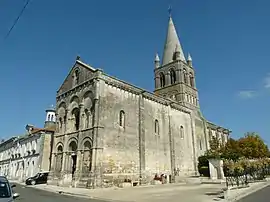 Église Saint-Cybard de Roullet | |
.svg.png.webp) Coat of arms | |
Location of Roullet-Saint-Estèphe 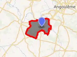
| |
 Roullet-Saint-Estèphe  Roullet-Saint-Estèphe | |
| Coordinates: 45°35′04″N 0°02′54″E | |
| Country | France |
| Region | Nouvelle-Aquitaine |
| Department | Charente |
| Arrondissement | Angoulême |
| Canton | Boëme-Échelle |
| Intercommunality | Charente-Boëme-Charraud |
| Government | |
| • Mayor (2008–2014) | Jean-Paul Kerjean |
| Area 1 | 41.50 km2 (16.02 sq mi) |
| Population (2017-01-01)[1] | 4,262 |
| • Density | 100/km2 (270/sq mi) |
| Time zone | UTC+01:00 (CET) |
| • Summer (DST) | UTC+02:00 (CEST) |
| INSEE/Postal code | 16287 /16440 |
| Elevation | 22–139 m (72–456 ft) (avg. 26 m or 85 ft) |
| 1 French Land Register data, which excludes lakes, ponds, glaciers > 1 km2 (0.386 sq mi or 247 acres) and river estuaries. | |
Population
| Year | Pop. | ±% |
|---|---|---|
| 1793 | 1,136 | — |
| 1800 | 921 | −18.9% |
| 1806 | 1,188 | +29.0% |
| 1821 | 1,291 | +8.7% |
| 1831 | 1,350 | +4.6% |
| 1841 | 1,462 | +8.3% |
| 1846 | 1,464 | +0.1% |
| 1851 | 1,475 | +0.8% |
| 1856 | 1,388 | −5.9% |
| 1861 | 1,395 | +0.5% |
| 1866 | 1,373 | −1.6% |
| 1872 | 1,313 | −4.4% |
| 1876 | 1,245 | −5.2% |
| 1881 | 1,274 | +2.3% |
| 1886 | 1,254 | −1.6% |
| 1891 | 1,187 | −5.3% |
| 1896 | 1,205 | +1.5% |
| 1901 | 1,225 | +1.7% |
| 1906 | 1,232 | +0.6% |
| 1911 | 1,226 | −0.5% |
| 1921 | 1,127 | −8.1% |
| 1926 | 1,179 | +4.6% |
| 1931 | 1,238 | +5.0% |
| 1936 | 1,173 | −5.3% |
| 1946 | 1,235 | +5.3% |
| 1954 | 1,282 | +3.8% |
| 1962 | 1,354 | +5.6% |
| 1968 | 1,538 | +13.6% |
| 1975 | 2,304 | +49.8% |
| 1982 | 2,953 | +28.2% |
| 1990 | 3,378 | +14.4% |
| 1999 | 3,480 | +3.0% |
| 2008 | 3,747 | +7.7% |
See also
References
- "Populations légales 2017". INSEE. Retrieved 6 January 2020.
| Wikimedia Commons has media related to Roullet-Saint-Estèphe. |
| Authority control |
|---|
This article is issued from Wikipedia. The text is licensed under Creative Commons - Attribution - Sharealike. Additional terms may apply for the media files.