Saint-Amant-de-Boixe
Saint-Amant-de-Boixe is a commune in the Charente department in southwestern France.
Saint-Amant-de-Boixe | |
|---|---|
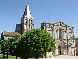 The abbey in Saint-Amant-de-Boixe | |
Location of Saint-Amant-de-Boixe 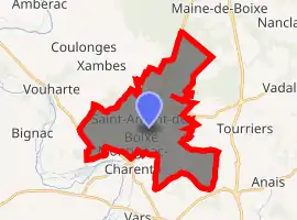
| |
 Saint-Amant-de-Boixe  Saint-Amant-de-Boixe | |
| Coordinates: 45°47′56″N 0°08′08″E | |
| Country | France |
| Region | Nouvelle-Aquitaine |
| Department | Charente |
| Arrondissement | Confolens |
| Canton | Boixe-et-Manslois |
| Government | |
| • Mayor (2008–2014) | Bernard Lacœuille |
| Area 1 | 22.39 km2 (8.64 sq mi) |
| Population (2017-01-01)[1] | 1,370 |
| • Density | 61/km2 (160/sq mi) |
| Time zone | UTC+01:00 (CET) |
| • Summer (DST) | UTC+02:00 (CEST) |
| INSEE/Postal code | 16295 /16330 |
| Elevation | 41–139 m (135–456 ft) (avg. 109 m or 358 ft) |
| 1 French Land Register data, which excludes lakes, ponds, glaciers > 1 km2 (0.386 sq mi or 247 acres) and river estuaries. | |
Population
|
|
See also
References
- "Populations légales 2017". INSEE. Retrieved 6 January 2020.
| Wikimedia Commons has media related to Saint-Amant-de-Boixe. |
| Authority control |
|---|
This article is issued from Wikipedia. The text is licensed under Creative Commons - Attribution - Sharealike. Additional terms may apply for the media files.
