Saint-Laurent-de-Céris
Saint-Laurent-de-Céris is a commune in the Charente department in southwestern France.
Saint-Laurent-de-Céris | |
|---|---|
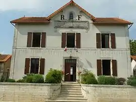 Town hall | |
.svg.png.webp) Coat of arms | |
Location of Saint-Laurent-de-Céris 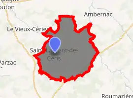
| |
 Saint-Laurent-de-Céris  Saint-Laurent-de-Céris | |
| Coordinates: 45°56′32″N 0°28′54″E | |
| Country | France |
| Region | Nouvelle-Aquitaine |
| Department | Charente |
| Arrondissement | Confolens |
| Canton | Charente-Bonnieure |
| Intercommunality | Haute-Charente |
| Government | |
| • Mayor (2008–2014) | Yves Gendry |
| Area 1 | 29.89 km2 (11.54 sq mi) |
| Population (2017-01-01)[1] | 778 |
| • Density | 26/km2 (67/sq mi) |
| Time zone | UTC+01:00 (CET) |
| • Summer (DST) | UTC+02:00 (CEST) |
| INSEE/Postal code | 16329 /16450 |
| Elevation | 127–209 m (417–686 ft) (avg. 190 m or 620 ft) |
| 1 French Land Register data, which excludes lakes, ponds, glaciers > 1 km2 (0.386 sq mi or 247 acres) and river estuaries. | |
Population
| Year | Pop. | ±% |
|---|---|---|
| 1793 | 1,059 | — |
| 1800 | 942 | −11.0% |
| 1806 | 1,018 | +8.1% |
| 1821 | 1,055 | +3.6% |
| 1831 | 1,183 | +12.1% |
| 1841 | 1,299 | +9.8% |
| 1846 | 1,350 | +3.9% |
| 1851 | 1,425 | +5.6% |
| 1856 | 1,380 | −3.2% |
| 1861 | 1,305 | −5.4% |
| 1866 | 1,263 | −3.2% |
| 1872 | 1,275 | +1.0% |
| 1876 | 1,315 | +3.1% |
| 1881 | 1,417 | +7.8% |
| 1886 | 1,444 | +1.9% |
| 1891 | 1,394 | −3.5% |
| 1896 | 1,327 | −4.8% |
| 1901 | 1,242 | −6.4% |
| 1906 | 1,311 | +5.6% |
| 1911 | 1,217 | −7.2% |
| 1921 | 1,114 | −8.5% |
| 1926 | 1,119 | +0.4% |
| 1931 | 1,157 | +3.4% |
| 1936 | 1,104 | −4.6% |
| 1946 | 1,071 | −3.0% |
| 1954 | 1,110 | +3.6% |
| 1962 | 1,040 | −6.3% |
| 1968 | 1,001 | −3.7% |
| 1975 | 883 | −11.8% |
| 1982 | 802 | −9.2% |
| 1990 | 741 | −7.6% |
| 1999 | 746 | +0.7% |
| 2008 | 758 | +1.6% |
See also
References
- "Populations légales 2017". INSEE. Retrieved 6 January 2020.
| Wikimedia Commons has media related to Saint-Laurent-de-Céris. |
| Authority control |
|---|
This article is issued from Wikipedia. The text is licensed under Creative Commons - Attribution - Sharealike. Additional terms may apply for the media files.