Antezant-la-Chapelle
Antezant-la-Chapelle is a commune in the Charente-Maritime department in the Nouvelle-Aquitaine region in southwestern France.
Antezant-la-Chapelle | |
|---|---|
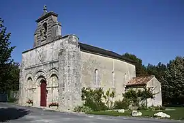 The church in Antezant-la-Chapelle | |
Location of Antezant-la-Chapelle 
| |
 Antezant-la-Chapelle  Antezant-la-Chapelle | |
| Coordinates: 45°59′00″N 0°27′18″W | |
| Country | France |
| Region | Nouvelle-Aquitaine |
| Department | Charente-Maritime |
| Arrondissement | Saint-Jean-d'Angély |
| Canton | Matha |
| Government | |
| • Mayor (2008–2014) | Eric Poisbelaud |
| Area 1 | 18.63 km2 (7.19 sq mi) |
| Population (2017-01-01)[1] | 349 |
| • Density | 19/km2 (49/sq mi) |
| Time zone | UTC+01:00 (CET) |
| • Summer (DST) | UTC+02:00 (CEST) |
| INSEE/Postal code | 17013 /17400 |
| Elevation | 18–89 m (59–292 ft) (avg. 30 m or 98 ft) |
| 1 French Land Register data, which excludes lakes, ponds, glaciers > 1 km2 (0.386 sq mi or 247 acres) and river estuaries. | |
Geography
The river Boutonne forms most of the commune's eastern border.
Population
| Year | Pop. | ±% |
|---|---|---|
| 1793 | 252 | — |
| 1800 | 261 | +3.6% |
| 1806 | 260 | −0.4% |
| 1821 | 295 | +13.5% |
| 1831 | 336 | +13.9% |
| 1836 | 344 | +2.4% |
| 1841 | 340 | −1.2% |
| 1846 | 366 | +7.6% |
| 1851 | 379 | +3.6% |
| 1856 | 363 | −4.2% |
| 1861 | 370 | +1.9% |
| 1866 | 356 | −3.8% |
| 1872 | 381 | +7.0% |
| 1876 | 389 | +2.1% |
| 1881 | 366 | −5.9% |
| 1886 | 348 | −4.9% |
| 1891 | 366 | +5.2% |
| 1896 | 350 | −4.4% |
| 1901 | 339 | −3.1% |
| 1906 | 349 | +2.9% |
| 1911 | 344 | −1.4% |
| 1921 | 318 | −7.6% |
| 1926 | 299 | −6.0% |
| 1931 | 287 | −4.0% |
| 1936 | 283 | −1.4% |
| 1946 | 283 | +0.0% |
| 1954 | 314 | +11.0% |
| 1962 | 360 | +14.6% |
| 1968 | 302 | −16.1% |
| 1975 | 333 | +10.3% |
| 1982 | 352 | +5.7% |
| 1990 | 353 | +0.3% |
| 1999 | 339 | −4.0% |
| 2008 | 356 | +5.0% |
References
- "Populations légales 2017". INSEE. Retrieved 6 January 2020.
| Wikimedia Commons has media related to Antezant-la-Chapelle. |
| Authority control |
|---|
This article is issued from Wikipedia. The text is licensed under Creative Commons - Attribution - Sharealike. Additional terms may apply for the media files.