Chatenet
Chatenet is a commune in the Charente-Maritime in the department in the Nouvelle-Aquitaine region in southwestern France.
Chatenet | |
|---|---|
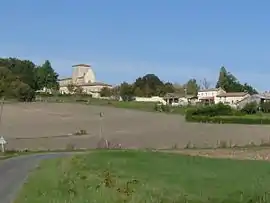 A general view of Chatenet | |
Location of Chatenet 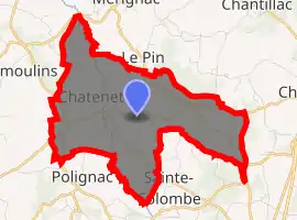
| |
 Chatenet  Chatenet | |
| Coordinates: 45°18′09″N 0°18′19″W | |
| Country | France |
| Region | Nouvelle-Aquitaine |
| Department | Charente-Maritime |
| Arrondissement | Jonzac |
| Canton | Les Trois Monts |
| Intercommunality | Haute-Saintonge |
| Government | |
| • Mayor (2008–2014) | Philippe Chailloux |
| Area 1 | 9.6 km2 (3.7 sq mi) |
| Population (2017-01-01)[1] | 222 |
| • Density | 23/km2 (60/sq mi) |
| Time zone | UTC+01:00 (CET) |
| • Summer (DST) | UTC+02:00 (CEST) |
| INSEE/Postal code | 17095 /17210 |
| Elevation | 61–123 m (200–404 ft) (avg. 85 m or 279 ft) |
| 1 French Land Register data, which excludes lakes, ponds, glaciers > 1 km2 (0.386 sq mi or 247 acres) and river estuaries. | |
Geography
Chatenet is a small commune situated between the market town of Montendre and the large village of Chevanceaux. It is principally a farming community; however in recent years tourism has become important. The location of Chatenet in the southern tip of the Charente Maritime provides the area with a warm climate. The Seugne flows north-northwestward through the middle of the commune and forms part of its southern and northern borders.
Population
| Year | Pop. | ±% |
|---|---|---|
| 1962 | 268 | — |
| 1968 | 275 | +2.6% |
| 1975 | 215 | −21.8% |
| 1982 | 210 | −2.3% |
| 1990 | 195 | −7.1% |
| 1999 | 188 | −3.6% |
| 2008 | 220 | +17.0% |
References
- "Populations légales 2017". INSEE. Retrieved 6 January 2020.
External links
| Wikimedia Commons has media related to Chatenet. |
| Authority control |
|---|
This article is issued from Wikipedia. The text is licensed under Creative Commons - Attribution - Sharealike. Additional terms may apply for the media files.