La Gripperie-Saint-Symphorien
La Gripperie-Saint-Symphorien is a commune in the Charente-Maritime department in southwestern France.
La Gripperie-Saint-Symphorien | |
|---|---|
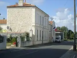 The town hall in La Gripperie-Saint-Symphorien | |
.svg.png.webp) Coat of arms | |
Location of La Gripperie-Saint-Symphorien 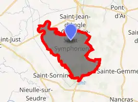
| |
 La Gripperie-Saint-Symphorien  La Gripperie-Saint-Symphorien | |
| Coordinates: 45°48′05″N 0°57′01″W | |
| Country | France |
| Region | Nouvelle-Aquitaine |
| Department | Charente-Maritime |
| Arrondissement | Rochefort |
| Canton | Marennes |
| Government | |
| • Mayor (2008–2014) | Denis Rouyer |
| Area 1 | 18.16 km2 (7.01 sq mi) |
| Population (2017-01-01)[1] | 593 |
| • Density | 33/km2 (85/sq mi) |
| Time zone | UTC+01:00 (CET) |
| • Summer (DST) | UTC+02:00 (CEST) |
| INSEE/Postal code | 17184 /17620 |
| Elevation | 2–39 m (6.6–128.0 ft) |
| 1 French Land Register data, which excludes lakes, ponds, glaciers > 1 km2 (0.386 sq mi or 247 acres) and river estuaries. | |
Population
| Year | Pop. | ±% |
|---|---|---|
| 1793 | 576 | — |
| 1800 | 505 | −12.3% |
| 1806 | 389 | −23.0% |
| 1821 | 484 | +24.4% |
| 1831 | 556 | +14.9% |
| 1836 | 564 | +1.4% |
| 1841 | 532 | −5.7% |
| 1846 | 560 | +5.3% |
| 1851 | 547 | −2.3% |
| 1856 | 520 | −4.9% |
| 1861 | 577 | +11.0% |
| 1866 | 566 | −1.9% |
| 1872 | 528 | −6.7% |
| 1876 | 519 | −1.7% |
| 1881 | 505 | −2.7% |
| 1886 | 532 | +5.3% |
| 1891 | 493 | −7.3% |
| 1896 | 534 | +8.3% |
| 1901 | 507 | −5.1% |
| 1906 | 515 | +1.6% |
| 1911 | 455 | −11.7% |
| 1921 | 387 | −14.9% |
| 1926 | 384 | −0.8% |
| 1931 | 377 | −1.8% |
| 1936 | 350 | −7.2% |
| 1946 | 323 | −7.7% |
| 1954 | 329 | +1.9% |
| 1962 | 324 | −1.5% |
| 1968 | 331 | +2.2% |
| 1975 | 321 | −3.0% |
| 1982 | 364 | +13.4% |
| 1990 | 402 | +10.4% |
| 1999 | 473 | +17.7% |
| 2008 | 443 | −6.3% |
References
- "Populations légales 2017". INSEE. Retrieved 6 January 2020.
| Wikimedia Commons has media related to La Gripperie-Saint-Symphorien. |
| Authority control |
|---|
This article is issued from Wikipedia. The text is licensed under Creative Commons - Attribution - Sharealike. Additional terms may apply for the media files.